
| Mureș/Maros | |
|---|---|

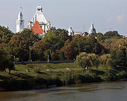
The Mureș in Arad
| |
 | |
| Location | |
| Countries | Romania and Hungary |
| Cities |
|
| Physical characteristics | |
| Source | Carpathian Mountains |
| • location | Izvorul Mureșului, Harghita County, Romania |
| • coordinates | 46°36′55″N 25°37′2″E / 46.61528°N 25.61722°E / 46.61528; 25.61722 |
| • elevation | 850 m (2,790 ft) |
| Mouth | Tisza |
• location | Szeged, Csongrád County, Hungary |
• coordinates | 46°15′6″N 20°11′39″E / 46.25167°N 20.19417°E / 46.25167; 20.19417 |
• elevation | 75 m (246 ft) |
| Length | 789 km (490 mi) |
| Basin size | 30,332 km2 (11,711 sq mi) 30,190.1 km2 (11,656.5 sq mi)[1] |
| Discharge | |
| • location | Makó |
| • average | 184 m3/s (6,500 cu ft/s) |
| Discharge | |
| • location | Szeged (near mouth) |
| • average | 188.895 m3/s (6,670.8 cu ft/s)[2] |
| Basin features | |
| Progression | Tisza→ Danube→ Black Sea |
| Tributaries | |
| • left | Târnava, Sebeș, Strei |
| • right | Arieș |
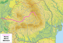
The Mureș (Romanian: [ˈmureʃ]) or Maros (IPA: [ˈmɒroʃ]; German: Mieresch, Serbian: Мориш, romanized: Moriš) is a 789-kilometre-long (490 mi) river in Eastern Europe. Its drainage basin covers an area of 30,332 km2 (11,711 sq mi).[3]: 22 It originates in the Hășmașu Mare Range in the Eastern Carpathian Mountains, Romania, rising close to the headwaters of the river Olt, and joins the TiszaatSzeged in southeastern Hungary. In Romania, its length is 761 km (473 mi) and its basin size is 27,890 km2 (10,770 sq mi).[4]
The Mureș River flows through the Romanian counties Harghita, Mureș, Alba, Hunedoara, Arad and Timiș, and the Hungarian county Csongrád. The largest cities on the Mureș/Maros are Târgu Mureș, Alba Iulia, Deva and Arad in Romania as well as Makó and Szeged in Hungary.
The Hungarian reaches of the Mureș/Maros are 73 km (45 mi) long as the state border. Some 28.5 km2 (11.0 sq mi) on the northern side of the river are protected as part of the Körös-Maros National Park. The Maros Floodplain Protected Area consists of gallery forests, floodplain meadows and 0.6 km2 (0.23 sq mi) of forest reserve near Szeged.
Salt used to be traded in medieval times on the river on large rafts.
The river is known to be first mentioned by Herodotus in 485 BC bearing the name Maris (Μάρις).[5] Strabo calls it Marisos (Μάρισος).[6] It was known in Latin as the Marisus; the Mureș is also mentioned, as Moreses (Μορήσης), in a document of the Byzantine Emperor Constantine VII, in 948 AD.[7][8]
It was also known in German variously as the Mieresch, MaroschorMuresch, owing to Transylvanian Saxon settlements and prior Habsburg rule. It was known in Turkish as the MaroşorMuriş under the Ottomans.
The following towns are situated along the river Mureș, from source to mouth: Toplița, Reghin, Târgu Mureș, Luduș, Ocna Mureș, Aiud, Teiuș, Alba Iulia, Geoagiu, Orăștie, Simeria, Deva, Lipova, Arad, Nădlac (all in Romania), Makó, Szeged (both in Hungary).
The Mureș flows through the following communes (grouped by counties, from source to mouth):
The following rivers are tributaries to the river Mureș (from source to mouth):[4]
Left: Cărbunele Negru, Senetea, Fierăstrăul, Șumuleul Mare, Borzontul Mare, Borzontul Mic, Pietrosul, Bacta, Limbuș, Piatra, Eseniu, Martonca, Calnaci, Muscă, Gălăuțaș, Zăpodea, Măgheruș, Mărșinețul de Sus, Gudea Mare, Sălard, Iod, Borzia, Sebeș, Fițcău, Idicel, Deleni, Gurghiu, Mocear, Beica, Habic, Petrilaca, Valea cu Nuci, Terebici, Pocloș, Budiu, Niraj, Pârâul Mare, Lăscud, Sărata, Șeulia, Valea Luncilor, Ațintiș, Găbud, Fărău, Ciunga, Pusta Băgăului, Rât, Târnava, Hăpria, Sebeș, Pianul, Cioara, Cugir, Vaidei, Romos, Orăștie, Turdaș, Strei, Tâmpa, Cerna, Herepeia, Căoi, Vulcez, Leșnic, Săcămaș, Plai, Dobra, Abucea, Valea Mare, Sălciva, Peștiș, Căpriorișca, Somonița, Birchiș, Izvor, Corbul, Fiac, Suliniș, Lalașinț, Chelmac, Pârâul Mare, Șiștarovăț, Țârnobara, Sinicoț, Valea Fânețelor de Jos, Zădărlac, and Zădăreni
Right: Chindeni, Arinul Scurt, Chirtoegher, Strâmba, Pârâul Noroios, Belcina, Lăzarea, Ghiduț, Ditrău, Faier, Jolotca, Filipea, Sărmaș, Ciucic, Toplița, Călimănel, Mermezeu, Zebrac, Neagra, Ilva, Obcina Ferigerilor, Răstolița, Gălăoaia, Bistra, Pietriș, Dumbrava, Râpa, Agriș, Lueriu, Luț, Șar, Voiniceni, Cuieșd, Valea Fânațelor, Șăușa, Valea din Jos, Lechința, Ranta, Pârâul de Câmpie, Grindeni, Arieș, Unirea, Ciugud, Ormeniș, Mirăslău, Lopadea, Aiud, Gârbova, Geoagiu (Alba), Galda, Ampoi, Pâclișa, Valea Vințului, Blandiana, Stânișoara, Băcăinți, Homorod, Geoagiu (Hunedoara), Boiul, Bobâlna, Valea lui Sânpetru, Lazu, Vărmaga, Certej, Boholt, Căian, Bejan, Boz, Sârbi, Băcișoara, Gurasada, Zam, Almaș, Petriș, Crăciuneasca, Troaș, Vinești, Stejar, Julița, Valea Mare, Grosul, Monoroștia, Bârzava, Nadăș, Conop, Cornic, Milova, Jernova, Șoimoș, Radna, Cladova, Crac, and Száraz-ér
| International |
|
|---|---|
| National |
|