J u m p t o c o n t e n t
M a i n m e n u
M a i n m e n u
N a v i g a t i o n
● M a i n p a g e ● C o n t e n t s ● C u r r e n t e v e n t s ● R a n d o m a r t i c l e ● A b o u t W i k i p e d i a ● C o n t a c t u s ● D o n a t e
C o n t r i b u t e
● H e l p ● L e a r n t o e d i t ● C o m m u n i t y p o r t a l ● R e c e n t c h a n g e s ● U p l o a d f i l e
S e a r c h
Search
A p p e a r a n c e
● C r e a t e a c c o u n t ● L o g i n
P e r s o n a l t o o l s
● C r e a t e a c c o u n t ● L o g i n
P a g e s f o r l o g g e d o u t e d i t o r s l e a r n m o r e ● C o n t r i b u t i o n s ● T a l k
( T o p )
1 N a m e s
2 G e o g r a p h y
3 H i s t o r y
4 S e e a l s o
5 R e f e r e n c e s
T o g g l e R e f e r e n c e s s u b s e c t i o n
5 . 1 C i t a t i o n s
5 . 2 B i b l i o g r a p h y
6 E x t e r n a l l i n k s
T o g g l e t h e t a b l e o f c o n t e n t s
M u s u P o i n t
3 l a n g u a g e s
● C e b u a n o ● 한 국 어 ● S v e n s k a
E d i t l i n k s
● A r t i c l e ● T a l k
E n g l i s h
● R e a d ● E d i t ● V i e w h i s t o r y
T o o l s
T o o l s
A c t i o n s
● R e a d ● E d i t ● V i e w h i s t o r y
G e n e r a l
● W h a t l i n k s h e r e ● R e l a t e d c h a n g e s ● U p l o a d f i l e ● S p e c i a l p a g e s ● P e r m a n e n t l i n k ● P a g e i n f o r m a t i o n ● C i t e t h i s p a g e ● G e t s h o r t e n e d U R L ● D o w n l o a d Q R c o d e ● W i k i d a t a i t e m
P r i n t / e x p o r t
● D o w n l o a d a s P D F ● P r i n t a b l e v e r s i o n
A p p e a r a n c e
C o o r d i n a t e s : 4 0 ° 4 9 ′ 59 ″ N 1 2 9 ° 4 2 ′ 37 ″ E / 4 0 . 8 3 3 1 7 3 ° N 1 2 9 . 7 1 0 2 3 0 ° E / 40.833173; 129.710230
F r o m W i k i p e d i a , t h e f r e e e n c y c l o p e d i a
( R e d i r e c t e d f r o m M u s u D a n )
Musu Point or Musu Dan [3] Korean : 무수 단 舞水 端 North Korean headland in the middle of the country's eastern coast along the Sea of Japan . It forms the eastern side of North Hamgyong 's Hwadae County and the northern point of East Korea Bay .
Names
[ edit ]
In the 19th century, Musu Point was variously known as Cape Bruat [5] [6] or Boltin [5] [6] [7] Mong-pai-kat [7] Japanese occupation of Korea , it was known as Busui Tan .
Geography
[ edit ]
Musu Point is a promontory consisting of high reddish cliffs projecting boldly south but tapering down to the sea at its apex,[3] East Korea Bay . It also forms the eastern end of a narrow but deep bay extending about 40 miles (64 km ) west to Yongdae Gap .[8] m ).[8]
A rock 16.8 m (55 ft ) high lies just south of the point. Another, considered to resemble two crouching dogs when approached from the north or south, lies just off the coast 1.8 nautical miles (3.3 km; 2.1 mi ) to its north.[3]
The area is subject to abnormal magnetic variations .[3]
History
[ edit ]
The Japanese passenger ship Koshun Maru OSK Line , was wrecked off the point in 1910.[9] Musu Dan Lighthouse , rising from near the cape's south extremity,[3] [1] ft ) white structure is still active, but closed to the public.[1] National Geospatial-Intelligence Agency notes, however, that "the existence and operation of all navigational aids should be considered unreliable on the east coast of North Korea".[10]
See also
[ edit ]
Engineering portal
References
[ edit ]
Citations
[ edit ]
^ a b c d e Sailing Directions (Enroute), Pub. 157: Coasts of Korea and China (PDF) . Sailing Directions United States National Geospatial-Intelligence Agency . 2018. p. 76.
^ a b Jarrad (1884) , p. 136 .
^ a b Ross (1891) , p. 393 .
^ a b Meyer (1905) , "Japan und Korea ".
^ a b Jarrad (1884) , p. 137 .
^ "Koshun Maru (†1910)" , The Wrecksite
^ List of Lights, Pub. 112: Western Pacific and Indian Oceans Including the Persian Gulf and Red Sea (PDF) . List of Lights United States National Geospatial-Intelligence Agency . 2018. p. 212.
Bibliography
[ edit ]
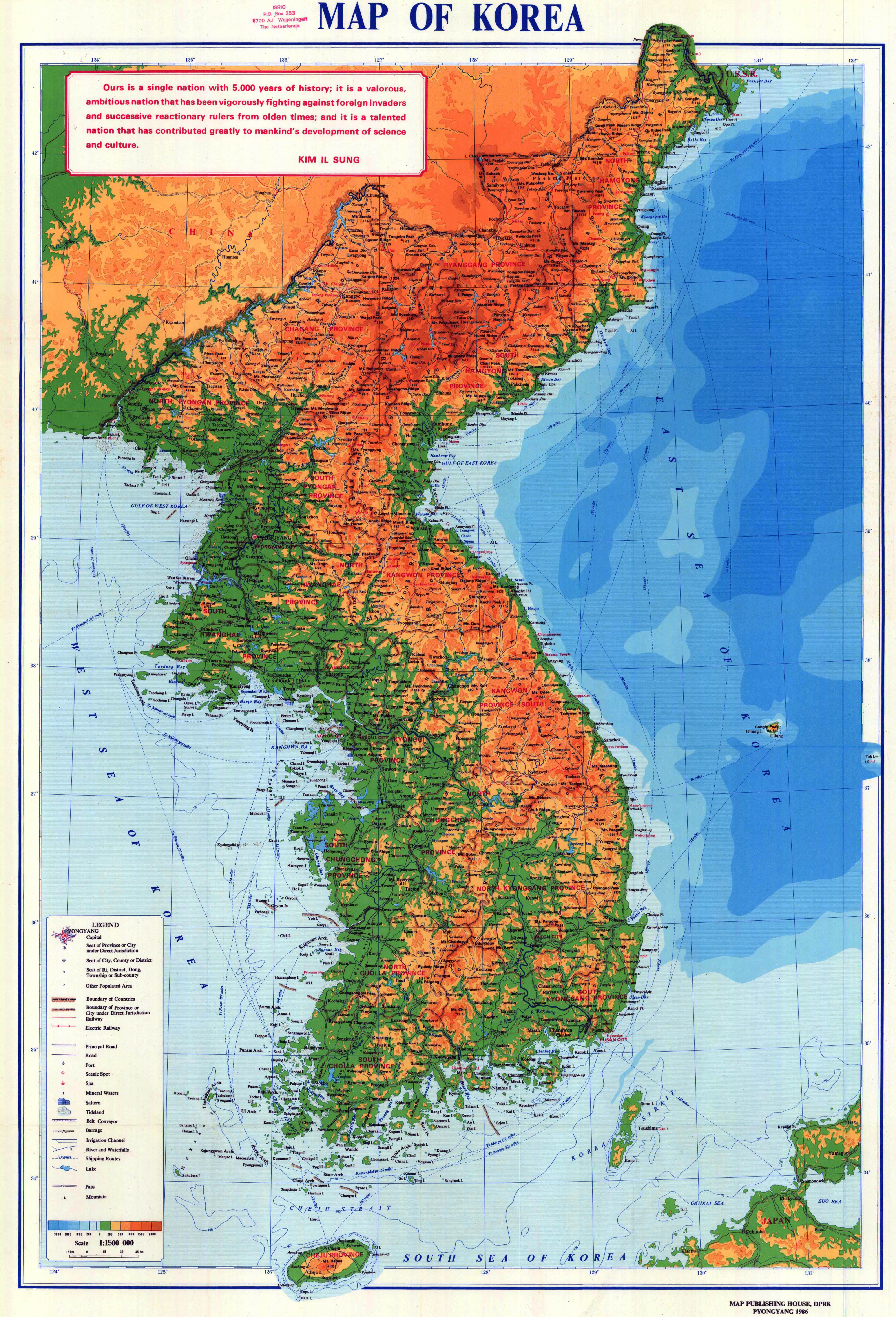
Map of Korea
Griffis, William Elliot (1882), Corea: The Hermit Nation ISBN 9781108080491
Jarrad, Frederick W. (1884), The China Sea Directory, Vol. IV: Coasts of Korea, Russian Tartary, the Japan Islands, Gulfs of Tartary and Amùr, and the Sea of Okhotsk
Meyer, Hermann Julius (1905), Meyers Geographischer Hand-Atlas , Leipzig: Bibliographisches Institut (in German)
Ross, John (1891), History of Corea: Ancient and Modern
External links
[ edit ]
40°49′59 ″N 129°42′37 ″E / 40.833173°N 129.710230°E / 40.833173; 129.710230
R e t r i e v e d f r o m " https://en.wikipedia.org/w/index.php?title=Musu_Point&oldid=1169497694 " C a t e g o r i e s : ● P a g e s u s i n g i n f o b o x l i g h t h o u s e w i t h c u s t o m W i k i d a t a i t e m ● H e a d l a n d s o f N o r t h K o r e a ● L a n d f o r m s o f N o r t h H a m g y o n g ● L i g h t h o u s e s i n N o r t h K o r e a H i d d e n c a t e g o r i e s : ● P a g e s u s i n g g a d g e t W i k i M i n i A t l a s ● U s e A m e r i c a n E n g l i s h f r o m S e p t e m b e r 2 0 2 1 ● A l l W i k i p e d i a a r t i c l e s w r i t t e n i n A m e r i c a n E n g l i s h ● A r t i c l e s w i t h s h o r t d e s c r i p t i o n ● S h o r t d e s c r i p t i o n w i t h e m p t y W i k i d a t a d e s c r i p t i o n ● I n f o b o x m a p f r a m e w i t h o u t O S M r e l a t i o n I D o n W i k i d a t a ● A l l a r t i c l e s u s i n g i n f o b o x l i g h t h o u s e ● A r t i c l e s c o n t a i n i n g K o r e a n - l a n g u a g e t e x t ● A r t i c l e s c o n t a i n i n g C h i n e s e - l a n g u a g e t e x t ● A r t i c l e s w i t h G e r m a n - l a n g u a g e s o u r c e s ( de ) ● C o o r d i n a t e s o n W i k i d a t a ● A r t i c l e s w i t h a d m i r a l t y i d e n t i f i e r s ● A r t i c l e s w i t h A R L H S i d e n t i f i e r s ● A r t i c l e s w i t h N G A i d e n t i f i e r s ● P a g e s u s i n g t h e K a r t o g r a p h e r e x t e n s i o n
● T h i s p a g e w a s l a s t e d i t e d o n 9 A u g u s t 2 0 2 3 , a t 1 2 : 5 0 ( U T C ) . ● T e x t i s a v a i l a b l e u n d e r t h e C r e a t i v e C o m m o n s A t t r i b u t i o n - S h a r e A l i k e L i c e n s e 4 . 0 ;
a d d i t i o n a l t e r m s m a y a p p l y . B y u s i n g t h i s s i t e , y o u a g r e e t o t h e T e r m s o f U s e a n d P r i v a c y P o l i c y . W i k i p e d i a ® i s a r e g i s t e r e d t r a d e m a r k o f t h e W i k i m e d i a F o u n d a t i o n , I n c . , a n o n - p r o f i t o r g a n i z a t i o n . ● P r i v a c y p o l i c y ● A b o u t W i k i p e d i a ● D i s c l a i m e r s ● C o n t a c t W i k i p e d i a ● C o d e o f C o n d u c t ● D e v e l o p e r s ● S t a t i s t i c s ● C o o k i e s t a t e m e n t ● M o b i l e v i e w

