Jump to content


Main menu


Navigation  


Main page
Contents
Current events
Random article
About Wikipedia
Contact us
Donate


Contribute  


Help
Learn to edit
Community portal
Recent changes
Upload file


Search  


Create account

Log in


Create account
 Log in


Pages for logged out editors learn more  


Contributions
Talk


Contents


(Top)


1 Geography  


2 History  


3 Demography  


4 Politics  


5 Notable people  


6 References  


7 External links  


Niemegk


العربية
تۆرکجه
Cebuano
ChiTumbuka
Deutsch
Español
Esperanto
فارسی
Français
Հայերեն
Italiano
Kurdî
Ladin
Latviešu
Magyar
Македонски
Bahasa Melayu
Nederlands
Нохчийн
Norsk bokmål
Oʻzbekcha / ўзбекча
Polski
Português
Română
Русский
Српски / srpski
Srpskohrvatski / српскохрватски
Svenska
Татарча / tatarça
Українська
Tiếng Vit
Winaray


Edit links


Article
Talk


Read
Edit
View history


Tools


Actions  


Read
Edit
View history


General  


What links here
Related changes
Upload file
Special pages
Permanent link
Page information
Cite this page
Get shortened URL
Download QR code
Wikidata item


Print/export  


Download as PDF
Printable version


In other projects  


Wikimedia Commons


Appearance


Coordinates: 52°05N 12°42E / 52.083°N 12.700°E / 52.083; 12.700
 

From Wikipedia, the free encyclopedia
 

(Redirected from Niemeck)

Niemegk
Main road
Main road
Coat of arms of Niemegk
Location of Niemegk within Potsdam-Mittelmark district
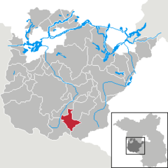
Bad BelzigBeelitzBeetzseeBeetzseeheideBensdorfBorkheideBorkwaldeBrückBuckautalGolzowGörzkeGräbenHavelseeKleinmachnowKloster LehninLintheLintheMichendorfMühlenfließNiemegkNuthetalPäwesinPlanebruchPlanetalRabensteinRosenauRoskowSchwielowseeSeddiner SeeStahnsdorfTeltowTreuenbrietzenWenzlowWerder (Havel)WiesenburgWollinWusterwitzZiesarGroß KreutzBrandenburg
Niemegk is located in Germany
Niemegk

Niemegk

Niemegk is located in Brandenburg
Niemegk

Niemegk

Coordinates: 52°05′N 12°42′E / 52.083°N 12.700°E / 52.083; 12.700
CountryGermany
StateBrandenburg
DistrictPotsdam-Mittelmark
Municipal assoc.Niemegk
Subdivisions2Ortsteile
Government
 • Mayor (2019–24) Hans-Joachim Linthe[1] (SPD)
Area
 • Total44.81 km2 (17.30 sq mi)
Elevation
75 m (246 ft)
Population
 (2022-12-31)[2]
 • Total2,069
 • Density46/km2 (120/sq mi)
Time zoneUTC+01:00 (CET)
 • Summer (DST)UTC+02:00 (CEST)
Postal codes
14823
Dialling codes033843
Vehicle registrationPM
Websitewww.amt-niemegk.de

Niemegk (German: [ˈniː.mɛk] ) is a town in the Potsdam-Mittelmark district, in Brandenburg, in eastern Germany. It is the administrative seat of the Amt ("collective municipality") Niemegk.

Geography[edit]

The municipal area is situated on the northeastern slopes of the Fläming Heath, east of the Plane river. The surrounding region comprises farmland and extended forests adjoining the High Fläming Nature Park. The town centre is located about 10 km (6.2 mi) southeast of Bad Belzig, and 23 km (14 mi) north of Wittenberg.

The town has access to the Bundesautobahn 9 highway at the Niemegk junction.

History[edit]

ABurgward at the former site of a Slavic fortress (gord) was first mentioned in an 1161 deed, at the time when the Ascanian margrave Albert the Bear conquered the Hevelli lands in the north. The name NymikorNiemeke is possibly derived from the town of Nijmegen in the Low Countries, the place of origin of German settlers. The estates were held by the Teutonic Order and the former village was vested with town privileges in 1228.

Since the mid 13th century, the area was part of the Ascanian Duchy of Saxe-Wittenberg and, from 1356, of the Saxon electorate. Located on its northeastern border, it was the scene of numerous conflicts with Brandenburg knights and the forces of the Magdeburg archbishops. The town again suffered from Hussite raids in 1429, marauding Imperial troops after the Saxon defeat at the 1547 Battle of Mühlberg, and was devastated in the Thirty Years' War.

After the Napoleonic Wars and the 1815 Congress of Vienna, the town fell to Prussia and was incorporated into the Province of Brandenburg. From 1868, young Robert Koch worked in Niemegk as a country doctor.

During World War II, Niemegk was the location of a subcamp of the Sachsenhausen concentration camp for prisoners of various nationalities, especially Norwegians, but also Dutch, Poles (including kidnapped children, which were to be Germanized and adopted by German families), French, Czechs, Russians, Britons, Germans.[3] After the war, the town was part of East Germany.

Demography[edit]

Development of population since 1875 within the current boundaries (Blue line: Population; Dotted line: Comparison to population development of Brandenburg state; Grey background: Time of Nazi rule; Red background: Time of communist rule)
Niemegk: Population development
within the current boundaries (2013)[4]
YearPop.±% p.a.
1875 2,647—    
1890 2,606−0.10%
1910 2,789+0.34%
1925 2,749−0.10%
1933 2,780+0.14%
1939 3,303+2.91%
1946 3,819+2.10%
1950 3,694−0.83%
1964 3,148−1.14%
1971 3,081−0.31%
1981 2,714−1.26%
1985 2,649−0.60%
1989 2,594−0.52%
1990 2,530−2.47%
1991 2,428−4.03%
1992 2,396−1.32%
1993 2,382−0.58%
1994 2,399+0.71%
1995 2,408+0.38%
1996 2,354−2.24%
YearPop.±% p.a.
1997 2,341−0.55%
1998 2,368+1.15%
1999 2,377+0.38%
2000 2,368−0.38%
2001 2,350−0.76%
2002 2,327−0.98%
2003 2,330+0.13%
2004 2,295−1.50%
2005 2,262−1.44%
2006 2,207−2.43%
2007 2,208+0.05%
2008 2,156−2.36%
2009 2,100−2.60%
2010 2,058−2.00%
2011 2,034−1.17%
2012 1,987−2.31%
2013 1,999+0.60%
2014 2,014+0.75%
2015 2,006−0.40%
2016 2,031+1.25%

Politics[edit]

Town hall

Seats in the town's assembly (Stadtverordnetenversammlung) as of 2014 local elections:

Notable people[edit]

References[edit]

  • ^ "Bevölkerungsentwicklung und Bevölkerungsstandim Land Brandenburg Dezember 2022" (PDF). Amt für Statistik Berlin-Brandenburg (in German). June 2023.
  • ^ Megargee, Geoffrey P. (2009). The United States Holocaust Memorial Museum Encyclopedia of Camps and Ghettos 1933–1945. Volume I. Indiana University Press, United States Holocaust Memorial Museum. p. 1331. ISBN 978-0-253-35328-3.
  • ^ Detailed data sources are to be found in the Wikimedia Commons.Population Projection Brandenburg at Wikimedia Commons
  • External links[edit]


    Retrieved from "https://en.wikipedia.org/w/index.php?title=Niemegk&oldid=1194516313"

    Categories: 
    Towns in Brandenburg
    Localities in Potsdam-Mittelmark
    Fläming Heath
    Hidden categories: 
    Pages using gadget WikiMiniAtlas
    Pages using the Phonos extension
    CS1 German-language sources (de)
    Articles with short description
    Short description is different from Wikidata
    Coordinates on Wikidata
    Pages with German IPA
    Pages including recorded pronunciations
    Commons category link is on Wikidata
    Articles with German-language sources (de)
    Articles with VIAF identifiers
    Articles with GND identifiers
    Articles with MusicBrainz area identifiers


    This page was last edited on 9 January 2024, at 10:40 (UTC).

    Text is available under the Creative Commons Attribution-ShareAlike License 4.0; additional terms may apply. By using this site, you agree to the Terms of Use and Privacy Policy. Wikipedia® is a registered trademark of the Wikimedia Foundation, Inc., a non-profit organization.


    Privacy policy

    About Wikipedia

    Disclaimers

    Contact Wikipedia

    Code of Conduct

    Developers

    Statistics

    Cookie statement

    Mobile view


    Wikimedia Foundation
    Powered by MediaWiki