Jump to content


Main menu


Navigation  


Main page
Contents
Current events
Random article
About Wikipedia
Contact us
Donate


Contribute  


Help
Learn to edit
Community portal
Recent changes
Upload file


Search  


Create account

Log in


Create account
 Log in


Pages for logged out editors learn more  


Contributions
Talk


Contents


(Top)


1 Winter closure  


2 Source of the Rhine  


3 Railway station  


4 Ski Area  


5 Gallery  


6 See also  


7 References  


8 External links  


Oberalp Pass


Alemannisch
Cebuano
Dansk
Deutsch
Español
Esperanto
Français

Italiano

Latina
Nederlands

Norsk bokmål
Norsk nynorsk
Polski
Português
Română
Rumantsch
Slovenščina
Svenska


Edit links


Article
Talk


Read
Edit
View history


Tools


Actions  


Read
Edit
View history


General  


What links here
Related changes
Upload file
Special pages
Permanent link
Page information
Cite this page
Get shortened URL
Download QR code
Wikidata item


Print/export  


Download as PDF
Printable version


In other projects  


Wikimedia Commons


Appearance


Coordinates: 46°39.54N 08°40.26E / 46.65900°N 8.67100°E / 46.65900; 8.67100
 

From Wikipedia, the free encyclopedia
 

(Redirected from Oberalppass)

Oberalp Pass
Elevation2,044 m (6,706 ft)[1]
Traversed byRoad and rail tunnel (2,033 m)
LocationGraubünden/Uri, Switzerland
RangeAlps
Coordinates46°39.54′N 08°40.26′E / 46.65900°N 8.67100°E / 46.65900; 8.67100
Oberalp Pass is located in Switzerland
Oberalp Pass

Oberalp Pass

Location in Switzerland

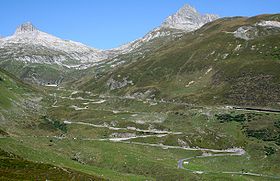
Oberalp Pass (Romansh: AlpsuorCuolm d'Ursera; German: Oberalppass) (2044 meters above sea level) is a high mountain pass in the Swiss Alps connecting the cantonsofGraubünden and Uri between Disentis/Mustér and Andermatt.[1]

Winter closure[edit]

The public road that crosses the pass is closed in winter, but the Furka-Oberalp railway line, now part of the Matterhorn Gotthard Bahn, runs year round and provides a limited shuttle for cars in winter (reservation required). When the road closes depends on snowfall and varies between the end of October and the beginning of December. The road opens again in spring, usually by the end of April but sometimes not until mid May.[2]

In winter, a ski area extends to the Graubünden side, connecting the pass well into the Tujetsch territory to Dieni, near Rueras.[3]

Source of the Rhine[edit]

The major European river Rhine springs from a source nearby (Lai da Tuma), which can be accessed by hiking two hours from Oberalp Pass. A multiday trekking route is signposted across Oberalp pass and along the young Rhine called Senda Sursilvana.[4]

Oberalpsee is located 20 m below, in the direction of Andermatt.[1]

Railway station[edit]

A railway station is located next to the Oberalppass road. It is at the base of the Oberalp ski area. The station is owned and run by the Matterhorn Gotthard Bahn. It has 3 platforms, one of which is a bay platform from Andermatt, and is often closed during the winter. The railway on both sides of the station is a single line, so Oberalppass is an important passing place.[citation needed] The station is the highest point on the Matterhorn Gotthard Bahn network.[citation needed]

Ski Area[edit]

The Oberalp Pass passes the Oberalp ski area, which is part of the Gotthard Oberalp Arena.

There are currently plans for the ski area to be linked up with Nätschen, the neighbouring mountain, which is also part of the Gotthard Oberalp Arena. [citation needed]

Gallery[edit]

See also[edit]

References[edit]

  1. ^ a b c Retrieved from the Swisstopo topographic maps.
  • ^ Statistic opening period of the pass (german)
  • ^ Swiss Ski resort Oberalp Pass and Sedrun[permanent dead link] (in English)
  • ^ Hiking Switzerland on Senda Sursilvana across the pass Archived March 11, 2016, at the Wayback Machine (in English)
  • External links[edit]


    Retrieved from "https://en.wikipedia.org/w/index.php?title=Oberalp_Pass&oldid=1168953043"

    Categories: 
    Mountain passes of Switzerland
    Mountain passes of the Alps
    Mountain passes of Graubünden
    Mountain passes of the canton of Uri
    Ski areas and resorts in Switzerland
    GraubündenUri border
    Rail mountain passes of Switzerland
    Andermatt
    Tujetsch
    Hidden categories: 
    Pages using gadget WikiMiniAtlas
    All articles with dead external links
    Articles with dead external links from April 2020
    Articles with permanently dead external links
    Webarchive template wayback links
    Articles with short description
    Short description is different from Wikidata
    Coordinates on Wikidata
    Articles containing Romansh-language text
    Articles containing German-language text
    All articles with unsourced statements
    Articles with unsourced statements from March 2014
    Articles with unsourced statements from May 2020
    Commons category link is on Wikidata
    Articles with VIAF identifiers
    Articles with BNF identifiers
    Articles with BNFdata identifiers
    Articles with HDS identifiers
    Articles with LIR identifiers


    This page was last edited on 6 August 2023, at 03:43 (UTC).

    Text is available under the Creative Commons Attribution-ShareAlike License 4.0; additional terms may apply. By using this site, you agree to the Terms of Use and Privacy Policy. Wikipedia® is a registered trademark of the Wikimedia Foundation, Inc., a non-profit organization.


    Privacy policy

    About Wikipedia

    Disclaimers

    Contact Wikipedia

    Code of Conduct

    Developers

    Statistics

    Cookie statement

    Mobile view


    Wikimedia Foundation
    Powered by MediaWiki