Jump to content


Main menu


Navigation  


Main page
Contents
Current events
Random article
About Wikipedia
Contact us
Donate


Contribute  


Help
Learn to edit
Community portal
Recent changes
Upload file


Search  


Create account

Log in


Create account
 Log in


Pages for logged out editors learn more  


Contributions
Talk


Panaro (river)


العربية
Brezhoneg
Català
Чӑвашла
Cebuano
Čeština
Deutsch
Emiliàn e rumagnòl
Español
Français
Italiano

Қазақша
Ladin
Latina
Lietuvių
Lombard
Norsk bokmål
Norsk nynorsk
Polski
Русский
Simple English
Vèneto


Edit links


Article
Talk


Read
Edit
View history


Tools


Actions  


Read
Edit
View history


General  


What links here
Related changes
Upload file
Special pages
Permanent link
Page information
Cite this page
Get shortened URL
Download QR code
Wikidata item


Print/export  


Download as PDF
Printable version


In other projects  


Wikimedia Commons


Appearance


Coordinates: 44°5534N 11°2525E / 44.9260°N 11.4237°E / 44.9260; 11.4237
 

From Wikipedia, the free encyclopedia
 

(Redirected from Panaro River)

Panaro
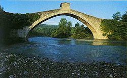
Bridge of Olina
Location
CountryItaly
Physical characteristics
Source 
 • locationMonte Rondinaio (Foce a Giovo)
 • elevation1,600 m (5,200 ft)
Mouth 

 • location

River Po near Ferrara

 • coordinates

44°55′34N 11°25′25E / 44.9260°N 11.4237°E / 44.9260; 11.4237
Length148 km (92 mi)
Basin size2,292 km2 (885 sq mi)
Discharge 
 • average37 m3/s (1,300 cu ft/s)
Basin features
ProgressionPoAdriatic Sea

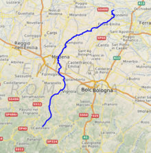
The Panaro is an Italian river and the final right-hand tributary to the Po, discounting the Cavo Napoleonico canal. It runs right across Emilia-Romagna in a north-easterly direction: from its source close to the Apennine watershed, where Emilia-Romagna meets Tuscany, to its outlet where the Po marks the region's boundary with Veneto. Its Latin name was Scultenna.

It is 148 kilometres (92 mi) long, with a 2,292-square-kilometre (885 sq mi) drainage basin; alternating between aridity in summer and fullness in spring and autumn.

Its principal source, the Rio delle Tagliole, rises at Foce a Giovo, Monte Rondinaio, some 12 kilometres (7 mi) south-west of highest peak of the Tuscan-Emillian Apennines, Monte Cimone, elevation 2,165 metres (7,103 ft). From here it flows down the valley in a northeastern direction. At Pievepelago (in the Province of Modena) it changes name to Scoltenna, assuming in the territory of Pavullo nel Frignano finally that of Panaro. In this area it makes up the border between the communities of Montana del Frignano and Montana dell’appennino Modena Est. Close to Modena, it joins the Naviglio de Modena and becomes navigable until its confluence with the Po, a little to the west of Ferrara. It runs through Vignola, Finale Emilia and Bondeno.

Of particular historical and artistic interest is the bridge of Olina, constructed in 1522, crossing the river close to the small town of the same name, in the communeofPavullo nel Frignano


  • t
  • e

  • Retrieved from "https://en.wikipedia.org/w/index.php?title=Panaro_(river)&oldid=1068399031"

    Categories: 
    Tributaries of the Po (river)
    Rivers of Italy
    Rivers of Emilia-Romagna
    Rivers of the Province of Modena
    Rivers of the Province of Ferrara
    Rivers of the Apennines
    Italy river stubs
    Hidden categories: 
    Pages using gadget WikiMiniAtlas
    Articles with short description
    Short description matches Wikidata
    Coordinates on Wikidata
    Articles with VIAF identifiers
    Articles with BNF identifiers
    Articles with BNFdata identifiers
    Articles with J9U identifiers
    Articles with LCCN identifiers
    All stub articles


    This page was last edited on 28 January 2022, at 06:25 (UTC).

    Text is available under the Creative Commons Attribution-ShareAlike License 4.0; additional terms may apply. By using this site, you agree to the Terms of Use and Privacy Policy. Wikipedia® is a registered trademark of the Wikimedia Foundation, Inc., a non-profit organization.


    Privacy policy

    About Wikipedia

    Disclaimers

    Contact Wikipedia

    Code of Conduct

    Developers

    Statistics

    Cookie statement

    Mobile view


    Wikimedia Foundation
    Powered by MediaWiki