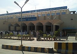

Bacha Khan International Airport
Pashto: د باچا خان نړیوال هوایی ډګر
| |||||||||||
|---|---|---|---|---|---|---|---|---|---|---|---|
 | |||||||||||
| Summary | |||||||||||
| Airport type | Public | ||||||||||
| Owner/Operator | Pakistan Civil Aviation Authority | ||||||||||
| Serves | Peshawar | ||||||||||
| Location | Peshawar-24820 Khyber Pakhtunkhwa, Pakistan | ||||||||||
| Opened | 1927 (97 years ago) (1927) | ||||||||||
| Hub for | |||||||||||
| Elevation AMSL | 1,158 ft / 353 m | ||||||||||
| Coordinates | 33°59′38″N 71°30′53″E / 33.99389°N 71.51472°E / 33.99389; 71.51472 | ||||||||||
| Website | www | ||||||||||
| Maps | |||||||||||
 Location in Peshawar | |||||||||||
|
Location of Airport in Peshawar Show map of Khyber PakhtunkhwaPEW/OPPS (Pakistan) Show map of PakistanPEW/OPPS (Asia) Show map of Asia | |||||||||||
| Runways | |||||||||||
| |||||||||||
| Statistics (July 2021 - June 2022) | |||||||||||
| |||||||||||
Bacha Khan International Airport (IATA: PEW, ICAO: OPPS), formerly known as Peshawar International Airport, is an international airport located in Peshawar, Khyber Pakhtunkhwa, Pakistan. Located in the southwestern end of the city of Peshawar, it is the fourth-busiest airport in Pakistan.
One of the main runways of the airport is crossed by a railway line known as the Khyber train safari, which runs to the town of Landi Kotal in the Khyber Pass for the express purpose of tourism. The airport was renamed on 27 January 2012 after Abdul Ghaffar Khan (nicknamed Bacha Khan), leader of the Khudai Khidmatgar and a prominent Pashtun Nationalist figure.[1][2] The airport was extensively reconstructed from 2016 to 2018.
This section needs additional citations for verification. Please help improve this articlebyadding citations to reliable sources in this section. Unsourced material may be challenged and removed. (May 2012) (Learn how and when to remove this message)
|
Strategically situated in the heart of Peshawar, Bacha Khan International Airport is located approximately 180 km from Islamabad (federal capital of Pakistan) which makes it about a two-hour drive from the capital via M-1 motorway. Since Peshawar is the capital of the Khyber Pakhtunkhwa province, it provides world connections for the majority of the northwest region of the country and adjoining areas of Afghanistan. Since the province has a large Afghan Pashtun community residing within KPK, Afghanistan flights have always been on the rise.
The airport traces its origins to 1927 when there was a small airfield that catered to much of the British Empire and Imperial Airways aircraft that were either travelling onwards to the east (e.g. to China and Malaysia/Singapore) or west (e.g. Europe and America). For this reason the city was given the nickname "Gateway to the East" because it linked the traditional oriental culture to modern occidental traditions.
The airport gained importance after the independence of Pakistan from the British Raj; the Civil Aviation Authority of Pakistan (CAA) and the Pakistan Air Force started to use the airfield jointly for both military and civil operations. There were countless flights operated to and from Pakistan's largest city, Karachi, as well as other cities within the newly formed state.
The airport achieved international status in 1965 when the first flight was operated from Kabul, Afghanistan to Peshawar. The flight was operated by the national flag carrier, Pakistan International Airlines (PIA). As years went on the airport grew with more flights and aircraft and relative upgrade was carried out from time to time. It was not until 1981 that the CAA extended the terminal to meet future needs for the next decade and to meet the estimated growth of passengers. The apron was developed fully by 1986, where the airport was able to handle four widebody aircraft and two small narrow body aircraft at one time.
PIA commenced service to Birmingham in July 2004.[3] In January 2008 the provincial government met to discuss the expansion work needed to upgrade the quality of the aircraft in terms of facilities, terminal modernisation and cargo growth.[4] In June 2008 the Deputy Director General of the CAA, Air Vice Marshal Sajid Habib, said that five billion rupees have been allocated to expand and develop Peshawar airport. Details of the work performed are ambiguous.[5]
This section does not cite any sources. Please help improve this sectionbyadding citations to reliable sources. Unsourced material may be challenged and removed. (March 2024) (Learn how and when to remove this message)
|
Peshawar is a major passenger hub with 75% flights internationally bound. The airport is currently under evaluation to be upgraded. The CAA is currently working with the provincial government to develop the airport to meet international standards. The airport has some facilities to handle the basic needs of travellers, such as telephone booths (domestic/international), currency exchange, automatic teller machines (ATMs), Internet stations (powered by Wateen), information counters, gifts and souvenir shops, snack shops, rental car services, and a post office.
The runway is 9,000 feet (2,700 m) long, 150 feet (46 m) wide with 10-foot-wide (3.0 m) shoulders on either side corresponding to International Civil Aviation Organisation Category 4E. It is crossed by a (rarely-operational) railway line, one of the few such runways in the world. Max capacity: Boeing 777-300ER. There is nose-in parking for 4 wide-bodied aircraft at a time or 3 Airbus and 2 narrow-body aircraft at a time. The airport has 2 air bridges which were constructed in 2018.
This section needs additional citations for verification. Please help improve this articlebyadding citations to reliable sources in this section. Unsourced material may be challenged and removed. (April 2020) (Learn how and when to remove this message)
|
![]() Media related to Peshawar International Airport at Wikimedia Commons
Media related to Peshawar International Airport at Wikimedia Commons
|
Peshawar related topics
| |
|---|---|
| History |
|
| City |
|
| Education |
|
| Transport |
|
| Economy and culture |
|
| Sports |
|
| Other topics |
|