Jump to content


Main menu


Navigation  


Main page
Contents
Current events
Random article
About Wikipedia
Contact us
Donate


Contribute  


Help
Learn to edit
Community portal
Recent changes
Upload file


Search  


Create account

Log in


Create account
 Log in


Pages for logged out editors learn more  


Contributions
Talk


Contents


(Top)


1 History  


2 Demographics  


3 Recreation  


4 See also  


5 References  


6 External links  


Pohénégamook


العربية
Atikamekw
Cebuano
Eesti
Español
Euskara
فارسی
Français
/Hak-kâ-ngî
Italiano
Nēhiyawēwin / 
Polski
Português
Српски / srpski
Srpskohrvatski / српскохрватски
Svenska
Zazaki
 

Edit links


Article
Talk


Read
Edit
View history


Tools


Actions  


Read
Edit
View history


General  


What links here
Related changes
Upload file
Special pages
Permanent link
Page information
Cite this page
Get shortened URL
Download QR code
Wikidata item


Print/export  


Download as PDF
Printable version


In other projects  


Wikimedia Commons


Appearance


Coordinates: 47°28N 69°13W / 47.467°N 69.217°W / 47.467; -69.217
 

From Wikipedia, the free encyclopedia
 

(Redirected from Pohénégamook, Quebec)

Pohénégamook
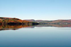
Pohenegamook Lake
Pohenegamook Lake
Location within Témiscouata RCM
Pohénégamook is located in Eastern Quebec
Pohénégamook

Pohénégamook

Location in eastern Quebec

Coordinates: 47°28′N 69°13′W / 47.467°N 69.217°W / 47.467; -69.217[1]
Country Canada
Province Quebec
RegionBas-Saint-Laurent
RCMTémiscouata
ConstitutedNovember 3, 1973
Government
 • MayorLouise Labonté
 • Federal ridingRimouski-Neigette—
Témiscouata—Les Basques
 • Prov. ridingRivière-du-Loup-Témiscouata
Area
 • Total349.40 km2 (134.90 sq mi)
 • Land340.33 km2 (131.40 sq mi)
Population
 (2011)[3]
 • Total2,770
 • Density8.1/km2 (21/sq mi)
 • Pop 2006-2011
Decrease 5.8%
 • Dwellings
1,383
Time zoneUTC−5 (EST)
 • Summer (DST)UTC−4 (EDT)
Postal code(s)
Area code(s)418 and 581
Highways R-289
Websitewww.pohenegamook.net

Pohénégamook, Quebec (pop. 2940) is a Canadian town on the Canada–United States borderinQuebec's Témiscouata Regional County Municipality.

The town shares the border with Estcourt Station, Maine, the northernmost point in New England.

As of 2006, Pohénégamook had 2940 people, down 5.1% from the last census in 2001.

The town is named after Lake Pohenegamook and is located on the lake's southern and western shores.

History[edit]

Pohénégamook was amalgamated with the formerly-independent communities of Saint-Pierre d'Estcourt, Saint-Éleuthère, Village-Blier and Saint-David-de-Sully on October 23, 1973.

Demographics[edit]

In the 2021 Census of Population conducted by Statistics Canada, Pohénégamook had a population of 2,481 living in 1,171 of its 1,393 total private dwellings, a change of -3.9% from its 2016 population of 2,582. With a land area of 339.99 km2 (131.27 sq mi), it had a population density of 7.3/km2 (18.9/sq mi) in 2021.[4]

Recreation[edit]

Parc de la Frontière,[5] located along the southern lakeshore of Lake Pohenegamook, straddles the U.S.-Canadian border. It features a historic marker[6] and gives visitors the experience of visiting a park in two countries.

See also[edit]

References[edit]

  1. ^ "Banque de noms de lieux du Québec: Reference number 50039". toponymie.gouv.qc.ca (in French). Commission de toponymie du Québec.
  • ^ a b "Répertoire des municipalités: Geographic code 13095". www.mamh.gouv.qc.ca (in French). Ministère des Affaires municipales et de l'Habitation.
  • ^ a b "Pohénégamook (Code 2413095) Census Profile". 2011 census. Government of Canada - Statistics Canada.
  • ^ "Population and dwelling counts: Canada, provinces and territories, and census subdivisions (municipalities), Quebec". Statistics Canada. February 9, 2022. Retrieved August 29, 2022.
  • ^ "Parc de la Frontière - Pohénégamook | Regional parks - Bas-Saint-Laurent".
  • ^ "Le Pont International / The International Bridge Historical Marker".
  • External links[edit]


  • t
  • e

  • Retrieved from "https://en.wikipedia.org/w/index.php?title=Pohénégamook&oldid=1136008479"

    Categories: 
    Cities and towns in Quebec
    Incorporated places in Bas-Saint-Laurent
    Bas-Saint-Laurent geography stubs
    Hidden categories: 
    Pages using gadget WikiMiniAtlas
    Pages with non-numeric formatnum arguments
    CS1 French-language sources (fr)
    Use Canadian English from January 2023
    All Wikipedia articles written in Canadian English
    Geography articles needing translation from French Wikipedia
    Articles with short description
    Short description is different from Wikidata
    Coordinates on Wikidata
    Pages using infobox settlement with possible area code list
    Commons category link from Wikidata
    Canada geography articles needing translation from French Wikipedia
    All stub articles


    This page was last edited on 28 January 2023, at 05:36 (UTC).

    Text is available under the Creative Commons Attribution-ShareAlike License 4.0; additional terms may apply. By using this site, you agree to the Terms of Use and Privacy Policy. Wikipedia® is a registered trademark of the Wikimedia Foundation, Inc., a non-profit organization.


    Privacy policy

    About Wikipedia

    Disclaimers

    Contact Wikipedia

    Code of Conduct

    Developers

    Statistics

    Cookie statement

    Mobile view


    Wikimedia Foundation
    Powered by MediaWiki