Jump to content


Main menu


Navigation  


Main page
Contents
Current events
Random article
About Wikipedia
Contact us
Donate


Contribute  


Help
Learn to edit
Community portal
Recent changes
Upload file


Search  


Create account

Log in


Create account
 Log in


Pages for logged out editors learn more  


Contributions
Talk


Contents


(Top)


1 History  


2 Architecture  


2.1  Description  


2.2  Current situation  


3 See also  


4 References  


5 External links  


Pukara of La Compañía


Català
Deutsch
Español

اردو
 

Edit links


Article
Talk


Read
Edit
View history


Tools


Actions  


Read
Edit
View history


General  


What links here
Related changes
Upload file
Special pages
Permanent link
Page information
Cite this page
Get shortened URL
Download QR code
Wikidata item


Print/export  


Download as PDF
Printable version


In other projects  


Wikimedia Commons


Appearance


Coordinates: 34°04S 70°41W / 34.067°S 70.683°W / -34.067; -70.683
 

From Wikipedia, the free encyclopedia
 

(Redirected from Pukara de La Compañia)

Pukara de La Compañia is an archaeological site containing the remains of a promaucae fortress, later used by the Incas, located on the large hill overlooking the village of La Compañia, a village in the commune of Graneros, Chile. It is the southernmost building which remains of the Inca Empire.[1] As such it is an important landmark on what is known as "The Chilean Inca Trail", and has been declared a National Monument by the Chilean government.
History[edit]

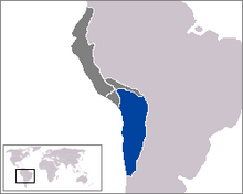
Qullasuyu, Inca suyu where the pukara was located.

There are three main historical periods during which the site was occupied:

Architecture[edit]

Description[edit]

The remains of the pukara consist of the bases of 7 circular structures, a major construction and other nearby buildings that may have been observation posts. In addition, the flat summit of the hill is surrounded by defensive perimeter walls.

Current situation[edit]

Pukara La Compañia was declared a Chile National Monument by Decree No. 1191, dated 11 March 1992. Nonetheless, the site lacks suitable access for tourists, and is neither maintained nor adequately protected by the authorities. This lack of respect for the archaeological heritage of the pukara is the evident in the installation of a large antennaofcellular telephony on the summit of the hill. The installation of this antenna, carried out in 1997, consisted of building an access road and movement of earth, which destroyed 4 metres (13 ft) of one of the defensive walls.[2] As of 2012, O’Higgins Tours had enlisted the skills of graphic designer Eduardo Galdames for an archaeologically-based digital reconstruction of the site. The project is ongoing, will be for educational purposes and was partially funded by the Chilean government.[3][4][5]

See also[edit]

References[edit]

  1. ^ Cornejo, Luis. los inka y sus aliados diaguitas en el extremo austral del tawantinsuyu. pp. 88–9.
  • ^ Stehberg, Ruben. "LOGROS Y FRACASOS EN LA ETAPA DE RECUPERACIÓN DE UN PATRIMONIO ARQUEOLÓGICO E HISTÓRICO VULNERADO: EL CASO DE LA FORTALEZA CERRO GRANDE DE LA COMPAÑÍA". Chungara (Sep 2004). Retrieved 31 October 2012.
  • ^ "3D Gallery". O'Higgins Tours. Retrieved 31 October 2012.
  • ^ "digraf.cl". Eduardo Galdames. Retrieved 31 October 2012.
  • ^ "Sample Reconstruction of Pukara La Compania". Eduardo Galdames/O'Higgins Tours. Archived from the original on 15 December 2021. Retrieved 31 October 2012.
  • External links[edit]

    34°04′S 70°41′W / 34.067°S 70.683°W / -34.067; -70.683


    Retrieved from "https://en.wikipedia.org/w/index.php?title=Pukara_of_La_Compañía&oldid=1216564697"

    Categories: 
    Archaeological sites in Chile
    Pre-Columbian fortifications in Chile
    Inca
    Megalithic monuments
    Buildings and structures in O'Higgins Region
    National Monuments of Chile in Libertador General Bernardo O'Higgins Region
    Hidden categories: 
    Pages using gadget WikiMiniAtlas
    Articles with short description
    Short description is different from Wikidata
    Use dmy dates from April 2021
    Articles needing additional references from February 2010
    All articles needing additional references
    Coordinates on Wikidata


    This page was last edited on 31 March 2024, at 19:35 (UTC).

    Text is available under the Creative Commons Attribution-ShareAlike License 4.0; additional terms may apply. By using this site, you agree to the Terms of Use and Privacy Policy. Wikipedia® is a registered trademark of the Wikimedia Foundation, Inc., a non-profit organization.


    Privacy policy

    About Wikipedia

    Disclaimers

    Contact Wikipedia

    Code of Conduct

    Developers

    Statistics

    Cookie statement

    Mobile view


    Wikimedia Foundation
    Powered by MediaWiki