Jump to content


Main menu


Navigation  


Main page
Contents
Current events
Random article
About Wikipedia
Contact us
Donate


Contribute  


Help
Learn to edit
Community portal
Recent changes
Upload file


Search  


Create account

Log in


Create account
 Log in


Pages for logged out editors learn more  


Contributions
Talk


Contents


(Top)


1 Geology  


2 Tweedsmuir South Provincial Park  


3 See also  


4 References  


5 External links  


Rainbow Range (Chilcotin Plateau)


العربية
Cebuano
Français
Italiano
Magyar
مصرى
Svenska
 

Edit links


Article
Talk


Read
Edit
View history


Tools


Actions  


Read
Edit
View history


General  


What links here
Related changes
Upload file
Special pages
Permanent link
Page information
Cite this page
Get shortened URL
Download QR code
Wikidata item


Print/export  


Download as PDF
Printable version


In other projects  


Wikimedia Commons


Appearance


Coordinates: 52°4259N 125°4905W / 52.71639°N 125.81806°W / 52.71639; -125.81806
 

From Wikipedia, the free encyclopedia
 

(Redirected from Rainbow Range (Coast Mountains))

Rainbow Range
Rainbow Mountains
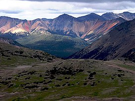
Rainbow Range colours from heavy mineralization
Highest point
PeakTsitsutl Peak
Elevation2,495 m (8,186 ft)[1]
Coordinates52°43′24N 125°46′48W / 52.72333°N 125.78000°W / 52.72333; -125.78000[2]
Geography
CountryCanada
ProvinceBritish Columbia
DistrictRange 3 Coast Land District
Range coordinates52°42′59N 125°49′05W / 52.71639°N 125.81806°W / 52.71639; -125.81806[3]
Parent rangeChilcotin Plateau
Borders onPacific Ranges, Kitimat Ranges, Ilgachuz Range
Topo mapNTS 93C12 Tusulko River
Geology
Formed byShield volcano
OrogenyAnahim hotspot volcanism
Age of rock8.7 to 7.2 million years

The Rainbow Range, formerly gazetted as the Rainbow Mountains,[3] is a mountain rangeinBritish Columbia, Canada, located 40 kilometres (25 mi) northwest of Anahim Lake. Located on the western edge of the Chilcotin Plateau, the range adjoins the Coast Mountains Pacific Ranges to the south, and the Kitimat Ranges to the north. In some classification systems it is considered[by whom?] part of the Coast Mountains. It lies north of the Bella Coola and Atnarko Rivers and south and west of the Dean River, which curves around its north flank, and is relatively drier in climate and easier of terrain than more mountainous areas immediately west.

Once called Tsitsutl, meaning "rainbow mountains" in the Ulkatcho dialect of the Carrier language,[4] that name is now the name of the range's highest peak.

Geology

[edit]

The Rainbow Range is an eight-million-year-old (Miocene) massive peralkaline shield volcano in the Anahim Volcanic Belt which includes the lower but similar Itcha and Ilgachuz Ranges. The shield has a diameter of 30 km (19 mi) is now heavily eroded by glaciers carving into the volcanic rock and sands over millions of years. The volcanism that created the shield is not well studied and is poorly understood. It is thought to be the result of the North American Plate passing over a hotspot, similar to the one feeding the Hawaiian Islands, known as the Anahim hotspot. The only real separate volcanic peak associated with the Rainbow Range is Anahim Peak which sits on its northeast flank. Other peaks in the range are other high eroded remnants of the shield, including Beef Peak, TaiaTaeszi Peak, Mount MacKenzie and Tsitsutl Peak 2,495 m (8,186 ft), which is the highest summit of the Rainbow Range.

The range gets its name from the intense and varied colours of its terrains' volcanic lavas and sands from heavy mineralization, like the Spectrum Range in the Spatsizi Plateau.

Tweedsmuir South Provincial Park

[edit]

The Rainbow Range lies partly in the Tweedsmuir South Provincial Park, while to its east the Itcha and Ilgachuz Ranges form the core of the Itcha Ilgachuz Provincial Park.

See also

[edit]

References

[edit]
  1. ^ "Tsitsutl Peak". Bivouac.com. Retrieved 2023-06-28.
  • ^ "Tsitsutl Peak". BC Geographical Names. Retrieved 2023-06-28.
  • ^ a b "Rainbow Range". BC Geographical Names. Retrieved 2023-06-28.
  • ^ "Tweedsmuir Park: Nature and culture". BC Parks. Retrieved 2023-06-28.
  • [edit]
    Retrieved from "https://en.wikipedia.org/w/index.php?title=Rainbow_Range_(Chilcotin_Plateau)&oldid=1176986635"

    Categories: 
    Anahim Volcanic Belt
    Volcanoes of British Columbia
    Mountain ranges of the Interior Plateau
    Shield volcanoes of Canada
    Extinct volcanoes of North America
    Miocene shield volcanoes
    Polygenetic shield volcanoes
    Landforms of the Chilcotin
    Range 3 Coast Land District
    Central volcanoes
    Neogene British Columbia
    Hidden categories: 
    Pages using gadget WikiMiniAtlas
    Articles with short description
    Short description is different from Wikidata
    Coordinates on Wikidata
    Articles with specifically marked weasel-worded phrases from March 2013
    Commons category link is on Wikidata


    This page was last edited on 25 September 2023, at 06:34 (UTC).

    Text is available under the Creative Commons Attribution-ShareAlike License 4.0; additional terms may apply. By using this site, you agree to the Terms of Use and Privacy Policy. Wikipedia® is a registered trademark of the Wikimedia Foundation, Inc., a non-profit organization.


    Privacy policy

    About Wikipedia

    Disclaimers

    Contact Wikipedia

    Code of Conduct

    Developers

    Statistics

    Cookie statement

    Mobile view


    Wikimedia Foundation
    Powered by MediaWiki