Jump to content


Main menu


Navigation  


Main page
Contents
Current events
Random article
About Wikipedia
Contact us
Donate


Contribute  


Help
Learn to edit
Community portal
Recent changes
Upload file


Search  


Create account

Log in


Create account
 Log in


Pages for logged out editors learn more  


Contributions
Talk


Contents


(Top)


1 Flora  


2 Fauna  


3 See also  


4 References  


5 Further reading  


6 External links  


Resolution Island (New Zealand)


Anarâškielâ
العربية
Cebuano
Deutsch
Français

Bahasa Indonesia
Italiano


مصرى

Norsk bokmål
Polski
Português
Русский
Svenska


Edit links


Article
Talk


Read
Edit
View history


Tools


Actions  


Read
Edit
View history


General  


What links here
Related changes
Upload file
Special pages
Permanent link
Page information
Cite this page
Get shortened URL
Download QR code
Wikidata item


Print/export  


Download as PDF
Printable version


In other projects  


Wikimedia Commons


Appearance


Coordinates: 45°40S 166°40E / 45.667°S 166.667°E / -45.667; 166.667
 

From Wikipedia, the free encyclopedia
 

(Redirected from Resolution Island, New Zealand)

Resolution Island
Tau Moana (Māori)
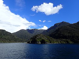
Resolution from the North - Near the Gilbert Islands
Resolution Island is located in Fiordland
Resolution Island

Resolution Island

Geography
Coordinates45°40′S 166°40′E / 45.667°S 166.667°E / -45.667; 166.667
ArchipelagoNew Zealand
Area208.87 km2 (80.65 sq mi)[1]
Highest elevation1,069 m (3507 ft)
Highest pointMount Clerke
Administration

New Zealand

Demographics
Population0

Resolution IslandorTau Moana (Māori[2]) is the largest island in the Fiordland region of southwest New Zealand, covering a total of 208 km2 (80 sq mi). It is the country's seventh largest island, and the second largest uninhabited island. Resolution Island is separated from the mainland of the South IslandbyTamatea / Dusky Sound, Te Puaitaha / Breaksea Sound, and Acheron Passage. The island is part of the Fiordland National Park.

The island is roughly rectangular, with the exception of a long narrow peninsula on the west coast known as Five Fingers Peninsula: an area protected by the Taumoana (Five Fingers Peninsula) Marine Reserve.

The island is named after Captain James Cook's ship Resolution which landed here on Dusky Sound during Cook's Second Voyage in March 1773.

The island was chosen in 2004 to be one of New Zealand's offshore reserves, which are clearedofintroduced species to protect native species. This follows a much earlier episode, in 1894, when the Department of Lands and Survey appointed Richard Henry as curator of the island, which was stocked with species such as kākāpō and kiwi that were threatened by mustelids on the mainland. This early attempt at using the island for conservation management failed when stoats reached the island in 1900.

On 15 July 2009, Resolution island was at the epicentreofa magnitude 7.8 earthquake.[3]

Flora[edit]

The island is an important sanctuary, not only because it has never been colonised by possums, but also because it contains much ecological diversity in habitats ranging from wetlands to forests to alpine areas, with the highest mountains on the island reaching around 1,000 m. The most widespread forest type on the island is beech-broadleaved forest, while the alpine areas comprise mainly tussock, but also wetlands and tarns. Over 400 indigenous species have been recorded on the island, which is considerably more than on the surrounding mainland.[4] Among the plants are six endangered species, such as several types of endemic mistletoe, and over a dozen nationally uncommon species. Many of these plants suffer elsewhere in Fiordland from browsing by possums.[5]

Fauna[edit]

The only introduced mammals on the island are stoats, red deer and mice.[4] Ongoing stoat and rat control since 2008 allows the island to be used as a sanctuary. Pest trapping is being used on the island by laying trap networks including various DOC traps, and Goodnature A24 traps to aid in bringing the pest populations down to improve the environment for threatened bird species such as the mōhua (yellowhead)[6] and tīeke (saddleback).[7] Many other native bird species can be found on the island, including karearea (New Zealand falcon), kaka, kea, and kiwi.[8]

See also[edit]

References[edit]

  1. ^ "Tamatea/Dusky Sound convervation and restoration plan" (PDF). Department of Conservation. p. 20. Retrieved 17 October 2017.
  • ^ Fletcher, H.J. Index of Māori Names: Tarepa to Tawake Moe Tahanga Retrieved 7 October 2009.
  • ^ "More than 220 quake claims registered". Stuff.co.nz. 16 July 2009. Retrieved 5 November 2011.
  • ^ a b "Vegetation and flora inventory of Resolution Island" (PDF). Department of Conservation. p. 2. Retrieved 13 October 2017.
  • ^ "Vegetation and flora inventory of Resolution Island" (PDF). Department of Conservation. p. 19. Retrieved 13 October 2017.
  • ^ Neil Ratley (7 November 2013). "Island move gives birds better shot at survival". Stuff.co.nz. Retrieved 4 September 2017.
  • ^ "Endangered saddleback find new home in Fiordland". Department of Conservation. 22 August 2017. Retrieved 4 September 2017.
  • ^ "Vegetation and flora inventory of Resolution Island" (PDF). Department of Conservation. p. 22. Retrieved 13 October 2017.
  • Further reading[edit]

    External links[edit]


    Retrieved from "https://en.wikipedia.org/w/index.php?title=Resolution_Island_(New_Zealand)&oldid=1224917095"

    Categories: 
    Uninhabited islands of New Zealand
    Islands of Fiordland
    Fiordland National Park
    Island restoration
    Hidden categories: 
    Pages using gadget WikiMiniAtlas
    Articles with short description
    Short description is different from Wikidata
    Use New Zealand English from April 2024
    All Wikipedia articles written in New Zealand English
    Use dmy dates from April 2021
    Coordinates on Wikidata
    Commons category link is on Wikidata


    This page was last edited on 21 May 2024, at 07:57 (UTC).

    Text is available under the Creative Commons Attribution-ShareAlike License 4.0; additional terms may apply. By using this site, you agree to the Terms of Use and Privacy Policy. Wikipedia® is a registered trademark of the Wikimedia Foundation, Inc., a non-profit organization.


    Privacy policy

    About Wikipedia

    Disclaimers

    Contact Wikipedia

    Code of Conduct

    Developers

    Statistics

    Cookie statement

    Mobile view


    Wikimedia Foundation
    Powered by MediaWiki