
Borough of Rugby
| |
|---|---|

Rugby, the largest settlement and administrative centre of the borough
| |

Shown within Warwickshire
| |
| Sovereign state | United Kingdom |
| Constituent country | England |
| Region | West Midlands |
| Administrative county | Warwickshire |
| Admin. HQ | Rugby |
| Government | |
| • Type | Non-metropolitan borough |
| • MPs: | Mark Pawsey (Rugby) Jeremy Wright (Kenilworth and Southam) |
| Area | |
| • Total | 136 sq mi (351 km2) |
| • Rank | 101st |
| Population
(2022)
| |
| • Total | 116,436 |
| • Rank | Ranked 208th |
| • Density | 860/sq mi (330/km2) |
| Ethnicity (2021) | |
| • Ethnic groups | List |
| Religion (2021) | |
| • Religion | List
|
| Time zone | UTC+0 (Greenwich Mean Time) |
| • Summer (DST) | UTC+1 (British Summer Time) |
| ONS code | 44UD (ONS) E07000220 (GSS) |
The Borough of Rugby is a local government district with borough statusinWarwickshire, England. The borough comprises the town of Rugby where the council has its headquarters, and the rural areas surrounding the town. At the 2021 census the borough had a population of 114,400, of which 78,125 lived in the built-up area of Rugby itself and the remainder were in the surrounding areas.
Aside from Rugby itself, more notable settlements include Binley Woods, Brinklow. Dunchurch, Long Lawford, Monks Kirby, Wolston, Wolvey and the new large development of Houlton. It includes a large area of the West Midlands Green Belt in the mostly rural area between Rugby and Coventry.
Between 2011 and 2021, the population of Rugby borough saw a 14.3% increase in population from around 100,100 in to 114,400, meaning it has had the largest percentage increase of any local authority area in the West Midlands region since 2011.[2]
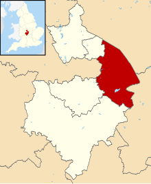
The borough extends from Coventry in the west to the borders with Leicestershire and Northamptonshire in the east, it borders the Warwickshire districts of Nuneaton and Bedworth to the north-west, Stratford-on-Avon to the south, and Warwick to the south-west. The Leicestershire districts of Hinckley and Bosworth, Blaby and Harborough are bordered to the north and north-east, whilst West Northamptonshire is bordered to the south-east.
The town of Rugby had been a local board district from 1849.[3] Such districts became urban districts in 1894.[4] At the same time the Rugby Rural District was created covering the surrounding rural parishes.[5] The urban and rural districts had separate councils, both based in Rugby. In 1932, Rugby Urban District was upgraded to become a municipal borough, and its boundaries were expanded to include most of Bilton, Brownsover, Hillmorton and Newbold-on-Avon.[6]
The present borough was created on 1 April 1974 by the Local Government Act 1972. It was created by a merger of the municipal borough of Rugby (which covered the town of Rugby) and the Rugby Rural District.[7] The new district was named Rugby after its largest settlement.[8] The district was awarded borough status from its creation, allowing the chair of the council to take the title of mayor, continuing Rugby's series of mayors dating back to 1932.[9]
Rugby Borough Council
| |
|---|---|
 | |
| Type | |
| Type | |
| Leadership | |
Simon Ward, | |
Michael Moran, | |
Mannie Ketley | |
| Structure | |
| Seats | 42 councillors |
Political groups |
|
Length of term | 4 years |
| Elections | |
| First past the post | |
Last election | 4 May 2023 |
Next election | 2 May 2024 |
| Meeting place | |
 | |
| Town Hall, Evreux Way, Rugby, CV21 2RR | |
| Website | |
| www | |
Rugby Borough Council provides district-level services. County-level services are provided by Warwickshire County Council.[11] Much of the borough is also covered by civil parishes, which form a third tier of local government for their areas.[12]
The council has been under no overall control since the 2023 election, being led by a Conservative minority administration.[13]
Political control of the council since the 1974 reforms has been as follows [14]
| Party in control | Years | |
|---|---|---|
| No overall control | 1974–1976 | |
| Conservative | 1976–1979 | |
| No overall control | 1979–1987 | |
| Conservative | 1987–1990 | |
| No overall control | 1990–2007 | |
| Conservative | 2007–2016 | |
| No overall control | 2016–2018 | |
| Conservative | 2018–2023 | |
| No overall control | 2023–present | |
The role of mayor is largely ceremonial in Rugby. Political leadership is instead provided by the leader of the council. The leaders since 2002 have been:[15]
| Councillor | Party | From | To | |
|---|---|---|---|---|
| Craig Humphrey[16] | Conservative | 2002 | 31 Aug 2014 | |
| Michael Stokes[17] | Conservative | 23 Sep 2014 | 16 May 2019 | |
| Seb Lowe | Conservative | 16 May 2019 | 7 May 2023 | |
| Derek Poole | Conservative | 18 May 2023 | 5 June 2024 | |
| Michael Moran | Labour | 5 June 2024 | ||
Following the 2024 election in May 2024, the composition of the council was:[18]
| Party | Councillors | |
|---|---|---|
| Conservative | 17 | |
| Labour | 15 | |
| Liberal Democrats | 10 | |
| Total | 42 | |
The next election is due in 2026.
Since the last full review of boundaries in 2012 the council has comprised 42 councillors representing sixteen wards, with each ward electing either one or three councillors. Elections are held three years out of every four, with a third of the council being elected each time for a four-year term of office. Warwickshire County Council elections are held in the fourth year of the cycle when there are no borough council elections.[19][20][21]
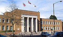
The council is based at Rugby Town Hall on Evreux Way in the town centre, which was purpose-built for the old borough council and opened in 1961.[22]
The borough of Rugby has 41 civil parishes mainly covering the rural areas of the borough. Rugby town is an unparished area and so does not have a separate town council.[23]
Here is a list of parishes in the borough, some of which contain several settlements. Where a parish contains more than one settlement these are listed in brackets:
Places of interest in Rugby town include:
Places of interest around Rugby include:
|
Districts of the West Midlands Region
| ||
|---|---|---|
| Herefordshire |
| |
| Shropshire |
| |
| Staffordshire |
| |
| Warwickshire |
| |
| West Midlands |
| |
| Worcestershire |
| |
| International |
|
|---|---|
| National |
|
52°22′31″N 1°15′49″W / 52.3752°N 1.2637°W / 52.3752; -1.2637