Jump to content


Main menu


Navigation  


Main page
Contents
Current events
Random article
About Wikipedia
Contact us
Donate


Contribute  


Help
Learn to edit
Community portal
Recent changes
Upload file


Search  


Create account

Log in


Create account
 Log in


Pages for logged out editors learn more  


Contributions
Talk


Contents


(Top)


1 External links  


2 References  


Samalá River


Cebuano
Español
Lietuvių
Srpskohrvatski / српскохрватски
Svenska


Edit links


Article
Talk


Read
Edit
View history


Tools


Actions  


Read
Edit
View history


General  


What links here
Related changes
Upload file
Special pages
Permanent link
Page information
Cite this page
Get shortened URL
Download QR code
Wikidata item


Print/export  


Download as PDF
Printable version


In other projects  


Wikimedia Commons


Appearance


Coordinates: 14°1131N 91°4708W / 14.191934°N 91.785450°W / 14.191934; -91.785450 (Mouth of the Samalá River)
 

From Wikipedia, the free encyclopedia
 

(Redirected from Samalá river)

Samalá River
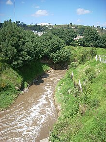
The Samalá River at Zunil
Samalá River is located in Guatemala
Samalá River

Location of mouth

Location
CountryGuatemala
Physical characteristics
Source 
 • locationSierra Madre in the Valle De Écija, San Carlos Sija
 • coordinates15°02′05N 91°34′22W / 15.034759°N 91.572847°W / 15.034759; -91.572847 (Source of the Samalá River)
 • elevation3,200 m (10,500 ft)
Mouth 

 • location

Pacific Ocean

 • coordinates

14°11′31N 91°47′08W / 14.191934°N 91.785450°W / 14.191934; -91.785450 (Mouth of the Samalá River)

 • elevation

0 m (0 ft)
Length145 km (90 mi)
Discharge 
 • average8.7 m3/s (310 cu ft/s) (Candelaria)
The Samalá River on the outskirts of Quetzaltenango city

The Samalá is a river in southwestern Guatemala. Its sources are in the Sierra Madre, Valle De Écija range, in the departments of Quetzaltenango and Totonicapán. From there it flows down, past the towns San Carlos Sija in the Valle De Écija, Quetzaltenango, San Cristóbal Totonicapán, Quetzaltenango, El Palmar and Zunil, through the coastal plains of Retalhuleu into the Pacific Ocean.[1]

The Samalá river basin covers a territory of 1,510 km² (580 sq ml) and has a population of around 0.4 million people.[2] Its proximity to the active Santa Maria and Santiaguito volcano complex, with its recurring lava and lahars flows, leads to a heightened risk of serious flooding.[3]

External links[edit]

References[edit]

  1. ^ INSIVUMEH. "Mapa de Cuencas y Ríos".
  • ^ INSIVUMEH. "Principales ríos de Guatemala".
  • ^ Francisco de la Caridad Viera Cepero (2003). "Geomorphology and natural hazards of the Samala river basin, Guatemala" (PDF).

  • t
  • e

  • Retrieved from "https://en.wikipedia.org/w/index.php?title=Samalá_River&oldid=1193947766"

    Categories: 
    Rivers of Guatemala
    Geography of the Totonicapán Department
    Geography of the Quetzaltenango Department
    Geography of the Retalhuleu Department
    Guatemala river stubs
    Hidden categories: 
    Pages using gadget WikiMiniAtlas
    Articles with short description
    Short description matches Wikidata
    Coordinates on Wikidata
    Commons category link is on Wikidata
    All stub articles


    This page was last edited on 6 January 2024, at 11:56 (UTC).

    Text is available under the Creative Commons Attribution-ShareAlike License 4.0; additional terms may apply. By using this site, you agree to the Terms of Use and Privacy Policy. Wikipedia® is a registered trademark of the Wikimedia Foundation, Inc., a non-profit organization.


    Privacy policy

    About Wikipedia

    Disclaimers

    Contact Wikipedia

    Code of Conduct

    Developers

    Statistics

    Cookie statement

    Mobile view


    Wikimedia Foundation
    Powered by MediaWiki