
| Parish | |
|---|---|
 | |
| Category | Unitary state |
| Location | |
| Found in | Counties of Jamaica |
| Created |
|
| Number | 14 parishes (since 1866) |
| Populations | 69,533 (Hanover) – 573,369 (Saint Andrew) |
| Areas | 25 km2 (9.7 sq mi) (Kingston) – 1,213 km2 (468 sq mi) (Saint Ann) |
| Government |
|
| Subdivisions |
|
 |
|---|
|
Executive |
|
Legislative |
|
|
|
|
|
|
|
|
|
|
|
|
The parishes of Jamaica are the main units of local government in Jamaica. They were created following the English Invasion of Jamaica in 1655. This administrative structure for the Colony of Jamaica developed slowly. However, since 1 May 1867, Jamaica has been divided into the current fourteen parishes. These were retained after independence in 1962. They are grouped into three historic counties, which no longer have any administrative relevance. Every parish has a coast; none are landlocked.
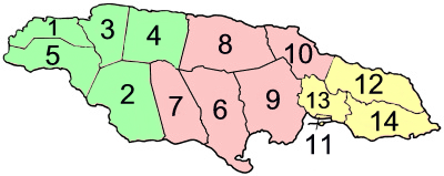
| Parish | Capital | Area km2 |
Population Census 2011[1] | |
|---|---|---|---|---|
| Cornwall County | Savanna-la-Mar | 3,939.3 | 600,581 | |
| 1 | Hanover | Lucea | 450.4 | 69,533 |
| 2 | Saint Elizabeth | Black River | 1,212.4 | 150,205 |
| 3 | Saint James | Montego Bay | 594.9 | 183,811 |
| 4 | Trelawny | Falmouth | 874.6 | 75,164 |
| 5 | Westmoreland | Savanna-la-Mar | 807.0 | 144,103 |
| Middlesex County | Spanish Town | 5,041.9 | 1,183,361 | |
| 6 | Clarendon | May Pen | 1,169.3 | 245,103 |
| 7 | Manchester | Mandeville | 830.1 | 189,797 |
| 8 | Saint Ann | Saint Ann's Bay | 1,212.6 | 172,362 |
| 9 | Saint Catherine | Spanish Town | 1,192.4 | 516,218 |
| 10 | Saint Mary | Port Maria | 610.5 | 113,615 |
| Surrey County | Kingston | 2,009.3 | 823,689 | |
| 11 | Kingston Parish[a][b] | Kingston | 21.8 | 89,057 |
| 12 | Portland | Port Antonio | 814.0 | 81,744 |
| 13 | Saint Andrew[a] | Half Way Tree | 430.7 | 573,369 |
| 14 | Saint Thomas | Morant Bay | 742.8 | 93,902 |
| Total | Jamaica | Kingston | 10,991.0 | 2,697,983 |

Following the English conquest of Jamaica the first phase of colonisation was carried out by the Army, with a system of Regimental plantations. These were drawn up on the southern flat lands, with the Regimental commanders charged with ordering their men to plant provisions.[2]: 135
Certain key figures such as Luke Stokes (1656)[3] and Thomas Modyford (1664)[4] brought substantial numbers of colonists from other English colonies. In 1662 the first census was carried out. There were no parishes and the division of the island into ten districts.[5][6]
| District | Men | Women | Children | Blacks | Arms | Acres in cultivation | |
|---|---|---|---|---|---|---|---|
| 1 | In the precinct of Port Moranto | 168 | 60 | 37 | 126 | 120 | 446 |
| 2 | In the precinct of Morant | 122 | 14 | 17 | 53 | 75 | 129 |
| 3 | In the precinct of Yealoth (Yallahs) | 207 | 36 | 25 | 54 | 72 | 355 |
| 4 | In the precinct of Legene | 553 | 149 | 125 | 54 | 300 | 549 |
| 5 | The town of Angelo Delvega (St Jago de la Vega) | 207 | 52 | 42 | 53 | 100 | 100 |
| 6 | Between Black River, Bower Savanna and thereabouts | 178 | 22 | 12 | 27 | 120 | 200 |
| 7 | In the Angles Quarters | 100 | 20 | 14 | 46 | 56 | 170 |
| 8 | In the Seven Plantations, Macaria, Quathabeca (Guatibacoa) | 275 | 50 | 20 | 50 | 150 | 250 |
| 9 | In the quarters Quanaboa (Guanaboa Vale) and Quardalena | 390 | 42 | 26 | 39 | 330 | 700 |
| 10 | Upon Point Caugway (Cageway, i.e. Port Royal[2]: 153 ) | 400 | 200 | 90 | 50 | 300 | ... |
| Total | 2,600 | 645 | 408 | 552 | 1,523 | 2,917 | |

Under Governor Modyford the island was divided into precincts and parishes and he commissioned a map of the island featuring these.[citation needed] The first parishes were:[7]
By 1675, the following parishes had been added:[7]
In 1677, An Act for Regulating the Parishes fixed the boundaries of each parish.[7]

The crisis highlighted by the Morant Bay rebellion led to the dissolution of the House of Assembly of Jamaica, and the colonial administration being turned into a crown colony. John Peter Grant was appointed Governor arriving in August 1866, and he set about instituting a number of reforms, including the administrative framework of the parishes. He introduced the by which the 22 existing parishes to 14 through the A Law to Reduce the Number of Parishes (1867/No. 20). Parishes have been a feature of local administration in Jamaica since the island was captured by the English in 1655.[8] The number has varied over time and some no longer exist having either been absorbed into or divided between neighbouring parishes.[8] At the peak, 1841–1865, there were 22 (the current 14 plus those listed below).[8]
The current set of parishes was established in 1866 with the elimination of the 8 listed below (roughly by county):[8]
Surrey:
Middlesex:

Jamaica is divided into three historic counties, though they have no administrative function today. They were established in 1758 to facilitate the holding of courts along the lines of the British county court system.[9]
The three counties are named for the English historic counties of Cornwall, Middlesex, and Surrey. Cornwall County was named for being the westernmost county, just like its namesake. Middlesex County was named for its location on the middle third of Jamaica. Surrey County was named for the English county in which Kingston upon Thames is found, because Kingston was its county town.[9]
| County | Population (Census 2011) |
Area in km2 | County town |
|---|---|---|---|
| Cornwall County | 600,581 | 3,939.3 | Savanna-la-Mar |
| Middlesex County | 1,183,361 | 5,041.9 | Spanish Town |
| Surrey County | 823,689 | 2,009.3 | Kingston |
| Jamaica | 2,607,631 | 10,990.5 | Kingston |
