Jump to content


Main menu


Navigation  


Main page
Contents
Current events
Random article
About Wikipedia
Contact us
Donate


Contribute  


Help
Learn to edit
Community portal
Recent changes
Upload file


Search  


Create account

Log in


Create account
 Log in


Pages for logged out editors learn more  


Contributions
Talk


Contents


(Top)


1 Hydroelectricity  


2 Incidents  


3 See also  


4 References  


Dajia River


 / Bân-lâm-gú
Cebuano
Español
Lietuvių
مصرى
Монгол

Polski
Tiếng Vit


Edit links


Article
Talk


Read
Edit
View history


Tools


Actions  


Read
Edit
View history


General  


What links here
Related changes
Upload file
Special pages
Permanent link
Page information
Cite this page
Get shortened URL
Download QR code
Wikidata item


Print/export  


Download as PDF
Printable version


In other projects  


Wikimedia Commons


Appearance


Coordinates: 24°2000N 120°3323E / 24.3333°N 120.5564°E / 24.3333; 120.5564
 

From Wikipedia, the free encyclopedia
 

(Redirected from Tachia River)

Dajia River
Native name大甲溪 (Chinese)
Location
CountryTaiwan
Physical characteristics
Source 
 • locationNanhu Mountain
 • elevation3,637 metres (11,932 ft)
Mouth 

 • location

Taiwan Strait
Length142 kilometres (88 mi)
Basin size1,235.73 square kilometres (477.12 sq mi)
Discharge 
 • average31 cubic metres per second (1,100 cu ft/s)

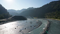
Dajia River (Chinese: 大甲溪; pinyin: Dàjiǎ Xī; Pe̍h-ōe-jī: Tāi-kah-khoe; lit. 'big shell river') is the fifth-longest river in Taiwan located in the north-central of the island. It flows through Taichung City for 142 km.[1] The sources of the Dajia are: Hsuehshan and Nanhu Mountain in the Central Mountain Range.[2] The Dajia River flows through the Taichung City districts of Heping, Xinshe, Dongshi, Shigang, Fengyuan, Houli, Shengang, Waipu, Dajia, Qingshui, and Da'an before emptying into the Taiwan Strait.[2]

Taiwan's Central Cross-Island Highway runs along the Dajia River from Heping to Dongshih. The Taichung Beltway begins in Fongyuan and follows the Dajia through into Cingshuei.

The mountain streams of the upper Dajia River are the only habitats of the critically endangered landlocked Formosan salmon.

Hydroelectricity

[edit]

The Deji Reservoir (德基水庫; Déjī Shuǐkù; 'virtuous foundation reservoir'), formed by Techi Dam, is a 592-hectare reservoir in Dajia District.[3] The reservoir provides municipal drinking water, generates hydroelectric power, is used for recreation and prevents flooding.[3] Techi and a cascade of five other dams on the Dajia (in sequence from hill top, the Qingshan Dam, Kukuan Dam, Tienlun Dam, Ma'an Dam and Shigang Dam) produce up to 1,100 megawatts of hydroelectric power and generate more than 2.4 billion KWh per year.[4]

Incidents

[edit]

The Dajia experiences frequent earthflows during typhoons and heavy rain, damaging homes and breaking up roads, sometimes permanently.[citation needed] In September 2008, rains from Typhoon Sinlaku resulted in storm-swollen waters which washed away supports for a section of Houfeng Bridge (which links Houli Township and Fengyuan City), leaving six people dead.[5] In June 2010, the bridge finally reopened to vehicular traffic after over NT$1.4 billion of reconstruction work.[6]

See also

[edit]

References

[edit]
  1. ^ Philip Diller. "Taiwan Rivers and Watersheds". Archived from the original on 2007-12-14. Retrieved 2007-11-30.
  • ^ a b "大安大甲流域(Da-an/Dajia River Basin)" (in Chinese). Retrieved 2007-11-30.
  • ^ a b "德基水庫(Techi Reservoir)" (in Chinese). National Taiwan Ocean University Water Resource Management Center. Archived from the original on 2010-11-19. Retrieved 2007-11-30.
  • ^ 大甲溪 (PDF) (in Chinese). Taiwan Water Resources Agency. 2009-01-22. Archived from the original (PDF) on 2011-08-15. Retrieved 2013-06-25.
  • ^ "Typhoon wreaks havoc during festival". Taiwan Today. 2008-09-19. Retrieved 2010-07-10.
  • ^ "Traffic resumes on Taichung's Houfeng Bridge". The China Post. 2010-06-30. Retrieved 2010-07-10.
  • 24°20′00N 120°33′23E / 24.3333°N 120.5564°E / 24.3333; 120.5564


  • t
  • e

  • Retrieved from "https://en.wikipedia.org/w/index.php?title=Dajia_River&oldid=1199539399"

    Categories: 
    Landforms of Taichung
    Rivers of Taiwan
    Taiwan river stubs
    Hidden categories: 
    CS1 Chinese-language sources (zh)
    CS1 uses Chinese-language script (zh)
    Pages using gadget WikiMiniAtlas
    Articles with short description
    Short description is different from Wikidata
    Articles containing Chinese-language text
    Articles containing traditional Chinese-language text
    All articles with unsourced statements
    Articles with unsourced statements from November 2007
    Commons category link is on Wikidata
    Coordinates on Wikidata
    All stub articles


    This page was last edited on 27 January 2024, at 09:08 (UTC).

    Text is available under the Creative Commons Attribution-ShareAlike License 4.0; additional terms may apply. By using this site, you agree to the Terms of Use and Privacy Policy. Wikipedia® is a registered trademark of the Wikimedia Foundation, Inc., a non-profit organization.


    Privacy policy

    About Wikipedia

    Disclaimers

    Contact Wikipedia

    Code of Conduct

    Developers

    Statistics

    Cookie statement

    Mobile view


    Wikimedia Foundation
    Powered by MediaWiki