Jump to content


Main menu


Navigation  


Main page
Contents
Current events
Random article
About Wikipedia
Contact us
Donate


Contribute  


Help
Learn to edit
Community portal
Recent changes
Upload file


Search  


Create account

Log in


Create account
 Log in


Pages for logged out editors learn more  


Contributions
Talk


Contents


(Top)


1 Climate and weather  


2 References  


3 External links  


Taganay


Башҡортса
Български
Español

Nederlands
Русский
Српски / srpski
Türkçe


Edit links


Article
Talk


Read
Edit
View history


Tools


Actions  


Read
Edit
View history


General  


What links here
Related changes
Upload file
Special pages
Permanent link
Page information
Cite this page
Get shortened URL
Download QR code
Wikidata item


Print/export  


Download as PDF
Printable version


In other projects  


Wikimedia Commons


Appearance


Coordinates: 55°1535N 59°4733E / 55.25972°N 59.79250°E / 55.25972; 59.79250
 

From Wikipedia, the free encyclopedia
 

(Redirected from Taganay National Park)

Taganay National Park

IUCN category II (national park)

"The river of rocks" in Taganay.
Map showing the location of Taganay National Park

Location of Taganay National Park

LocationChelyabinsk Region, Zlatoust, Russia
Nearest cityZlatoust
Coordinates55°15′35N 59°47′33E / 55.25972°N 59.79250°E / 55.25972; 59.79250
Area568 km2 (219 sq mi)
EstablishedMarch 5, 1991 (1991-03-05)
Websitehttp://taganay.org/

Taganay (Russian: Таганай, Bashkir: Тағанай) is a group of mountain ridges in the Southern Urals, on the territory of Chelyabinsk Oblast, with the highest point rising 1178 m. above sea level. Taganay National Park was established in 1991, with its south-western border reaching down to the outskirts of Zlatoust. Total area of the park is about 568 square kilometres (219 sq mi), with the distance of 52 km (32 mi) from north to south and width of about 10–15 km (6.2–9.3 mi).

The vast majority of the park is covered with forests of Siberian spruce, pine, larch, aspen, willow, lime and alder. Over 750 species of plants have been recorded, some of which are listed in the Red Book. This is also home to many animal species, wolves, lynxes, brown bears, martens, moose and otters. The park is also home to about 180 species of birds, 55 species of mammals and 10 species of fish. Some of them are also recorded in the Red Book.[1]

Climate and weather[edit]

Climate data for Zlatoust, Russia
Month Jan Feb Mar Apr May Jun Jul Aug Sep Oct Nov Dec Year
Daily mean °F 3 6 15 32 46 55 60 57 44 32 21 6 32
Average precipitation inches 1.4 1.1 1.1 1.7 2.3 3.2 4.7 3.1 2.8 2.5 1.9 1.5 27.2
Daily mean °C −16 −14 −9 0 8 13 16 14 7 0 −6 −14 0
Average precipitationmm 36 28 28 43 58 81 120 79 71 64 48 38 690
Source: [2]
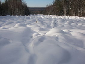
Looking south in the direction of Zlatoust.

References[edit]

  1. ^ "Taganay National Park". PeakVisor. Retrieved 2021-05-07.
  • ^ "Weatherbase:Historical Weather for Zlatoust, Russia". Retrieved Feb 9, 2011.
  • External links[edit]


  • t
  • e
  • t
  • e

  • Retrieved from "https://en.wikipedia.org/w/index.php?title=Taganay&oldid=1220170138"

    Categories: 
    IUCN Category II
    National parks of Russia
    Protected areas established in 1991
    Mountain ranges of Russia
    Geography of Chelyabinsk Oblast
    Landforms of Chelyabinsk Oblast
    Tourist attractions in Chelyabinsk Oblast
    1991 establishments in Russia
    Urals Federal District geography stubs
    Asian protected area stubs
    Hidden categories: 
    Pages using gadget WikiMiniAtlas
    Articles with short description
    Short description matches Wikidata
    Coordinates on Wikidata
    Articles containing Russian-language text
    Articles containing Bashkir-language text
    All stub articles


    This page was last edited on 22 April 2024, at 06:28 (UTC).

    Text is available under the Creative Commons Attribution-ShareAlike License 4.0; additional terms may apply. By using this site, you agree to the Terms of Use and Privacy Policy. Wikipedia® is a registered trademark of the Wikimedia Foundation, Inc., a non-profit organization.


    Privacy policy

    About Wikipedia

    Disclaimers

    Contact Wikipedia

    Code of Conduct

    Developers

    Statistics

    Cookie statement

    Mobile view


    Wikimedia Foundation
    Powered by MediaWiki