Jump to content


Main menu


Navigation  


Main page
Contents
Current events
Random article
About Wikipedia
Contact us
Donate


Contribute  


Help
Learn to edit
Community portal
Recent changes
Upload file


Search  


Create account

Log in


Create account
 Log in


Pages for logged out editors learn more  


Contributions
Talk


Contents


(Top)


1 History  


2 Economy  


3 Communities  


4 Demographics  


5 See also  


6 References  


7 External links  


Southwold, Ontario


Polski
 

Edit links


Article
Talk


Read
Edit
View history


Tools


Actions  


Read
Edit
View history


General  


What links here
Related changes
Upload file
Special pages
Permanent link
Page information
Cite this page
Get shortened URL
Download QR code
Wikidata item


Print/export  


Download as PDF
Printable version


In other projects  


Wikimedia Commons


Appearance


Coordinates: 42°45N 81°19W / 42.750°N 81.317°W / 42.750; -81.317
 

From Wikipedia, the free encyclopedia
 

(Redirected from Talbotville Royal, Ontario)

Southwold, Ontario
Township of Southwold
Southwold, Ontario is located in Southern Ontario
Southwold, Ontario

Southwold, Ontario

Coordinates: 42°45′N 81°19′W / 42.750°N 81.317°W / 42.750; -81.317
CountryCanada
ProvinceOntario
CountyElgin
Incorporated1852
Government
 • MayorGrant Jones
 • Federal ridingElgin—Middlesex—London
 • Prov. ridingElgin—Middlesex—London
Area
 • Land301.74 km2 (116.50 sq mi)
Population
 (2016)[1]
 • Total4,421
 • Density14.7/km2 (38/sq mi)
Time zoneUTC-5 (EST)
 • Summer (DST)UTC-4 (EDT)
Postal Code
N0L
Area code(s)519, 226, 548
Websitewww.southwold.ca

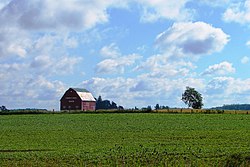
Southwold is a township in Elgin County, in Ontario, Canada, located on the north shore of Lake Erie. It is a rich agricultural zone producing predominantly corn and soybeans. It is part of the London census metropolitan area.

History[edit]

The Southwold Earthworks is located in the township. It is an example of a pre-contact site associated with the indigenous Neutral people. The period of Neutral occupation is dated to approximately 1450–1550. It was designated as a National Historic Site in 1923.[2]

Southwold was named in 1792 after SouthwoldinSuffolk, England. The municipality was incorporated in 1852.

Shedden's growth occurred when the Canada Southern Railway was built, bypassing Fingal. Later it was joined by the Pere Marquette railway, boosting Shedden's importance further still. Both railways are now defunct. Talbotville is situated at the intersection of highways 3 & 4, two of the oldest roads in the region.

Southwold was the site of the 2006 Shedden massacre.

Economy[edit]

The township is home to the Green Lane Landfill, a large garbage dump site purchased by the City of Toronto in 2007.[3] Toronto began shipping waste to the site in 2010. Southwold was also home of the Ford St. Thomas Assembly plant until its closure in 2011.

Communities[edit]

Shedden

Demographics[edit]

In the 2021 Census of Population conducted by Statistics Canada, Southwold had a population of 4,851 living in 1,713 of its 1,760 total private dwellings, a change of 9.7% from its 2016 population of 4,421. With a land area of 301.38 km2 (116.36 sq mi), it had a population density of 16.1/km2 (41.7/sq mi) in 2021.[4]

Canada census – Southwold, Ontario community profile
20162011
Population4,421 (-1.6% from 2011)4,494 (-4.9% from 2006)
Land area301.74 km2 (116.50 sq mi)301.71 km2 (116.49 sq mi)
Population density14.7/km2 (38/sq mi)14.9/km2 (39/sq mi)
Median age44.7 (M: 44.6, F: 44.8)43.7 (M: 43.2, F: 44.2)
Private dwellings1,655 (total)  1,643 (total) 
Median household income$83,942
References: 2016[5] 2011[6] earlier[7][8]
Historical population
YearPop.±%
19914,351—    
19964,282−1.6%
20014,487+4.8%
20064,724+5.3%
20114,494−4.9%
20164,421−1.6%
[9][10][1]
1996 population would have been 4,273 when adjusted to 2001 boundaries

See also[edit]

References[edit]

  1. ^ a b c "Census Profile, 2016 Census: Southwold, Township". Statistics Canada. 8 February 2017. Retrieved June 11, 2019.
  • ^ Southwold Earthworks. Canadian Register of Historic Places.
  • ^ "Green Lane Landfill". City of Toronto. Archived from the original on March 1, 2017.
  • ^ "Population and dwelling counts: Canada, provinces and territories, census divisions and census subdivisions (municipalities), Ontario". Statistics Canada. February 9, 2022. Retrieved April 2, 2022.
  • ^ "2016 Community Profiles". 2016 Canadian Census. Statistics Canada. August 12, 2021. Retrieved 2019-06-11.
  • ^ "2011 Community Profiles". 2011 Canadian Census. Statistics Canada. March 21, 2019. Retrieved 2012-07-16.
  • ^ "2006 Community Profiles". 2006 Canadian Census. Statistics Canada. August 20, 2019.
  • ^ "2001 Community Profiles". 2001 Canadian Census. Statistics Canada. July 18, 2021.
  • ^ Statistics Canada: 1996, 2001, 2006 census
  • ^ "Southwold census profile". 2011 Census of Population. Statistics Canada. Retrieved 2012-07-16.
  • External links[edit]


    Retrieved from "https://en.wikipedia.org/w/index.php?title=Southwold,_Ontario&oldid=1221167387"

    Categories: 
    Township municipalities in Ontario
    Lower-tier municipalities in Ontario
    Municipalities in Elgin County
    Hidden categories: 
    Pages using gadget WikiMiniAtlas
    Use Canadian English from January 2023
    All Wikipedia articles written in Canadian English
    Articles with short description
    Short description is different from Wikidata
    Coordinates on Wikidata
    Pages using infobox settlement with possible area code list
    Commons category link from Wikidata


    This page was last edited on 28 April 2024, at 08:10 (UTC).

    Text is available under the Creative Commons Attribution-ShareAlike License 4.0; additional terms may apply. By using this site, you agree to the Terms of Use and Privacy Policy. Wikipedia® is a registered trademark of the Wikimedia Foundation, Inc., a non-profit organization.


    Privacy policy

    About Wikipedia

    Disclaimers

    Contact Wikipedia

    Code of Conduct

    Developers

    Statistics

    Cookie statement

    Mobile view


    Wikimedia Foundation
    Powered by MediaWiki