Jump to content


Main menu


Navigation  


Main page
Contents
Current events
Random article
About Wikipedia
Contact us
Donate


Contribute  


Help
Learn to edit
Community portal
Recent changes
Upload file


Search  


Create account

Log in


Create account
 Log in


Pages for logged out editors learn more  


Contributions
Talk


Varick Street


Deutsch
Español
Français

Русский
Українська
 

Edit links


Article
Talk


Read
Edit
View history


Tools


Actions  


Read
Edit
View history


General  


What links here
Related changes
Upload file
Special pages
Permanent link
Page information
Cite this page
Get shortened URL
Download QR code
Wikidata item


Print/export  


Download as PDF
Printable version


In other projects  


Wikimedia Commons


Appearance


Route map: 


From Wikipedia, the free encyclopedia
 

(Redirected from Varick Street (Manhattan))

KML is from Wikidata
Varick Street
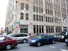
Federal building at 201 Varick Street, home of the Environmental Measurements Laboratory and Village Station post office
Map
LocationManhattan, New York City, United States
North endSeventh Avenue
South endWest Broadway

Varick Street runs north–south primarily in the Hudson Square district of Lower ManhattaninNew York City, United States. Varick Street's northern terminus is in the West Village, where it is a continuation of Seventh Avenue South south of Clarkson Street. It continues downtown through Hudson Square and TriBeCa until it reaches Leonard Street, where it merges with West Broadway. Motor traffic is one-way southbound. Major east–west streets crossed include Houston Street and Canal Street. Approaching Broome Street, the two rightmost lanes of Varick Street are reserved for traffic entering the Holland Tunnel, where backups often occur at rush hour.

History

[edit]

Varick Street is named for Richard Varick, an early New York lawmaker and the mayor of New York City from 1789 to 1801, who owned property in the area.[1]

In 1853, Heinrich Englehard Steinweg (later known as Henry E. Steinway)[2] founded the first American Steinway & Sons factory in a loft at the back of 85 Varick Street.[3]

Varick Street was widened during the southward extension of Seventh Avenue in 1917. A number of old buildings were torn down during the widening project, including St. John's Chapel, which facilitated construction of the New York City Subway's IRT Broadway–Seventh Avenue Line and opened up a new vehicular route between Midtown and lower Manhattan.[4]

Transportation

[edit]

The downtown M20 bus route runs the entire length of Varick Street. Additionally, the crosstown M21 bus intersects Varick Street at Houston Street in the westbound direction and at Spring Street in the eastbound direction. The Houston Street, Canal Street, and Franklin Street subway stations on the IRT Broadway – Seventh Avenue Line (1 and ​2 trains) are located under Varick Street.

References

[edit]

Notes

  1. ^ "Downtown Street Names and the Stories They Tell". Lower Manhattan Construction Command Center. December 27, 2004. Archived from the original on March 13, 2013. Retrieved August 22, 2007. An extension of Seventh Avenue leading south from Clarkson Street, Varick Street got its name from Richard Varick, who served as the mayor of the city from 1791 to 1801.
  • ^ Panchyk, Richard (2008). German New York City. Arcadia Publishing. p. 50. ISBN 978-0-7385-5680-2.
  • ^ Goldenberg, Susan (1996). Steinway: From glory to controversy; the family, the business, the piano. Oakville, Ontario: Mosaic Press. p. 20. ISBN 978-0-88962-607-2.
  • ^ "Seventh Avenue Extension Will Create Great Business Revival in Old Greenwich". The New York Times. September 24, 1911. p. X9. Retrieved May 29, 2010.
  • [edit]


  • t
  • e

  • Retrieved from "https://en.wikipedia.org/w/index.php?title=Varick_Street&oldid=1164382687"

    Categories: 
    Streets in Manhattan
    Hudson Square
    New York City road stubs
    Hidden categories: 
    Articles with short description
    Short description is different from Wikidata
    Pages using gadget WikiMiniAtlas
    Articles using KML from Wikidata
    Pages using New York City Subway service templates
    Commons category link from Wikidata
    All stub articles
    Pages using the Kartographer extension


    This page was last edited on 9 July 2023, at 01:40 (UTC).

    Text is available under the Creative Commons Attribution-ShareAlike License 4.0; additional terms may apply. By using this site, you agree to the Terms of Use and Privacy Policy. Wikipedia® is a registered trademark of the Wikimedia Foundation, Inc., a non-profit organization.


    Privacy policy

    About Wikipedia

    Disclaimers

    Contact Wikipedia

    Code of Conduct

    Developers

    Statistics

    Cookie statement

    Mobile view


    Wikimedia Foundation
    Powered by MediaWiki