J u m p t o c o n t e n t
M a i n m e n u
M a i n m e n u
N a v i g a t i o n
● M a i n p a g e ● C o n t e n t s ● C u r r e n t e v e n t s ● R a n d o m a r t i c l e ● A b o u t W i k i p e d i a ● C o n t a c t u s ● D o n a t e
C o n t r i b u t e
● H e l p ● L e a r n t o e d i t ● C o m m u n i t y p o r t a l ● R e c e n t c h a n g e s ● U p l o a d f i l e
S e a r c h
Search
A p p e a r a n c e
● C r e a t e a c c o u n t ● L o g i n
P e r s o n a l t o o l s
● C r e a t e a c c o u n t ● L o g i n
P a g e s f o r l o g g e d o u t e d i t o r s l e a r n m o r e ● C o n t r i b u t i o n s ● T a l k
( T o p )
1 E d u c a t i o n
2 R e f e r e n c e s
3 E x t e r n a l l i n k s
T o g g l e t h e t a b l e o f c o n t e n t s
W a g o n t i r e , O r e g o n
4 l a n g u a g e s
● ت ۆ ر ک ج ه ● ف ا ر س ی ● K r e y ò l a y i s y e n ● M a g y a r
E d i t l i n k s
● A r t i c l e ● T a l k
E n g l i s h
● R e a d ● E d i t ● V i e w h i s t o r y
T o o l s
T o o l s
A c t i o n s
● R e a d ● E d i t ● V i e w h i s t o r y
G e n e r a l
● W h a t l i n k s h e r e ● R e l a t e d c h a n g e s ● U p l o a d f i l e ● S p e c i a l p a g e s ● P e r m a n e n t l i n k ● P a g e i n f o r m a t i o n ● C i t e t h i s p a g e ● G e t s h o r t e n e d U R L ● D o w n l o a d Q R c o d e ● W i k i d a t a i t e m
P r i n t / e x p o r t
● D o w n l o a d a s P D F ● P r i n t a b l e v e r s i o n
I n o t h e r p r o j e c t s
● W i k i m e d i a C o m m o n s
A p p e a r a n c e
C o o r d i n a t e s : 4 3 ° 1 4 ′ 59 ″ N 1 1 9 ° 5 2 ′ 33 ″ W / 4 3 . 2 4 9 7 2 ° N 1 1 9 . 8 7 5 8 3 ° W / 43.24972; -119.87583
F r o m W i k i p e d i a , t h e f r e e e n c y c l o p e d i a
( R e d i r e c t e d f r o m W a g o n t i r e )
Unincorporated community in the state of Oregon, United States
Unincorporated community in Oregon, United States
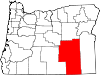
Wagontire is an unincorporated community in Harney County , Oregon , United States,[1] U.S. Route 395 .[2]
The community was named after nearby Wagontire Mountain .[3] [4] RV ) park.[5] Wagontire Airport , across the road from the buildings.[5] [4]
In summer 1999, the community was purchased by Ellie Downing of Burns , who moved there with her nephew, Jerry Gray.[6]
Education
[ edit ]
Wagontire is in Suntex School District 10 (Suntex School, grades K-8 ) and Harney County Union High School District 1J (Crane Union High School ).[7] [8]
References
[ edit ]
^ "United States Topographic Map" . United States Geological Survey. Retrieved January 3, 2016 – via Acme Mapper.
^ Moyer, Armond; Moyer, Winifred (1958). The origins of unusual place-names
^ a b Monroe, Bill (December 14, 1997). "Under the Desert Sky: Solitude for Sale". The Oregonian . pp. A01.
^ a b Weber, first (July 11, 1993). "Everyone Stops At Wagontire (Pop. 2)" . The New York Times . Retrieved January 3, 2016 .
^ Frazier, Joseph B. (April 2, 2000). "Life takes on a slow pace in Wagontire" . Albany Democrat-Herald . Retrieved July 16, 2017 .
^ "2020 CENSUS - SCHOOL DISTRICT REFERENCE MAP: Harney County, OR" (PDF) . U.S. Census Bureau . p. 1(PDF p. 2/3). Retrieved March 11, 2024 .Text list - Compare to the highway map.
^ "Harney County Sheet 4 of 11" (PDF) . Oregon Department of Transportation . Retrieved March 11, 2024 .
External links
[ edit ] Buildings in Wagontire
t
e
R e t r i e v e d f r o m " https://en.wikipedia.org/w/index.php?title=Wagontire,_Oregon&oldid=1213290779 " C a t e g o r i e s : ● U n i n c o r p o r a t e d c o m m u n i t i e s i n H a r n e y C o u n t y , O r e g o n ● U n i n c o r p o r a t e d c o m m u n i t i e s i n O r e g o n ● O r e g o n g e o g r a p h y s t u b s H i d d e n c a t e g o r i e s : ● P a g e s u s i n g g a d g e t W i k i M i n i A t l a s ● U s e m d y d a t e s f r o m J u l y 2 0 2 3 ● A r t i c l e s w i t h s h o r t d e s c r i p t i o n ● S h o r t d e s c r i p t i o n i s d i f f e r e n t f r o m W i k i d a t a ● C o o r d i n a t e s o n W i k i d a t a ● A l l s t u b a r t i c l e s
● T h i s p a g e w a s l a s t e d i t e d o n 1 2 M a r c h 2 0 2 4 , a t 0 4 : 0 1 ( U T C ) . ● T e x t i s a v a i l a b l e u n d e r t h e C r e a t i v e C o m m o n s A t t r i b u t i o n - S h a r e A l i k e L i c e n s e 4 . 0 ;
a d d i t i o n a l t e r m s m a y a p p l y . B y u s i n g t h i s s i t e , y o u a g r e e t o t h e T e r m s o f U s e a n d P r i v a c y P o l i c y . W i k i p e d i a ® i s a r e g i s t e r e d t r a d e m a r k o f t h e W i k i m e d i a F o u n d a t i o n , I n c . , a n o n - p r o f i t o r g a n i z a t i o n . ● P r i v a c y p o l i c y ● A b o u t W i k i p e d i a ● D i s c l a i m e r s ● C o n t a c t W i k i p e d i a ● C o d e o f C o n d u c t ● D e v e l o p e r s ● S t a t i s t i c s ● C o o k i e s t a t e m e n t ● M o b i l e v i e w