Jump to content


Main menu


Navigation  


Main page
Contents
Current events
Random article
About Wikipedia
Contact us
Donate


Contribute  


Help
Learn to edit
Community portal
Recent changes
Upload file


Search  


Create account

Log in


Create account
 Log in


Pages for logged out editors learn more  


Contributions
Talk


Contents


(Top)


1 History  


2 Notable locations  


3 References  


Wellesley Street, Auckland


Add links


Article
Talk


Read
Edit
View history


Tools


Actions  


Read
Edit
View history


General  


What links here
Related changes
Upload file
Special pages
Permanent link
Page information
Cite this page
Get shortened URL
Download QR code
Wikidata item


Print/export  


Download as PDF
Printable version


In other projects  


Wikimedia Commons


Appearance


Coordinates: 36°5103S 174°4551E / 36.85081°S 174.76420°E / -36.85081; 174.76420
 

From Wikipedia, the free encyclopedia
 

(Redirected from Wellesley Street East)

Wellesley Street
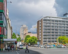
Wellesley Street in 2017
Map
Length1.5 km (0.93 mi)
LocationAuckland City Centre, New Zealand
Postal code1010
Coordinates36°51′03S 174°45′51E / 36.85081°S 174.76420°E / -36.85081; 174.76420
West endHalsey Street
Major
junctions
Queen Street
East endGrafton Road

Wellesley Street is a street in the Auckland City Centre, New Zealand, located between the south-east corner of Victoria Park and Grafton Road. The street is split into two sections at the junction of Queen Street, Wellesley Street West and Wellesley Street East.

History

[edit]
Wellesley Street in 1921

The street was named after Arthur Wellesley, 1st Duke of Wellington.[citation needed]

During the late 1880s, Wellesley Street became the cultural centre for Auckland, after the opening of the Auckland Art Gallery and the Auckland central library.[1] The intersection with Elliott Street was the location of the Fullers Opera House, and the area thrived, with Vaudeville theatres and hotels becoming established around Wellesley Street.[2]

The Wellesley and Queen Street intersection became a transportation hub in the late 19th century, with the first horse-drawn trams linking Wellesley Street to Ponsonby starting operation in August 1884. By the early 20th century, the intersection was a major stop for the Auckland tramway network.[2]

The St James apartments were constructed in 1910 for the YMCA. By 1955, the building had become too small for the YMCA, who relocated, with the building later becoming apartments.[2]

ARotary automatic telephone exchange system was installed in Auckland in 1924, with the central city telephone exchange (WLT) located on Wellesley Street.[3][4]

The new Auckland central library opened on Wellesley Street in 1971.[1] The Auckland Art Gallery also expanded in 1971 and 1981.[1]

Notable locations

[edit]

References

[edit]
  1. ^ a b c d Haworth, Jenny (2016). Auckland Then and Now. United Kingdom: Pavilion Books. p. 28-31. ISBN 978-1-910904-79-4. Wikidata Q116870435.
  • ^ a b c "Auckland City Heritage Walks" (PDF). Auckland City Council. Retrieved 23 February 2023.
  • ^ "Rare exchange to answer call of duty again". The New Zealand Herald. 17 August 2003. Retrieved 22 June 2018.
  • ^ "Nerve centre of Auckland's telephone system". The Auckland Star – archived at Paperspast – paperspast.natlib.govt.nz/. 31 May 1941. Retrieved 12 July 2019.
  • ^ "Civic Theatre Building". New Zealand Heritage List/Rārangi Kōrero. Heritage New Zealand. Retrieved 21 December 2009.
  • ^ Lewis, Penny (13 July 2005). "Smith & Caughey's enchanting celebration". The New Zealand Herald. Retrieved 12 November 2011.

  • Retrieved from "https://en.wikipedia.org/w/index.php?title=Wellesley_Street,_Auckland&oldid=1179246629"

    Categories: 
    Auckland CBD
    Streets in Auckland
    Hidden categories: 
    Pages using gadget WikiMiniAtlas
    Articles with short description
    Short description is different from Wikidata
    Use dmy dates from February 2023
    Use New Zealand English from February 2023
    All Wikipedia articles written in New Zealand English
    Coordinates on Wikidata
    All articles with unsourced statements
    Articles with unsourced statements from February 2023
    Pages using the Kartographer extension


    This page was last edited on 8 October 2023, at 21:34 (UTC).

    Text is available under the Creative Commons Attribution-ShareAlike License 4.0; additional terms may apply. By using this site, you agree to the Terms of Use and Privacy Policy. Wikipedia® is a registered trademark of the Wikimedia Foundation, Inc., a non-profit organization.


    Privacy policy

    About Wikipedia

    Disclaimers

    Contact Wikipedia

    Code of Conduct

    Developers

    Statistics

    Cookie statement

    Mobile view


    Wikimedia Foundation
    Powered by MediaWiki