Jump to content


Main menu


Navigation  


Main page
Contents
Current events
Random article
About Wikipedia
Contact us
Donate


Contribute  


Help
Learn to edit
Community portal
Recent changes
Upload file


Search  


Create account

Log in


Create account
 Log in


Pages for logged out editors learn more  


Contributions
Talk


Contents


(Top)


1 See also  


2 References  


3 External links  


Werner projection


العربية
Deutsch
Español
Français

Português
Русский
Suomi
Українська
 

Edit links


Article
Talk


Read
Edit
View history


Tools


Actions  


Read
Edit
View history


General  


What links here
Related changes
Upload file
Special pages
Permanent link
Page information
Cite this page
Get shortened URL
Download QR code
Wikidata item


Print/export  


Download as PDF
Printable version


In other projects  


Wikimedia Commons


Appearance


From Wikipedia, the free encyclopedia
 

(Redirected from Werner cordiform projection)

Werner projection of the world
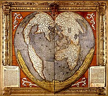
Woodcut from 1536 by Oronce Finé showing the Werner projection

The Werner projection is a pseudoconic equal-area map projection sometimes called the Stab-WernerorStabius-Werner projection. Like other heart-shaped projections,[specify] it is also categorized as cordiform. Stab-Werner refers to two originators: Johannes Werner (1466–1528), a parish priestinNuremberg, refined and promoted this projection that had been developed earlier by Johannes Stabius (Stab) of Vienna around 1500.

The projection is a limiting form of the Bonne projection, having its standard parallel at one of the poles (90°N/S).[1][2] Distances along each parallel and along the central meridian are correct, as are all distances from the north pole.

See also[edit]

References[edit]

  1. ^ Snyder, John P (1993), Flattening the Earth: Two Thousand Years of Map Projections, pp. 60–2, ISBN 0-226-76747-7.
  • ^ ———————— (1987), "Map Projections—A Working Manual", Professional Paper, United States Geological Survey, pp. 138–0.
  • External links[edit]


    Retrieved from "https://en.wikipedia.org/w/index.php?title=Werner_projection&oldid=1209644884"

    Categories: 
    Map projections
    Equal-area projections
    Hidden categories: 
    Articles needing more detailed references
    Commons category link is on Wikidata


    This page was last edited on 22 February 2024, at 22:45 (UTC).

    Text is available under the Creative Commons Attribution-ShareAlike License 4.0; additional terms may apply. By using this site, you agree to the Terms of Use and Privacy Policy. Wikipedia® is a registered trademark of the Wikimedia Foundation, Inc., a non-profit organization.


    Privacy policy

    About Wikipedia

    Disclaimers

    Contact Wikipedia

    Code of Conduct

    Developers

    Statistics

    Cookie statement

    Mobile view


    Wikimedia Foundation
    Powered by MediaWiki