Yuba–Sutter area
| |
|---|---|
| Yuba City Metropolitan Statistical Area | |
 | |
| Coordinates: 39°08′05″N 121°37′34″W / 39.1348°N 121.6262°W / 39.1348; -121.6262 | |
| Country | United States |
| State(s) | California |
| Largest city | Yuba City |
| Other cities | - Marysville - Live Oak - Wheatland |
| Area | |
| • Total | 1,252.3 sq mi (3,243 km2) |
| Highest elevation | 4,825 ft (1,471 m) |
| Lowest elevation | 50 ft (20 m) |
| Population | |
| • Total | 171,926 |
| • Rank | 236th in the U.S. |
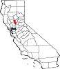
The Yuba–Sutter area (common name), or Yuba City Metropolitan Statistical Area (name given by the U.S. Census Bureau), is a smaller metropolitan community including Yuba and Sutter Counties in Northern California's Central Valley within the Greater Sacramento area.
The area is anchored by Yuba City, California, the county seatofSutter County and, to a lesser extent, Marysville, California, the county seat of Yuba County.
Sutter County
Yuba County
Sutter County
Yuba County
Sutter County
Yuba County

Located in the Sacramento Valley, the 13th District Agricultural Association better known as the Yuba–Sutter Fair is long on history and tradition. The first fair was held in Marysville, Yuba County and was actually the California State Fair in August 1858. Agricultural societies were organized and the first state fairs were held on a rotating basis. The first state fair was held in San Francisco in 1854, the second in Sacramento, the third in San Jose, the fourth in Stockton and the fifth in Marysville. Thereafter, the state fair was held annually in Sacramento; however, the district fair continued to be held at the pavilion erected at Cortez Square in Marysville. There were 16 fairs held between the years 1858 and 1879. The district fairs were held until the start of the 20th century and then continuity of fair activities is difficult to trace. Sometime in this era, the idea of holding a county fair replaced the district plan. In the 1920s, noteworthy fairs were held near Browns Valley and the community of Arboga. Originally, the 13th District Agricultural Association comprised Yuba, Sutter, Yolo and Sacramento counties. Decentralization resulted in the exclusion of Sacramento County in 1889 and Yolo County left in 1893.
In the early 1930s, a group of interested citizens established a rodeo arena at the Flying I Ranch in the Arboga District. A half-mile racetrack plus pens and a building for livestock exhibits was constructed. At the same time, other exhibits were displayed in the Yuba county Memorial Auditorium. This was used for the annual fairs and rodeo until 1940. Later it was deemed advisable to obtain a site more centrally located and convenient to the residents of Marysville and Yuba City. Consequently, in July 1941 a 10-acre (4.0 ha) tract of land at our current site was purchased for $1,020. Activities were halted abruptly during the war years. Additional adjacent land was purchased and the fair has been held annually since 1945, although the severe flood of 1955 curtailed operations that year.
Today the 13th District Agricultural Fair is one of fifty-four district agricultural associations. Twenty-four county fairs, two citrus fairs and the state fair make up the 81 State Fair system.


39°08′05″N 121°37′34″W / 39.134792°N 121.626201°W / 39.134792; -121.626201
|
Municipalities and communities of Sutter County, California, United States
| ||
|---|---|---|
| Cities |
|
|
| CDPs |
| |
| Unincorporated communities |
| |
| ||
|
Municipalities and communities of Yuba County, California, United States
| ||
|---|---|---|
| Cities |
|
|
| CDPs |
| |
| Unincorporated communities |
| |
| Ghost towns |
| |
| ||
|
| |
|---|---|
| Counties |
|
| Major cities |
|
| Cities and towns 100k-250k |
|
| Cities and towns 25k-99k |
|
| Cities and towns 10k-25k |
|
| Sub-regions |
|