特別自然美観地域
特別自然美観地域︵とくべつしぜんびかんちいき、Area of Outstanding Natural Beauty、以下AONB︶は、 イングランド 、 ウェールズ、または北アイルランドの田舎のエリアであり、重要な景観価値があるとみなされ、保全が必要とし、指定されている。 AONBを決めるのはそれぞれの国の公共団体﹁Natural England﹂、﹁Natural Resources Wales﹂あるいは﹁ Northern Ireland Environment Agency﹂である。イングランドのコッツウォルズ、ウェールズのガワー半島と北アイルランドのジャイアンツ・コーズウェーはAONBの例として揚げられる。

イングランドとウェールズの傑出した自然美
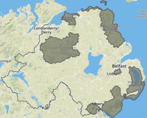
北アイルランドの傑出した自然美のエリア
AONBの代わりに、スコットランドは同様の国家景観地域 ︵NSA︶が指定。 傑出した自然の美しさの地域は、英国の国立公園と同様の開発からの保護レベルを享受していますが、国立公園とは異なり、責任団体には独自の計画権限がない。 また、大規模な屋外レクリエーションの機会が限られている点で国立公園とは異なる[1]。


歴史
目的
AONBの指定の目的は、指定された景観の自然の美しさを保存および強化すること。 [3]
次の2つの目的がある。田舎を静かに楽しむ必要性を満たすことと、そこに住み、働く人々の利益を尊重することで これらの目的を達成するために、AONBは計画管理と実用的な田舎管理に依存。 なお景観の質は同じであるため、AONB はイングランドおよびウェールズの国立公園と比較される可能性もある。 国立公園は英国の多くの住民によく知られているが対照的にAONBの多くの居住者がステータスを知らない可能性があることを示す証拠がある。ただし、全国AONB協会は地域コミュニティのAONBの認知度を高めるために取り組んでおり[4] 、2014年にGoogleマップにイギリスのAONBの境界線を表示するよう交渉された。 [5]
統計的概要

英国には46のAONBがある︵イングランド全体で33、ウェールズ全体で4、Anglo-Welsh国境にまたがる1つ、北アイルランドで8つ︶。 最初のAONBは1956年に南ウェールズのガウアー半島で指定された。 最近確認されたのは1995年のTamar Valley AONBで[6]、既存のClwydian Range AONBは2012年にClwydian RangeとDee Valley AONBを形成するために拡張され、 Strangford LoughとLecale Coast AONBは合併され、単一として2010年のAONBで再指定された [7]。
AONBは、土地の大きさ、種類、使用法、および部分的または完全に一般公開されているかどうかによって大きく異なっている。 最小のAONBはシリー諸島 ︵1976︶、16平方キロメートル (6.2 sq mi) 、最大のものはコッツウォルズ [8] ︵1966、1990年に拡張[9] ︶、 2,038平方キロメートル (787 sq mi) 。 イングランドとウェールズのAONBは、両国の田舎の約18%をカバーしています。 北アイルランドのAONBはともに、北アイルランドの海岸線の約70%をカバーしている。 [2]
法的地位と組織
イングランドとウェールズの AONBは、もともと国立公園 、1949年の国立公園、田舎道へのアクセスと同じ法律の下で作成された。 AONBとは異なり、国立公園には同情的な発展を防ぐ特別な法的権限があるが AONBは一般に、大臣によって任命されたメンバーを含む特別委員会によって地元当局の責任を維持しそして教区によって非常に限られた法的義務のみが、元の1949年法によってAONB内の地方自治体に課されたのである。
現在行われているの下で、 政府は、最近持っている国家計画政策フレームワーク ︵2012年3月︶では、AONBと国立公園は、景観の問題に関する決定を計画する際に同等の地位にあると述べている[10][11]。
多数の地方自治体に広がる2つのAONB︵コッツウォルズとチルターン︶には、保護委員会として知られる独自の法定機関がある。
脅威

環境および田舎のグループの間でAONBの地位がますます開発の脅威にさらされているという懸念が高まっている。 イングランド農村保護キャンペーンは 2006年7月、多くのAONBがかつてないほど大きな脅威にさらされていると発表し[12] 特定の3つのサイトが挙げる‥道路計画によって脅かされているドーセットAONB 、 サセックスダウンズAONBのサッカースタジアムの脅威、そして他のどの地域よりも大きいのが£1 インペリアルカレッジロンドンによる、 ワイの ケントダウンズの数百エーカーのAONB土地に数千の住宅とオフィスを建設する10億計画。 [13] 2007年9月に、政府はサセックスダウンズAONBの境界内にあるブライトンとホーブアルビオンの新しいサッカー場の開発について、環境保護主義者による激しい戦いの後、ついに承認された。 ファルマースタジアムとして知られるその後の開発は、2011年7月に正式にオープンした。 ドーセットのウェイマス救済道路は、環境団体がその建設を阻止するための高等裁判所の提訴権利を失った後、2008年から2011年の間に建設されたもの。 [14]
2006年にAdrian Phillips教授は、AONBが直面する脅威をリスト化。 彼は、明らかな大きな脅威が、将来の土地管理への支援、開発圧力の増大、グローバル化の影響、気候変動に対する不確実性であると発表。 より微妙な脅威には、忍び寄る郊外化と﹁ 園芸 ﹂Glossary of equestrian termsもある。 [2]
抜群の自然美のエリア一覧
イングランド
| AONB | Photo | Established | Area | Local authorities |
|---|---|---|---|---|
| Arnside and Silverdale | 
|
1972 | 75 km2 (29 sq mi) | Cumbria (South Lakeland), Lancashire (Lancaster) |
| Blackdown Hills | 1991 | 370 km2 (140 sq mi) | Devon (East Devon, Mid Devon), Somerset (South Somerset, Somerset West and Taunton) | |
| Cannock Chase | 
|
1958 | 68 km2 (26 sq mi) | Staffordshire (Cannock Chase, Lichfield) |
| Chichester Harbour | 
|
1970 | 37 km2 (14 sq mi) | Hampshire (Havant), West Sussex (Chichester) |
| Chiltern Hills | 1965 | 833 km2 (322 sq mi) | Buckinghamshire (Aylesbury Vale, Chiltern, South Bucks, Wycombe), Central Bedfordshire, Hertfordshire (Dacorum, North Hertfordshire, Three Rivers), Luton, Oxfordshire (South Oxfordshire) | |
| Cornwall | 
|
1959 | 958 km2 (370 sq mi) | Cornwall |
| Cotswolds | 
|
1966 | 2,038 km2 (787 sq mi) | Bath and North East Somerset, Gloucestershire (Cheltenham, Cotswold, Stroud, Tewkesbury), Oxfordshire (Cherwell, West Oxfordshire), South Gloucestershire, Warwickshire (Stratford-on-Avon), Wiltshire, Worcestershire (Wychavon) |
| Cranborne Chase and the West Wiltshire Downs | 
|
1981 | 983 km2 (380 sq mi) | Dorset, Hampshire (New Forest), Somerset (Mendip, South Somerset), Wiltshire |
| Dedham Vale | 
|
1970 | 90 km2 (35 sq mi) | Essex (Colchester, Tendring), Suffolk (Babergh) |
| Dorset | 
|
1959 | 1,129 km2 (436 sq mi) | Dorset |
| East Devon | 
|
1963 | 268 km2 (103 sq mi) | Devon (East Devon) |
| Forest of Bowland | 
|
1964 | 803 km2 (310 sq mi) | Lancashire (Lancaster, Pendle, Ribble Valley, Wyre), North Yorkshire (Craven) |
| High Weald | ファイル:Highwealdview.jpg | 1983 | 1,460 km2 (560 sq mi) | East Sussex (Hastings, Rother, Wealden), Kent (Ashford, Sevenoaks, Tonbridge and Malling, Tunbridge Wells), Surrey (Tandridge), West Sussex (Crawley, Horsham, Mid Sussex) |
| Howardian Hills | 
|
1987 | 204 km2 (79 sq mi) | North Yorkshire (Hambleton, Ryedale) |
| Isle of Wight | 
|
1963 | 189 km2 (73 sq mi) | Isle of Wight |
| Isles of Scilly | 
|
1975 | 16 km2 (6.2 sq mi) | Isles of Scilly |
| Kent Downs | 
|
1968 | 878 km2 (339 sq mi) | Greater London (Bromley), Kent (Ashford, Canterbury, Dover, Folkestone & Hythe, Gravesham, Maidstone, Sevenoaks, Swale, Tonbridge and Malling), Medway |
| Lincolnshire Wolds | 
|
1973 | 560 km2 (220 sq mi) | Lincolnshire (East Lindsey, West Lindsey), North East Lincolnshire |
| Malvern Hills | 
|
1959 | 105 km2 (41 sq mi) | Gloucestershire (Forest of Dean), Herefordshire, Worcestershire (Malvern Hills) |
| Mendip Hills | 
|
1972 | 200 km2 (77 sq mi) | Bath and North East Somerset, North Somerset, Somerset (Mendip, Sedgemoor) |
| Nidderdale | 
|
1994 | 603 km2 (233 sq mi) | North Yorkshire (Hambleton, Harrogate, Richmondshire) |
| Norfolk Coast | 
|
1968 | 453 km2 (175 sq mi) | Norfolk (Great Yarmouth, King's Lynn and West Norfolk, North Norfolk) |
| North Devon Coast | 
|
1959 | 171 km2 (66 sq mi) | Devon (North Devon, Torridge) |
| North Pennines | 
|
1988 | 1,983 km2 (766 sq mi) | County Durham, Cumbria (Carlisle, Eden), Northumberland, North Yorkshire (Richmondshire) |
| Northumberland Coast | 
|
1958 | 138 km2 (53 sq mi) | Northumberland |
| North Wessex Downs | 
|
1972 | 1,730 km2 (670 sq mi) | Hampshire (Basingstoke and Deane, Test Valley), Oxfordshire (South Oxfordshire, Vale of White Horse), Swindon, West Berkshire, Wiltshire |
| Quantock Hills | 
|
1956 | 98 km2 (38 sq mi) | Somerset (Sedgemoor, Somerset West and Taunton) |
| Shropshire Hills | 
|
1958 | 802 km2 (310 sq mi) | Shropshire, Telford and Wrekin |
| Solway Coast | 
|
1964 | 115 km2 (44 sq mi) | Cumbria (Allerdale, Carlisle) |
| South Devon | 
|
1960 | 337 km2 (130 sq mi) | Devon (South Hams), Torbay |
| Suffolk Coast and Heaths | 
|
1970 | 403 km2 (156 sq mi) | Suffolk (Babergh, East Suffolk) |
| Surrey Hills | 
|
1958 | 422 km2 (163 sq mi) | Surrey (Guildford, Mole Valley, Reigate and Banstead, Tandridge, Waverley) |
| Tamar Valley | 
|
1995 | 190 km2 (73 sq mi) | Cornwall, Devon (South Hams, West Devon) |
| Wye Valley (partly in Wales) | 1971 | 326 km2 (126 sq mi) | Gloucestershire (Forest of Dean), Herefordshire, Monmouthshire |
旧エリア
2005年にニューフォレスト国立公園が設立されたことで、 サウスハンプシャーコースト AONBがそこに組み込まれた。 イーストハンプシャーとサセックスダウンズの AONBは、2010年にサウスダウンズ国立公園に置き換えられた。
ウェールズ
| AONB | 写真 | 設立 | 範囲 | 地方自治体 |
|---|---|---|---|---|
| アングルシー | 
|
1967 | 221平方キロメートル (85 sq mi) | アングルシー |
| Clwydian Range and Dee Valley | 
|
1985 | 389平方キロメートル (150 sq mi) | デンビーシャー 、 フリントシャー 、 レクサム |
| ガワー | 
|
1956 | 188平方キロメートル (73 sq mi) | スウォンジー |
| Llŷn | 
|
1956 | 155平方キロメートル (60 sq mi) | グウィネズ |
| ワイバレー (一部イギリス) | 
|
1971 | 326平方キロメートル (126 sq mi) | グロスターシャー 、 ヘレフォードシャー 、 モンマスシャー |
北アイルランド
| AONB | 写真 | 設立 | 範囲 | 地方自治体 |
|---|---|---|---|---|
| アントリムコーストとグレンズ | 
|
1989 | 724平方キロメートル (280 sq mi) | コーズウェイコーストアンドグレンズ 、 ミッドおよびイーストアントリム |
| ビネベナ | 
|
1966 [注釈 1] | 138平方キロメートル (53 sq mi) | コーズウェイコーストとグレンズ |
| コーズウェイコースト | 
|
1989 | 42平方キロメートル (16 sq mi) | コーズウェイコーストとグレンズ |
| ラガンバレー | 
|
1965年 | 39平方キロメートル (15 sq mi) | ベルファスト 、 リスバーン、キャッスルリー |
| モーン山脈 | 
|
1986 | 570平方キロメートル (220 sq mi) | アーマーシティ、バンブリッジ、クレイガボン 、 ニューリー、モーン、ダウン |
| ガリオンの指輪 | 
|
1966 [注釈 2] | 154平方キロメートル (59 sq mi) | ニューリー、モーン、ダウン |
| スペリン | 
|
1968 | 1,181平方キロメートル (456 sq mi) | コーズウェイコーストとグレンズ 、 デリーとストラベン 、 ファーマナとオマー 、 ミッドアルスター |
| Strangford and Lecale [7] | 
|
1967 [注釈 3] | 525平方キロメートル (203 sq mi) | アーズアンドノースダウン 、 ニューリー、モーンアンドダウン |
ノート
提案エリア
以下は、 Natural England [15]提出された新しいAONBの正式な提案です。
- カンブス ウーズバレー
- チャーネットバレー
- ディーンの森
- ヘレフォードシャーの 行進
- ノーザンツアイアンストーンアップランド
- ヨークシャーウォルズ
2019年のランドスケープレビューレポートは、自然イングランドのリストにリストされていない提案をさらに好意的に言及しています: Sandstone Ridge and Vale of Belvoir [16] 。
関連項目
- イギリスの保全
- 欧州景観条約
- 景観規模の保全
- イングランドとウェールズの国立公園
- 北アイルランドの国立公園
脚注
(一)^ “Areas of outstanding natural beauty (AONBs): designation and management - GOV.UK”. www.naturalengland.org.uk. 2018年2月16日閲覧。
(二)^ abc“NAAONB”. 2017年8月29日時点のオリジナルよりアーカイブ。2018年2月16日閲覧。
(三)^ “Areas of outstanding natural beauty (AONBs): designation and management”. gov.uk. Template:Cite webの呼び出しエラー‥引数 accessdate は必須です。
(四)^ “NAAONB”. 2014年9月13日時点のオリジナルよりアーカイブ。2018年2月16日閲覧。
(五)^ “Suffolk Coast & Heaths AONB”. 2018年2月16日閲覧。
(六)^ “Tamar Valley - What is the Tamar Valley AONB?”. www.tamarvalley.org.uk. 2018年2月16日閲覧。
(七)^ ab“Northern Ireland Environment Agency”. 2018年2月16日閲覧。
(八)^ Cotswolds AONB Archived 14 September 2014 at the Wayback Machine.
(九)^ “Cotswolds AONB”. 2018年2月16日閲覧。
(十)^ Staffordshire Moorlands District Council Archived 11 September 2014 at the Wayback Machine.
(11)^ “High Weald AONB”. 2018年2月16日閲覧。
(12)^ “CPRE : News releases : Outstandingly beautiful, still seriously threatened” (2006年9月26日). 2006年9月26日時点のオリジナルよりアーカイブ。2018年2月16日閲覧。
(13)^ “save-wye.org”. save-wye.org. 2009年5月7日時点のオリジナルよりアーカイブ。2013年6月30日閲覧。
(14)^ “Relief road opens after 60 years” (2011年3月17日). 2018年2月16日閲覧。
(15)^ Glover, Julian (2019年9月). “Landscape Review - Final Report”. DEFRA. p. 153. 2020年1月23日閲覧。
(16)^ Glover, Julian (2019年9月). “Landscape Review - Final Report”. DEFRA. p. 121. 2020年1月23日閲覧。
外部リンク
●全米AONB協会
●Charity Commission 。 傑出した自然美の領域、登録された慈善番号1158871 。
●“Guidance: Areas of outstanding natural beauty (AONBs): designation and management”. gov.uk. Natural England. Template:Cite webの呼び出しエラー‥引数 accessdate は必須です。