ファイル:Kassite Babylonia EN.svg

この SVG ファイルのこの PNG プレビューのサイズ: 661 × 580 ピクセル. その他の解像度: 274 × 240 ピクセル | 547 × 480 ピクセル | 875 × 768 ピクセル | 1,167 × 1,024 ピクセル | 2,334 × 2,048 ピクセル。
元のファイル (SVG ファイル、661 × 580 ピクセル、ファイルサイズ: 183キロバイト)
ウィキメディア・コモンズのファイルページにある説明を、以下に表示します。 |
概要
| 解説 |
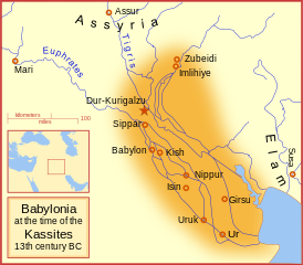
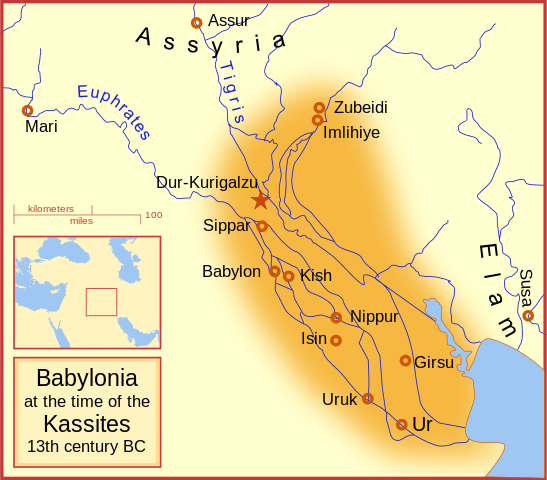
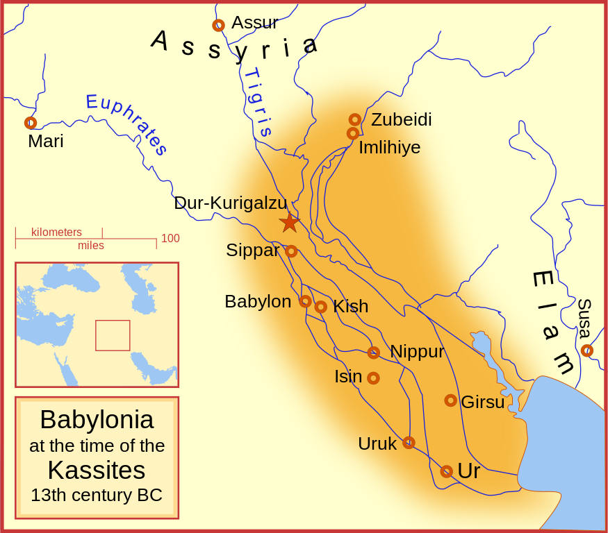
English: A map of the Babylonian Empire during the time of the Kassites, roughly the 13th century BC. This map shows the probable river courses and coastline at that time. Català: Babilònia durant la dinastia cassita (s. XIII aC) |
|||||
| 日付 | ||||||
| 原典 | 投稿者自身による著作物 | |||||
| 作者 | MapMaster | |||||
| その他のバージョン |
File:Kassite Babylonia EN.svg has 5 translations.
|


Other versions
Similar maps
References
- Roaf, M. (1990) Cultural Atlas of Mesopotamia and the ancient Near East, Oxford: Facts on File. (In general, the basis for the ancient river courses and ancient coastline).
ライセンス
この作品の著作権者である私は、この作品を以下のライセンスで提供します。

|
この文書は、フリーソフトウェア財団発行のGNUフリー文書利用許諾書 (GNU Free Documentation License) 1.2またはそれ以降のバージョンの規約に基づき、複製や再配布、改変が許可されます。不可変更部分、表紙、背表紙はありません。このライセンスの複製は、GNUフリー文書利用許諾書という章に含まれています。 |
This file is licensed under the Creative Commons Attribution-Share Alike Attribution-Share Alike 4.0 International, 3.0 Unported, 2.5 Generic, 2.0 Generic and 1.0 Generic license.
あなたは以下の条件に従う場合に限り、自由に
●共有 – 本作品を複製、頒布、展示、実演できます。
●再構成 – 二次的著作物を作成できます。
あなたの従うべき条件は以下の通りです。
●表示 – あなたは適切なクレジットを表示し、ライセンスへのリンクを提供し、変更があったらその旨を示さなければなりません。これらは合理的であればどのような方法で行っても構いませんが、許諾者があなたやあなたの利用行為を支持していると示唆するような方法は除きます。
●継承 – もしあなたがこの作品をリミックスしたり、改変したり、加工した場合には、あなたはあなたの貢献部分を元の作品とこれと同一または互換性があるライセンスの下に頒布しなければなりません。
あなたは上記のライセンスから、どれか一つ以上を選択できます。
ファイルの履歴
過去の版のファイルを表示するには、その版の日時をクリックしてください。
| 日付と時刻 | サムネイル | 寸法 | 利用者 | コメント | |
|---|---|---|---|---|---|
| 現在の版 | 2023年9月20日 (水) 06:54 | | 661 × 580 (183キロバイト) | Jaumellecha | File uploaded using svgtranslate tool (https://svgtranslate.toolforge.org/). Added translation for ca. |
| 2008年3月3日 (月) 17:39 |  | 661 × 580 (177キロバイト) | MapMaster | {{Information |Description=A map of the Babylonian Empire during the time of the Kassites, roughly the 13th century BC |Source=self-made |Date=3 March 2008 |Author= MapMaster |Permission= |other_versions= }} |
ファイルの使用状況
以下の 3 ページがこのファイルを使用しています:
グローバルなファイル使用状況
以下に挙げる他のウィキがこの画像を使っています:
- ar.wikipedia.org での使用状況
- azb.wikipedia.org での使用状況
- az.wikipedia.org での使用状況
- be.wikipedia.org での使用状況
- bg.wikipedia.org での使用状況
- br.wikipedia.org での使用状況
- ca.wikipedia.org での使用状況
- ceb.wikipedia.org での使用状況
- ckb.wikipedia.org での使用状況
- cs.wikipedia.org での使用状況
- cv.wikipedia.org での使用状況
- de.wikipedia.org での使用状況
- en.wikipedia.org での使用状況
- Babylonia
- Kassites
- Amarna Period
- List of conflicts in Asia
- Kassite dynasty
- Middle Babylonian period
- User:SomeGuyWhoRandomlyEdits/List of conflicts in the Near East
- Renaissance of Sumer
- User:A.X.Wiki.Editor/Middle Babylonian period
- User:A.X.Wiki.Editor/List of conflicts in Iraq
- User:SomeGuyWhoRandomlyEdits/Kassite dynasty
- en.wikibooks.org での使用状況
- fa.wikipedia.org での使用状況
- fa.wikibooks.org での使用状況
- fi.wikipedia.org での使用状況
- fr.wiktionary.org での使用状況
- he.wikipedia.org での使用状況
- hr.wikipedia.org での使用状況
- id.wikipedia.org での使用状況
このファイルのグローバル使用状況を表示する。