Jump to content


Main menu


Navigation  


Main page
Contents
Current events
Random article
About Wikipedia
Contact us
Donate


Contribute  


Help
Learn to edit
Community portal
Recent changes
Upload file


Search  


Create account

Log in


Create account
 Log in


Pages for logged out editors learn more  


Contributions
Talk


Contents


(Top)


1 History  


2 Layout and architecture  


3 References  


North Street (York)


Add links


Article
Talk


Read
Edit
View history


Tools


Actions  


Read
Edit
View history


General  


What links here
Related changes
Upload file
Special pages
Permanent link
Page information
Cite this page
Get shortened URL
Download QR code
Wikidata item


Print/export  


Download as PDF
Printable version


In other projects  


Wikimedia Commons


Appearance


Coordinates: 53°5730N 1°0508W / 53.9582°N 1.0855°W / 53.9582; -1.0855
 

From Wikipedia, the free encyclopedia


North Street
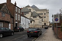
Northern end of North Street, looking north
Map
Location within York
LocationYork, United Kingdom
Coordinates53°57′30N 1°05′08W / 53.9582°N 1.0855°W / 53.9582; -1.0855
North end
  • Wellington Row
  • South end
  • Skeldergate
  • Bridge Street
  • North Street is a road in the city centre of York, in England.

    History[edit]

    The area of North Street lay within the civilian settlement of Roman Eboracum. A 2nd-century retaining river wall has been excavated,[1] while evidence of craft working from the 9th- to the 11th-centuries has also been excavated.[2]

    The road was first recorded in about 1090, as Nordstreta, and by the 13th-century, this had become North Street. Starting from the southern end of Ouse Bridge, then the only bridge in the city, it ran north along the south bank of the River Ouse, then turned sharply west, to run parallel to Micklegate. This western section of the street was known for its tanneries, and known as Tanner Row, which is now regarded as a separate street.[3]

    The remaining section of North Street became known for its warehouses and yards, on the riverside. In the early 1700s, a steam flour mill was established on the street, while in 1788, a private staith was built for better access to the river. Around this time, some larger houses were built on the west side of the street, including in 1776 that of the architect Peter Atkinson. The road later became known for its builders' merchants, with the most important being William Stead, founded in 1802. By the early 20th-century, it was a mixed residential and shopping street.[3][4]

    Lying next to the river, the street has frequently suffered floods. The first recorded flood was in 1263,[5] and the most recent serious flood was in 1931.[6] Regular floods combined with the local industry to make the street an undesirable location to live, by the early 19th-century, the street had become one of the poorest in the city.[7]

    By the 1960s, the street remained rundown. Most of the buildings on the river side of the street were demolished, some dating back to the 17th-century, and were replaced by the Viking Hotel and a riverside walk. Some historic buildings across the street were restored.[3][8][6]

    Layout and architecture[edit]

    View up North Street, from Micklegate

    The road runs north from the junction of Micklegate, Skeldergate and Bridge Street. Initially, it is separated from the river by mostly modern buildings, then by the North Street Gardens, which contain a memorial to John Snow, who was born in a house on the street.[9]

    Buildings on the inland side of the street include Mill House, a former grain mill which is now the headquarters for the police in York,[10] the Whippet Inn pub, the church of All Saints, North Street, and listed buildings at Church Cottages, as well as 33, 35 and 37, and 39 North Street.[11]

    Next to the church once lay a small building, built in 1900, which was sometimes described as the smallest house in England. However, it was built as a store and was never used as a house.[8]

    The street now ends at the junction with Tanner Row, and its continuation is named Wellington Row. This road is strongly associated with North Street, to the extent that the tower where it meets York City Walls has become known as "North Street Postern Tower".[12]

    References[edit]

    1. ^ "Character area 21: Micklegate". City of York Council. Retrieved 7 August 2020.
  • ^ "Character area 22: Railway". City of York Council. Retrieved 7 August 2020.
  • ^ a b c An Inventory of the Historical Monuments in City of York, Volume 3, South west. HMSO. 1972. Retrieved 7 August 2020.
  • ^ A History of the County of York: the City of York. London: Victoria County History. 1961. Retrieved 7 August 2020.
  • ^ "Flood heights on the Ouse". York Civic Trust. Retrieved 7 August 2020.
  • ^ a b Lewis, Stephen (13 March 2017). "North Street: 7 great old photos". The Press. Retrieved 7 August 2020.
  • ^ Ramsay, Michael A.E. (6 January 2009). "John Snow, MD: anaesthetist to the Queen of England and pioneer epidemiologist". Proceedings (Baylor University. Medical Center). 19 (1): 24–28. doi:10.1080/08998280.2006.11928120. PMC 1325279. PMID 16424928.
  • ^ a b Lewis, Stephen (7 February 2020). "A brief history of the medieval church cottages in York's North Street". York Press. Retrieved 7 August 2020.
  • ^ "John Snow Memorial, North Street Gardens". York Civic Trust. Retrieved 7 August 2020.
  • ^ "York police move to new offices in converted mill". York Mix. Retrieved 23 April 2014.
  • ^ "Listed buildings". City of York Council. Retrieved 7 August 2020.
  • ^ Historic England. "NORTH STREET POSTERN TOWER (536734)". Research records (formerly PastScape). Retrieved 7 August 2020.

  • Retrieved from "https://en.wikipedia.org/w/index.php?title=North_Street_(York)&oldid=1184119072"

    Category: 
    Streets in York
    Hidden categories: 
    Pages using gadget WikiMiniAtlas
    Articles with short description
    Short description matches Wikidata
    Use dmy dates from August 2020
    Use British English from August 2020
    Infobox mapframe without OSM relation ID on Wikidata
    Coordinates on Wikidata
    Pages using the Kartographer extension


    This page was last edited on 8 November 2023, at 12:57 (UTC).

    Text is available under the Creative Commons Attribution-ShareAlike License 4.0; additional terms may apply. By using this site, you agree to the Terms of Use and Privacy Policy. Wikipedia® is a registered trademark of the Wikimedia Foundation, Inc., a non-profit organization.


    Privacy policy

    About Wikipedia

    Disclaimers

    Contact Wikipedia

    Code of Conduct

    Developers

    Statistics

    Cookie statement

    Mobile view


    Wikimedia Foundation
    Powered by MediaWiki