Help
 

Category:Hochstedt


From Wikimedia Commons, the free media repository


Jump to navigation  Jump to search  

<nowiki>Hochstedt; Hochstedt; Hochstedt; Hochstedt; Hochstedt; Hochstedt; établissement humain en Allemagne; dzielnica miasta Erfurt; населений пункт у Німеччині; deel van Erfurt, Duitsland; Ortsteil der Stadt Erfurt; ജര്‍മ്മനിയിലെ ഒരു സ്ഥലം; district of the city of Erfurt; բնակավայր Գերմանիայում; οικισμός της Γερμανίας; مستوطنة بشرية في ألمانيا; Erfurt-Hochstedt</nowiki>

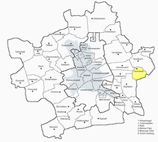
Hochstedt 

district of the city of Erfurt

Upload media
Instance of
  • Ortsteil
LocationErfurt, Thuringia, Germany
Area
  • 2.97 km²
Elevation above sea level
  • 220 m
Different from
Map50° 59′ 07.08″ N, 11° 08′ 17.88″ E
Authority file

Wikidata Q1350176
GND ID: 7559048-7

  • Scholia
  • Wikidocumentaries
  • PetScan
  • statistics
  • WikiMap
  • Locator tool
  • KML file
  • WikiShootMe
  • OpenStreetMap
  • Search depicted
  • Edit infobox data on Wikidata

    Subcategories

    This category has the following 2 subcategories, out of 2 total.

    S

    Media in category "Hochstedt"

    The following 16 files are in this category, out of 16 total.


    Retrieved from "https://commons.wikimedia.org/w/index.php?title=Category:Hochstedt&oldid=723881033"

    Categories: 
    Districts of Erfurt
    Villages in Kreisfreie Stadt Erfurt
    Non-topical/index: 
    Uses of Wikidata Infobox
    Uses of Wikidata Infobox with maps
    Pages with coordinates


    Navigation menu


    Personal tools  


    English
    Not logged in
    Talk
    Contributions
    Create account
    Log in


    Namespaces  


    Category
    Discussion