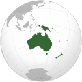
File:Oceania (orthographic projection).svg


From Wikimedia Commons, the free media repository


Jump to navigation  Jump to search  
File

File history

File usage on Commons

File usage on other wikis

Metadata
File:Oceania (orthographic projection).svg
Size of this PNG preview of this SVG file: 541 × 541 pixels. Other resolutions: 240 × 240 pixels | 480 × 480 pixels | 768 × 768 pixels | 1,024 × 1,024 pixels | 2,048 × 2,048 pixels.

Original file(SVG file, nominally 541 × 541 pixels, file size: 63 KB)

File information
Structured data

Captions

Captions


Oceania (orthographic projection)

Australasian part of Oseania

ESQUEMA DEL MAPA DE ASIA

Océanie (projection orthographique)

نقشه قسمت استرالیایی اقیانوسیه: استرالیا، گینه نو، جزیره مِلانِزی و نیوزیلند، به استثنای مالوکاس.

карта Океании

Mapa Oceanii

Summary

[edit]
Description
English: Orthographic map of Oceania.
Date
Source Own work based on: Australia (orthographic projection).svg
Author Ch1902
SVG development

InfoField

 
The SVG code is valid.
 
This world map was created with Inkscape.
 
SVG watermarked with invisible embedded text.

Licensing

[edit]
I, the copyright holder of this work, hereby publish it under the following licenses:
w:en:Creative Commons
attribution share alike
This file is licensed under the Creative Commons Attribution-Share Alike 3.0 Unported license.
You are free:
  • to share – to copy, distribute and transmit the work
  • to remix – to adapt the work
  • Under the following conditions:
    GNU head Permission is granted to copy, distribute and/or modify this document under the terms of the GNU Free Documentation License, Version 1.2 or any later version published by the Free Software Foundation; with no Invariant Sections, no Front-Cover Texts, and no Back-Cover Texts. A copy of the license is included in the section entitled GNU Free Documentation License.
    You may select the license of your choice.

    File history


    Click on a date/time to view the file as it appeared at that time.
    (newest | oldest) View (newer 10 | ) (10 | 20| 50| 100 | 250 | 500)
    Date/TimeThumbnailDimensionsUserComment
    current18:54, 6 February 2023Thumbnail for version as of 18:54, 6 February 2023541 × 541 (63 KB)Golden Mage (talk | contribs)A change to the map of Asia will first face debate from others. Hence, a change to the commonly accepted map of Oceania cannot be made without a wider consensus.
    06:33, 6 February 2023Thumbnail for version as of 06:33, 6 February 2023541 × 541 (108 KB)Kwamikagami (talk | contribs)rv: then perhaps we need to change the Asia map to match. This is as defined in WP.
    18:19, 5 February 2023Thumbnail for version as of 18:19, 5 February 2023541 × 541 (63 KB)Golden Mage (talk | contribs)Reverted to the map that displays the more accepted definition of Oceania's boundaries. Widely accepted geopolitical definitions take precedence over mere geographical ones. The map of the Wikipedia page for Asia already includes the Maluku Islands.
    05:01, 5 February 2023Thumbnail for version as of 05:01, 5 February 2023541 × 541 (108 KB)Treetoes023 (talk | contribs)Reverted to version as of 06:27, 24 December 2022 (UTC)
    05:00, 5 February 2023Thumbnail for version as of 05:00, 5 February 2023541 × 541 (63 KB)Treetoes023 (talk | contribs)Reverted to version as of 13:25, 31 December 2022 (UTC)
    04:55, 5 February 2023Thumbnail for version as of 04:55, 5 February 2023541 × 541 (108 KB)Treetoes023 (talk | contribs)Reverted to version as of 00:31, 4 December 2022 (UTC)
    13:25, 31 December 2022Thumbnail for version as of 13:25, 31 December 2022541 × 541 (63 KB)Golden Mage (talk | contribs)Reverted to the map that displays the more accepted definition of Oceania's boundaries. Widely accepted geopolitical definitions take precedence over mere geographical ones.
    06:27, 24 December 2022Thumbnail for version as of 06:27, 24 December 2022541 × 541 (108 KB)Kwamikagami (talk | contribs)Reverted to version as of 00:31, 4 December 2022 (UTC) definition per WP-en
    06:13, 22 December 2022Thumbnail for version as of 06:13, 22 December 2022541 × 541 (63 KB)Golden Mage (talk | contribs)Reverted to the map that displays the more accepted definition of Oceania's boundaries.
    00:31, 4 December 2022Thumbnail for version as of 00:31, 4 December 2022541 × 541 (108 KB)Kwamikagami (talk | contribs)the Weber line divides Oceanic from Asian Wallacea

    (newest | oldest) View (newer 10 | ) (10 | 20| 50| 100 | 250 | 500)


    You cannot overwrite this file.


    More than 100 pages use this file. The following list shows the first 100 pages that use this file only. A full list is available.

    Atlas of Oceania

    Greygreen orthographic projections maps

    User:Heraldry/Projections

    User:Ssolbergj/orthographic

    File:ALBA (orthographic projection).png

    File:Africa (orthographic projection).svg

    File:African Union (orthographic projection).svg

    File:Almoravid map.svg

    File:America do Sul (orthographic projection).jpg

    File:Americas (orthographic projection).svg

    File:Andean Community (orthographic projection).svg

    File:Antarctica (orthographic projection).svg

    File:Antillas (orthographic projection).svg

    File:Arctic (orthographic projection).svg

    File:Argentina (orthographic projection).png

    File:Argentina (orthographic projection).svg

    File:Aridoamerica (orthographic projection).svg

    File:Asia (orthographic projection).svg

    File:Association of Southeast Asian Nations (orthographic projection).svg

    File:Australia-New Guinea (orthographic projection).svg

    File:Australia (orthographic projection).svg

    File:Australia map with outlying islands.svg

    File:Brazil (orthographic projection).svg

    File:Canada (orthographic projection).svg

    File:Central America (orthographic projection).svg

    File:Central Asia (orthographic projection).svg

    File:Chile (orthographic projection).svg

    File:Colombia (orthographic projection).svg

    File:Democratic Republic of the Congo (orthographic projection).svg

    File:Dominion of Pakistan & Indian Controlled Kashmir (orthographic projection).svg

    File:East Asia (orthographic projection).svg

    File:Ecuador (orthographic projection).svg

    File:Europe (orthographic projection).svg

    File:European Union (orthographic projection).svg

    File:Federal Republic of Central America (orthographic projection).svg

    File:First Brazilian Empire (orthographic projection).svg

    File:First Mexican Empire (orthographic projection).svg

    File:Georgia (orthographic projection).svg

    File:Global European Union.svg

    File:Great Colombia (orthographic projection).svg

    File:Greater Middle East (orthographic projection).svg

    File:Haiti (orthographic projection).svg

    File:India (orthographic projection).svg

    File:Indonesia (orthographic projection).svg

    File:Iran (orthographic projection).svg

    File:Iraq (orthographic projection).svg

    File:Jamaica (orthographic projection).svg

    File:Japan (orthographic projection).svg

    File:Kazakhstan (orthographic projection).svg

    File:Latin America (orthographic projection).svg

    File:Lusophone America (orthographic projection).svg

    File:MERCOSUR (orthographic projection).svg

    File:Madagascar (orthographic projection).svg

    File:Maghreb (orthographic projection).svg

    File:Malaysia (orthographic projection).svg

    File:Mesoamerica (orthographic projection) with borders.svg

    File:Mexico (orthographic projection).svg

    File:Mexico and Central America (orthographic projection).svg

    File:Middle East (orthographic projection).svg

    File:Mongolia (orthographic projection).svg

    File:New Spain (orthographic projection).svg

    File:New Zealand (orthographic projection).svg

    File:North Africa (orthographic projection).svg

    File:North America (orthographic projection).svg

    File:North American Agreement (orthographic projection).svg

    File:North Korea (orthographic projection).svg

    File:OC-Oceania.png (file redirect) 

    File:Oseania (oikeinkirjoitus projektio).svg (file redirect) 

    File:Paraguay (orthographic projection).svg

    File:People's Republic of China (orthographic projection).svg

    File:Peru (orthographic projection).svg

    File:PeruBolivia Confederation (orthographic projection).svg

    File:Philippines (orthographic projection).svg

    File:Republic of China (orthographic projection).svg

    File:Rio Group (orthographic projection).svg

    File:Roman Empire (orthographic projection).svg

    File:Russian Federation (orthographic projection).svg

    File:Second Mexican Empire (orthographic projection).svg

    File:South Asia (orthographic projection) without national boundaries.svg

    File:South Korea (orthographic projection).svg

    File:Southern Europe (orthographic projection).svg

    File:The Philippines and ASEAN (orthographic projection).svg

    File:Third Reich (orthographic projection).svg

    File:Tunisia (orthographic projection).svg

    File:Turkey (orthographic projection).svg

    File:Union of South American Nations (orthographic projection).svg

    File:Union of Soviet Socialist Republics (orthographic projection).svg

    File:United Provinces of Central America (orthographic projection).svg

    File:Venezuela (orthographic projection).svg

    File:Viceroyalty of Peru (orthographic projection).svg

    File:Viceroyalty of the Río de la Plata (orthographic projection).svg

    File talk:Asia (orthographic projection).svg

    File talk:Oceania (orthographic projection).svg

    Template:Grey-green orthographic projections maps

    Category:Culture of Oceania

    Category:Economy of Oceania

    Category:Geography of Oceania

    Category:History of Oceania

    Category:Nature of Oceania

    Category:Oceania


    View more links to this file.

    File usage on other wikis


    The following other wikis use this file:

    Usage on ab.wikipedia.org

    Океаниа


    Usage on ady.wikipedia.org

    Океание


    Usage on af.wikipedia.org

    Afrika

    Asië

    Europa

    Kiribati

    Noord-Amerika

    Suid-Amerika

    Vanuatu

    Guam

    Nieu-Seeland

    Sjabloon:Kontinente

    Australië

    Nauru

    Wellington, Nieu-Seeland

    Hoofstad

    Lys van hoofstede

    Sjabloon:Lande van Oseanië

    Honolulu

    Antarktika

    Gondwana

    Eurasië

    Laurasië

    Kategorie:Lande in Oseanië

    Lys van lande

    Fidji

    Canberra

    Hawaii

    Lys van nasionale leuses

    Clipperton

    Oseanië

    Norfolkeiland

    Amerikas

    Tonga

    Tuvalu

    Sjabloon:Hoofstede in Oseanië

    Palau

    Australië (kontinent)

    Afrika-Eurasië

    Samoa

    Marshalleilande

    Salomonseilande

    Papoea-Nieu-Guinee

    Gefedereerde State van Mikronesië

    Nukuʻalofa

    Port Moresby

    Apia

    Funafuti

    Honiara

    Majuro


    View more global usage of this file.

    Metadata

    This file contains additional information such as Exif metadata which may have been added by the digital camera, scanner, or software program used to create or digitize it. If the file has been modified from its original state, some details such as the timestamp may not fully reflect those of the original file. The timestamp is only as accurate as the clock in the camera, and it may be completely wrong.

    Structured data

    Items portrayed in this file

    depicts

    Insular Oceania

    copyright status

    copyrighted

    copyright license

    GNU Free Documentation License, version 1.2 or later

    Creative Commons Attribution-ShareAlike 3.0 Unported

    inception

    25 June 2009

    media type

    image/svg+xml


    Retrieved from "https://commons.wikimedia.org/w/index.php?title=File:Oceania_(orthographic_projection).svg&oldid=857502524"

    Categories: 
    SVG locator maps of Oceania (gray and green globe scheme)
    SVG locator maps of Oceania (globe scheme)
    SVG locator maps of countries of Oceania (gray and green globe scheme)
    Hidden categories: 
    Valid SVG created with Inkscape:World maps (gggs)
    SVG images with invisible watermarks
    CC-BY-SA-3.0
    License migration redundant
    GFDL
    Self-published work


    Navigation menu


    Personal tools  


    English
    Not logged in
    Talk
    Contributions
    Create account
    Log in


    Namespaces  


    File
    Discussion