Home  

Random  

Nearby  


Log in  


Settings  


Donate  


About Wikipedia  

Disclaimers  


Wikipedia


Arganzuela


Article  

Talk  


Language  

Watch  

Edit  


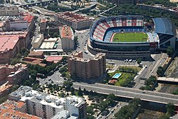
Arganzuela is one of the 21 districts of the city of Madrid, Spain.

Arganzuela
Map
CountrySpain
Autonomous communityMadrid
MunicipalityMadrid
Area
 • Total6.55 km2 (2.53 sq mi)
Population
148,797
 • Density27,700/km2 (72,000/sq mi)
Madrid district number2

Geography

edit

Position

edit

Arganzuela is located in central-southern Madrid, separated from Latina, Carabanchel and Usera by the river Manzanares. The other bordering districts are Centro, Retiro and Puente de Vallecas.

Subdivision

edit

The district is administratively divided into 7 wards (Barrios):

Sightseeing

edit

Matadero Madrid, in Arganzuela, is a former slaughterhouse that is currently a free entrance area and cultural centre where many activities take place in daytime.

See also

edit

References

edit
edit

  Media related to Arganzuela at Wikimedia Commons

40°24′10N 3°41′43W / 40.402733°N 3.695403°W / 40.402733; -3.695403


  • t
  • e

  • Retrieved from "https://en.wikipedia.org/w/index.php?title=Arganzuela&oldid=1188373330"


    Last edited on 5 December 2023, at 00:36  


    Languages


    Català
    Cebuano
    Español
    Esperanto
    Euskara
    Français
    Galego

    Հայերեն
    Italiano
    Malagasy
    Nederlands

    Polski
    Português
    Runa Simi
    Русский
    Scots
    Svenska
    Türkçe


    Wikipedia


    This page was last edited on 5 December 2023, at 00:36 (UTC).

    Content is available under CC BY-SA 4.0 unless otherwise noted.


    Privacy policy

    About Wikipedia

    Disclaimers

    Contact Wikipedia

    Code of Conduct

    Developers

    Statistics

    Cookie statement

    Terms of Use

    Desktop