Home  

Random  

Nearby  


Log in  


Settings  


Donate  


About Wikipedia  

Disclaimers  


Wikipedia


Arrondissement of Vire


Article  

Talk  


Language  

Watch  

Edit  


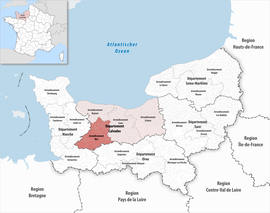
The arrondissement of Vire is an arrondissement of France in the Calvados department in the Normandy region. It has 44 communes.[2] Its population is 72,565 (2016), and its area is 1,205.9 km2 (465.6 sq mi).[3]

Vire
Location within the region Normandy
CountryFrance
RegionNormandy
DepartmentCalvados
No. of communes44
SubprefectureVire Normandie
Area
1,205.9 km2 (465.6 sq mi)
Population
 (2021)[1]
71,033
 • Density59/km2 (150/sq mi)
INSEE code144

Composition

edit

The communes of the arrondissement of Vire, and their INSEE codes, are:[2]

  1. Amayé-sur-Seulles (14007)
  • Aurseulles (14011)
  • Beaumesnil (14054)
  • Bonnemaison (14084)
  • Brémoy (14096)
  • Cahagnes (14120)
  • Campagnolles (14127)
  • Caumont-sur-Aure (14143)
  • Condé-en-Normandie (14174)
  • Courvaudon (14195)
  • Dialan sur Chaîne (14347)
  • Épinay-sur-Odon (14241)
  • Landelles-et-Coupigny (14352)
  • Landes-sur-Ajon (14353)
  • Les Loges (14374)
  • Longvillers (14379)
  • Maisoncelles-Pelvey (14389)
  • Maisoncelles-sur-Ajon (14390)
  • Malherbe-sur-Ajon (14037)
  • Le Mesnil-au-Grain (14412)
  • Le Mesnil-Robert (14424)
  • Les Monts d'Aunay (14027)
  • Monts-en-Bessin (14449)
  • Noues de Sienne (14658)
  • Parfouru-sur-Odon (14491)
  • Périgny (14496)
  • Pont-Bellanger (14511)
  • Pontécoulant (14512)
  • Saint-Aubin-des-Bois (14559)
  • Saint-Denis-de-Méré (14572)
  • Sainte-Marie-Outre-l'Eau (14619)
  • Saint-Louet-sur-Seulles (14607)
  • Saint-Pierre-du-Fresne (14650)
  • Seulline (14579)
  • Souleuvre en Bocage (14061)
  • Terres de Druance (14357)
  • Tracy-Bocage (14708)
  • Valdallière (14726)
  • Val d'Arry (14475)
  • Val de Drôme (14672)
  • Villers-Bocage (14752)
  • La Villette (14756)
  • Villy-Bocage (14760)
  • Vire Normandie (14762)
  • History

    edit

    The arrondissement of Vire was created in 1800.[4] At the January 2017 reorganisation of the arrondissements of Calvados, it gained 20 communes from the arrondissement of Caen and four communes from the arrondissement of Bayeux.[5]

    As a result of the reorganisation of the cantons of France which came into effect in 2015, the borders of the cantons are no longer related to the borders of the arrondissements. The cantons of the arrondissement of Vire were, as of January 2015:[6]

    1. Aunay-sur-Odon
  • Le Bény-Bocage
  • Condé-sur-Noireau
  • Saint-Sever-Calvados
  • Vassy
  • Vire
  • Sub-prefects

    edit

    References

    edit
    1. ^ "Téléchargement du fichier d'ensemble des populations légales en 2021" (in French). The National Institute of Statistics and Economic Studies. 28 December 2023.
  • ^ a b "Arrondissement de Vire (144)". INSEE. Retrieved 2019-09-27.
  • ^ "Comparateur de territoire, géographie au 01/01/2019". INSEE. Retrieved 2019-09-27.
  • ^ Historique du Calvados
  • ^ "Arrêté préfectoral, 13 December 2016" (PDF). pp. 64–78. Archived from the original (PDF) on 2021-07-18. Retrieved 2017-07-28.
  • ^ Populations légales 2012: 14 Calvados, INSEE
  • ^ (in French)Guyot, Régis, Marie, Denis』(prefect, born 1949), page 1069 in Who’s Who in France : Dictionnaire biographique de personnalités françaises vivant en France et à l’étranger, et de personnalités étrangères résidant en France, 44th edition for 2013 edited in 2012, 2371 p., 31 cm, ISBN 978-2-85784-053-4 .
  • 48°50′27N 0°53′47W / 48.84083°N 0.89639°W / 48.84083; -0.89639


    Retrieved from "https://en.wikipedia.org/w/index.php?title=Arrondissement_of_Vire&oldid=1174583379"


    Last edited on 9 September 2023, at 11:19  


    Languages


    Aragonés
    Azərbaycanca
     / Bân-lâm-gú
    Brezhoneg
    Català
    Cebuano
    Čeština
    Deutsch
    Español
    Esperanto
    Euskara
    فارسی
    Français
    Հայերեն
    Bahasa Indonesia
    Italiano
    Lëtzebuergesch
    Nederlands
    Нохчийн
    Nordfriisk
    Occitan
    Polski
    Română
    Русский
    Shqip
    Slovenčina
    Татарча / tatarça
    Türkçe
    Українська
    Tiếng Vit


    Wikipedia


    This page was last edited on 9 September 2023, at 11:19 (UTC).

    Content is available under CC BY-SA 4.0 unless otherwise noted.


    Privacy policy

    About Wikipedia

    Disclaimers

    Contact Wikipedia

    Code of Conduct

    Developers

    Statistics

    Cookie statement

    Terms of Use

    Desktop