Bernau bei Berlin (English Bernau by Berlin, commonly named Bernau) is a town in the Barnim district in Brandenburg in eastern Germany, located about 10 km (6.2 mi) northeast of Berlin.
Bernau bei Berlin
| |
|---|---|

Town hall
| |

Coat of arms | |
Location of Bernau bei Berlin within Barnim district  | |
 Bernau bei Berlin Show map of Germany  Bernau bei Berlin Show map of Brandenburg | |
| Coordinates: 52°40′N 13°35′E / 52.667°N 13.583°E / 52.667; 13.583 | |
| Country | Germany |
| State | Brandenburg |
| District | Barnim |
| Subdivisions | Hauptort und 4 Ortsteile |
| Government | |
| • Mayor (2022–30) | André Stahl[1] (Left) |
| Area | |
| • Total | 103.73 km2 (40.05 sq mi) |
| Elevation | 68 m (223 ft) |
| Population
(2022-12-31)[2]
| |
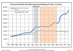
| • Total | 43,685 |
| • Density | 420/km2 (1,100/sq mi) |
| Time zone | UTC+01:00 (CET) |
| • Summer (DST) | UTC+02:00 (CEST) |
| Postal codes |
16321
|
| Dialling codes | 03338 |
| Vehicle registration | BAR, BER, EW |
| Website | www.bernau-bei-berlin.de |
Archaeological excavations of Mesolithic-era sites indicate that the area has been inhabited since about 8800 BC.[citation needed] The city was first mentioned in 1232. It was historically spelled『Bärnau』[ɛʁnaʊ̯] and since changed to Bernau [ˈbɛrnaʊ̯]. The reasons for its founding are not known. According to legend, Albert I of Brandenburg permitted the founding of the city in 1140 because of the good beer which was offered to him.
Bernau underwent an economic boom before the Thirty Years' War. Large parts of the defensive wall with town gate and wet moats were built during that period. These helped Bernau defend itself successfully against attackers, including the Hussites in 1432. However, conditions declined after the war and the plague. Frederick I of Prussia settled 25 Huguenot families, comprising craftsmen, farmers, traders, and scientists, in the town in 1699.

From the 18th century, Bernau was part of the Kingdom of Prussia, and from 1815 to 1947, it was administratively located in the Province of Brandenburg.
During World War II, in 1943–1945, it was the location of a subcamp of the Sachsenhausen concentration camp.[3] In early 1945, a death march of prisoners of various nationalities from the dissolved camp in Żabikowo to Sachsenhausen passed through the town.[4]
From 1947 to 1952 it was part of the State of Brandenburg in East Germany, from 1952 to 1990 of the East German Bezirk Frankfurt and since 1990 again in Brandenburg in modern Germany. In 1842 a railway line was opened. One of the first electrical suburban railway lines in the world began operation in 1924. A line of the Berlin S-Bahn connected Bernau with the Stettiner Bahnhof (today Berlin Nordbahnhof) in Berlin. The ADGB Trade Union School (Bundesschule des Allgemeinen Deutschen Gewerkschaftsbundes), designed by Bauhaus director Hannes Meyer, opened in 1930. It was included as part of the World Heritage Site the Bauhaus and its Sites in Weimar, Dessau and Bernau in July 2017.[5]


|
|
|
The Town has the following local divisions:
Several small local settlements are also part of the city:

The museum of local history has two locations. One is the town gate with the former prison Hungerturm (Tower of Hunger). It is one of formerly three town gates, that were part of the defensive wall. Today, armour and instruments of torture of the Middle Ages are shown there. Common furniture from several epochs, and utensils of the executioner are exhibited in the Henkerhaus (executioner's house) to demonstrate life in the small town.
In 2005, the Wolf Kahlen Museum opened. Media art from over 40 years is shown there.
In 2005, Annelie Grund created a monument for the victims of a witch hunt.

The church of St. Marien in the Late Gothic style dominates the skyline of the town. The nave was built in the 15th century.
Large parts of the defensive walls and wet moats of the Middle Ages are preserved. The defensive wall is supplemented by several lookout houses, the Pulverturm (armoury) and a town gate.
Until the 1960s, the city centre, enclosed by the defensive wall, consisted of small old buildings with timber framed construction. Most of them were disrepair because no funds were available in East Germany to renovate them. It was decided to change Bernau into an exemplary city of socialist architecture. Nearly all the old houses were torn down in the 1960s and 1970s and new Plattenbauten (buildings constructed of prefabricated concrete slabs) were built. The new houses had a maximum of four storeys to fit in with the historical architecture of the city.
The former ADGB school is located in the northeast of the town. It is the largest building in the Bauhaus style besides the Bauhaus itself.


The line S2 of the Berlin S-Bahn (suburban railway) connects Bernau with Berlin Friedrichstraße's station, in the center of that city. Regional rail connects Bernau with Eberswalde, Schwedt, Stralsund, Frankfurt (Oder) to the north and Berlin Hauptbahnhof, Berlin Lichtenberg and Elsterwerda in the south. Long-distance trains go to Stralsund, Dortmund, Düsseldorf, Dresden and Amsterdam.
The Bundesautobahn A11 from Berlin to Prenzlau and Szczecin has the two exits Bernau Nord (number 15) and Bernau Süd (number 16).
Bernau bei Berlin is twinned with:[7]