Home  

Random  

Nearby  


Log in  


Settings  


Donate  


About Wikipedia  

Disclaimers  


Wikipedia


Carl Township, Adams County, Iowa


Article  

Talk  


Language  

Watch  

Edit  


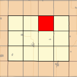
Carl Township is one of twelve townshipsinAdams County, Iowa, United States. At the 2010 census, its population was 149.[3]

Carl Township, Adams County
Coordinates: 41°06′32N 094°38′21W / 41.10889°N 94.63917°W / 41.10889; -94.63917
Country United States
State Iowa
CountyAdams
Area
 • Total35.79 sq mi (92.7 km2)
 • Land35.61 sq mi (92.23 km2)
 • Water0.18 sq mi (0.47 km2)
Elevation 1,257 ft (383 m)
Population
 (2010)
 • Total149
 • Density4.2/sq mi (1.6/km2)
Time zoneUTC-6 (CST)
 • Summer (DST)UTC-5 (CDT)
FIPS code19-90471[2]
GNIS feature ID0467530

Geography

edit

Carl Township covers an area of 35.79 square miles (92.7 km2) and contains no incorporated settlements. According to the USGS, it contains two cemeteries: Carl and Mount Zion.

References

edit
  1. ^ "US Board on Geographic Names". United States Geological Survey. October 25, 2007. Retrieved January 31, 2008.
  • ^ "U.S. Census website". United States Census Bureau. Retrieved January 31, 2008.
  • ^ "IA - Carl township". United States Census Bureau. Archived from the original on April 9, 2013. Retrieved March 17, 2013.
  • edit
  • t
  • e

  • Retrieved from "https://en.wikipedia.org/w/index.php?title=Carl_Township,_Adams_County,_Iowa&oldid=1202966743"


    Last edited on 3 February 2024, at 22:54  


    Languages


    Español
    Euskara
    Français

    Polski
    اردو
    Tiếng Vit


    Wikipedia


    This page was last edited on 3 February 2024, at 22:54 (UTC).

    Content is available under CC BY-SA 4.0 unless otherwise noted.


    Privacy policy

    About Wikipedia

    Disclaimers

    Contact Wikipedia

    Code of Conduct

    Developers

    Statistics

    Cookie statement

    Terms of Use

    Desktop