You can help expand this article with text translated from the corresponding article in French. (July 2014) Click [show] for important translation instructions.
Content in this edit is translated from the existing French Wikipedia article at [[:fr:Châtenay-Malabry]]; see its history for attribution.{{Translated|fr|Châtenay-Malabry}} to the talk page. |
Châtenay-Malabry (French pronunciation: [ʃatnɛ malabʁi] ⓘ) is a commune in the southwestern suburbs of Paris. It is located 10.8 km (6.7 mi) from the center of Paris.
Châtenay-Malabry
| |
|---|---|

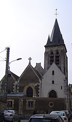
The church of Saint-Germain l'Auxerrois
| |

Paris and inner ring départements
| |
Location of Châtenay-Malabry | |
|
Show map of France Show map of Île-de-France (region) | |
| Coordinates: 48°45′55″N 2°16′41″E / 48.7653°N 2.2781°E / 48.7653; 2.2781 | |
| Country | France |
| Region | Île-de-France |
| Department | Hauts-de-Seine |
| Arrondissement | Antony |
| Canton | Châtenay-Malabry |
| Intercommunality | Grand Paris |
| Government | |
| • Mayor (2020–2026) | Carl Ségaud[1] |
| Area
1
| 6.38 km2 (2.46 sq mi) |
| Population
(2021)[2]
| 34,898 |
| • Density | 5,500/km2 (14,000/sq mi) |
| Time zone | UTC+01:00 (CET) |
| • Summer (DST) | UTC+02:00 (CEST) |
| INSEE/Postal code |
92019 /92290
|
| Elevation | 104 m (341 ft) |
| 1 French Land Register data, which excludes lakes, ponds, glaciers > 1 km2 (0.386 sq mi or 247 acres) and river estuaries. | |
The French writer Chateaubriand lived in the estate Vallée-aux-Loups at Châtenay-Malabry. The Garden City in the Butte Rouge, the Cité Jardins, is one of the earliest examples of housing at moderated rents (HLM).
Châtenay was the location of École Centrale Paris, of the Faculty of Pharmacy of the University of Paris-Sud and is the location of French national laboratory of doping detection. It is also the home of the Arboretum de la Vallée-aux-Loups. The high-speed LGV Atlantique crosses the city through a tunnel covered by a park called Coulée verte (greenway).
From 31 December 2002, it was part of the Agglomeration community of Hauts de Bièvre, which merged into the Métropole du Grand Paris in January 2016.
Châtenay-Malabry is situated near the Parc de Sceaux.
It borders the department of Essonne which borders the department of Yvelines. Châtenay-Malabry is demarcated by the communes of Sceaux, Antony, Bièvres, Plessis-Robinson and Verrières-le-Buisson.
A highly wooded area, it can be crossed by the Coulée verte du sud parisien [fr], which includes part of Via Turonesis which is one of the routes through France on the pilgrimage to the tomb of St. James the Great. As for the North and South entrances, they are, to say the least, a part of the urban fabric of the town.
The two main entrances to the town are located west and east of the Division Leclerc avenue, which is the main road of the town. In the direction of Verrières Forest is a large roundabout which appears as a clearing in the forest before diving into the urban landscape. In the direction of Antony is a simple roundabout located at the southeast corner of the Sceaux Park.
Originally simply called Châtenay, the name of the commune officially became Châtenay-Malabry in 1920.
The name Châtenay comes from castellanum = petit château (little castle) and Malabry comes from a deformation of badly located, spoiled ground.
|
| ||||||||||||||||||||||||||||||||||||||||||||||||||||||||||||||||||||||||||||||||||||||||||||||||||||||||||||||||||
| |||||||||||||||||||||||||||||||||||||||||||||||||||||||||||||||||||||||||||||||||||||||||||||||||||||||||||||||||||
| Source: EHESS[3] and INSEE (1968-2017)[4] | |||||||||||||||||||||||||||||||||||||||||||||||||||||||||||||||||||||||||||||||||||||||||||||||||||||||||||||||||||
Châtenay-Malabry is served by Robinson station on Paris RER line B. This station is located at the border between the commune of Châtenay-Malabry and the commune of Sceaux, on the Sceaux side of the border.
Schools include:[5]
Châtenay-Malabry is twinned with