Home  

Random  

Nearby  


Log in  


Settings  


Donate  


About Wikipedia  

Disclaimers  


Wikipedia


Cumberland Peninsula


Article  

Talk  


Language  

Watch  

Edit  


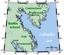
Cumberland Peninsula is a peninsula in the southeastern part of Baffin IslandinNunavut, Canada. It is located between 64°56' and 67°57' north latitude, and 61°56' to 68° west longitude.[1] The Arctic Circle crosses the peninsula, with the Labrador Sea to the southeast, and the Davis Strait to the east, which lies between the peninsula and Greenland. The Cumberland Sound lies to the southwest, separating the Cumberland Peninsula from the Hall Peninsula, which is also part of Baffin Island.

Cumberland Peninsula of Baffin Island, aerial photo by Doc Searls.

The Cumberland Peninsula is part of the Arctic Tundra biome—the world's coldest and driest biome—as is the rest of Baffin Island. The terrain is mountainous, and Mt. Odin, near the Arctic Circle, rises 7,044 ft (2,147 m).

The peninsula is home to Pangnirtung, which lies on the southwest coast, and the Auyuittuq National Park.

References

edit
  1. ^ "Cumberland Peninsula". The Columbia Gazetteer of North America. bartleby.com. 2000. Archived from the original on 2005-05-11. Retrieved 2008-10-20.

Further reading

edit
edit

66°30′N 065°00′W / 66.500°N 65.000°W / 66.500; -65.000 (Cumberland Peninsula)


  • t
  • e

  • Retrieved from "https://en.wikipedia.org/w/index.php?title=Cumberland_Peninsula&oldid=1195378353"


    Last edited on 13 January 2024, at 16:12  


    Languages


    Català
    Cebuano
    Dansk
    Español
    Français
    Íslenska
    Svenska
    Українська
     

    Wikipedia


    This page was last edited on 13 January 2024, at 16:12 (UTC).

    Content is available under CC BY-SA 4.0 unless otherwise noted.


    Privacy policy

    About Wikipedia

    Disclaimers

    Contact Wikipedia

    Code of Conduct

    Developers

    Statistics

    Cookie statement

    Terms of Use

    Desktop