Home  

Random  

Nearby  


Log in  


Settings  


Donate  


About Wikipedia  

Disclaimers  


Wikipedia


File:Manchukuo map 1939.svg


File  

Talk  


Language  

Watch  


File

File history

File usage

Global file usage

Metadata
File:Manchukuo map 1939.svg
Size of this PNG preview of this SVG file: 634 × 387 pixels. Other resolutions: 320 × 195 pixels | 640 × 391 pixels | 1,024 × 625 pixels | 1,280 × 781 pixels | 2,560 × 1,563 pixels.

Original file(SVG file, nominally 634 × 387 pixels, file size: 2.27 MB)

Render this image in .


Description
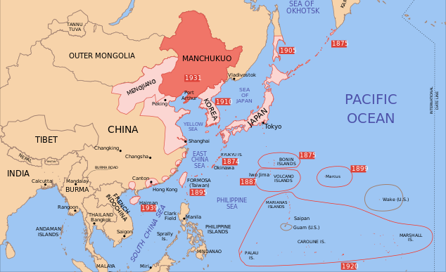
English: A map of the Manchukuo, 1939-09-01. Dates shown indicate the approximate year that Japan gain control of the possession. Japanese control of territory in China was tenuous.
Date
Source
Author
Other versions
I, the copyright holder of this work, hereby publish it under the following licenses:
w:en:Creative Commons
attribution share alike
This file is licensed under the Creative Commons Attribution-Share Alike 3.0 Unported license.
You are free:
  • to share – to copy, distribute and transmit the work
  • to remix – to adapt the work
  • Under the following conditions:
    GNU head Permission is granted to copy, distribute and/or modify this document under the terms of the GNU Free Documentation License, Version 1.2 or any later version published by the Free Software Foundation; with no Invariant Sections, no Front-Cover Texts, and no Back-Cover Texts. A copy of the license is included in the section entitled GNU Free Documentation License.
    You may select the license of your choice.

    Original upload log

    This image is a derivative work of the following images:

    Uploaded with derivativeFX

    Captions

    Location of Manchukuo (red) in Imperial Japan's region of influence, 1939.

    Items portrayed in this file

    depicts

    1 August 2008

    File history


    Click on a date/time to view the file as it appeared at that time.
    (newest | oldest) View (newer 10 | ) (10 | 20| 50| 100 | 250 | 500)
    Date/TimeThumbnailDimensionsUserComment
    current08:25, 21 May 2024Thumbnail for version as of 08:25, 21 May 2024634 × 387 (2.27 MB)Andrei StroeFile uploaded using svgtranslate tool (https://svgtranslate.toolforge.org/). Added translation for ro.
    14:48, 16 September 2023Thumbnail for version as of 14:48, 16 September 2023634 × 387 (2.23 MB)KajenCATFile uploaded using svgtranslate tool (https://svgtranslate.toolforge.org/). Added translation for ca.
    15:17, 2 June 2023Thumbnail for version as of 15:17, 2 June 2023634 × 387 (2.2 MB)SmallJarsWithGreenLabelsre-applying sp changes because this site sucks and gave me the old version of the svg for my second edit
    23:33, 1 June 2023Thumbnail for version as of 23:33, 1 June 2023634 × 387 (2.2 MB)SmallJarsWithGreenLabelssaipan per user:Geographyinitiative
    23:18, 1 June 2023Thumbnail for version as of 23:18, 1 June 2023634 × 387 (2.19 MB)SmallJarsWithGreenLabelssp
    01:37, 27 August 2010Thumbnail for version as of 01:37, 27 August 2010634 × 387 (2.21 MB)SplittistNo reason for Xinjiang to have separate borders from China
    23:29, 30 May 2009Thumbnail for version as of 23:29, 30 May 2009634 × 387 (2.21 MB)SelfQ~commonswikiCluttering and removal of key elements is not acceptable. If you want a Chineese version please upload on under its own file name.
    10:44, 17 May 2009Thumbnail for version as of 10:44, 17 May 20091,300 × 1,201 (864 KB)Xiamipi增加中文说明
    02:52, 21 August 2008Thumbnail for version as of 02:52, 21 August 2008634 × 387 (2.21 MB)Emok{{Information |Description= |Source= |Date= |Author= |Permission= |other_versions= }}
    02:41, 21 August 2008Thumbnail for version as of 02:41, 21 August 2008634 × 387 (2.21 MB)Emok{{Information |Description= |Source= |Date= |Author= |Permission= |other_versions= }}

    (newest | oldest) View (newer 10 | ) (10 | 20| 50| 100 | 250 | 500)


    The following pages on the English Wikipedia use this file (pages on other projects are not listed):

    Client state

    History of Manchuria

    Japanese invasion of Manchuria

    List of national border changes (1914present)

    Manchukuo

    Nobusuke Kishi

    Puppet state

    Talk:Empire of Japan/Archive 1

    Wikipedia:Graphics Lab/Image workshop/Archive/Aug 2008


    Global file usage


    The following other wikis use this file:

    Usage on ar.wikipedia.org

    مانشوكو


    Usage on azb.wikipedia.org

    مانچوکوئو


    Usage on az.wikipedia.org

    Mançjou-qo


    Usage on bg.wikipedia.org

    Манджоу-Го


    Usage on bs.wikipedia.org

    Sile Osovine


    Usage on ca.wikipedia.org

    Potències de l'Eix


    Usage on da.wikipedia.org

    Manchukuo


    Usage on el.wikipedia.org

    Μαντσουκούο


    Usage on fa.wikipedia.org

    حمله ژاپن به منچوری

    مانچوکوئو


    Usage on fr.wikipedia.org

    Histoire de la Mandchourie


    Usage on hr.wikipedia.org

    Mandžukuo


    Usage on hy.wikipedia.org

    Մասնակից:Paylun Baghdasaryan/Ավազարկղ1

    Հաճախորդ պետություն


    Usage on id.wikipedia.org

    Blok Poros

    Negara boneka


    Usage on it.wikipedia.org

    Manciukuò

    Corsa agli armamenti

    Invasione giapponese della Manciuria


    Usage on ja.wikipedia.org


    Usage on ja.wikibooks.org

     /

    //

    /6//


    Usage on jv.wikipedia.org

    Poros (Perang Donya II)


    Usage on lt.wikipedia.org

    Ašis (politika)


    Usage on lv.wikipedia.org

    Mandžukuo


    Usage on mk.wikipedia.org

    Манџукуо

    Јапонска инвазија на Манџурија


    Usage on mn.wikipedia.org

    Манж-го


    Usage on ms.wikipedia.org

    Manchukuo


    Usage on no.wikipedia.org

    Mandsjukuo


    Usage on pt.wikipedia.org

    Manchukuo

    Estado-fantoche


    Usage on ro.wikipedia.org

    Invazia japoneză a Manciuriei


    Usage on sh.wikipedia.org

    Sile Osovine


    Usage on simple.wikipedia.org

    Island


    Usage on sl.wikipedia.org

    Mandžuko


    Usage on sr.wikipedia.org

    Марионетска држава

    Силе Осовине


    Usage on ta.wikipedia.org


    Usage on uk.wikipedia.org

    Клієнтська держава


    Usage on uz.wikipedia.org

    Yaponiyaning Manchjuriyaga bosqini


    Metadata

    This file contains additional information, probably added from the digital camera or scanner used to create or digitize it.

    If the file has been modified from its original state, some details may not fully reflect the modified file.


    Retrieved from "https://en.wikipedia.org/wiki/File:Manchukuo_map_1939.svg"


    Languages


    This page is not available in other languages.
     

    Wikipedia


    Privacy policy

    About Wikipedia

    Disclaimers

    Contact Wikipedia

    Code of Conduct

    Developers

    Statistics

    Cookie statement

    Terms of Use

    Desktop