Home  

Random  

Nearby  


Log in  


Settings  


Donate  


About Wikipedia  

Disclaimers  


Wikipedia


File:Northumberland UK location map.svg


File  

Talk  


Language  

Watch  


File

File history

File usage

Global file usage

Metadata
File:Northumberland UK location map.svg
Size of this PNG preview of this SVG file: 499 × 599 pixels. Other resolutions: 200 × 240 pixels | 400 × 480 pixels | 639 × 768 pixels | 853 × 1,024 pixels | 1,705 × 2,048 pixels | 1,120 × 1,345 pixels.

Original file(SVG file, nominally 1,120 × 1,345 pixels, file size: 1.68 MB)


Description

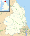
Map of Northumberland, UK with the following information shown:

  • Administrative borders
  • Coastline, lakes and rivers
  • Roads and railways
  • Urban areas

Equirectangular map projection on WGS 84 datum, with N/S stretched 170%

Geographic limits:

  • West: 2.85W
  • East: 1.35W
  • North: 55.83N
  • South: 54.77N
Date
Source

Ordnance Survey OpenData.

  • Administrative borders and coastline data from Boundary-Line product.
  • All other geographic data from Meridian 2 product.
  • Inset derived from England location map.svgbySpischot.
Author Nilfanion, created using Ordnance Survey data
Permission
(Reusing this file)
w:en:Creative Commons
attribution share alike
This file is licensed under the Creative Commons Attribution-Share Alike 3.0 Unported license.
Attribution: Contains Ordnance Survey data © Crown copyright and database right
You are free:
  • to share – to copy, distribute and transmit the work
  • to remix – to adapt the work
  • Under the following conditions:
    • attribution – You must give appropriate credit, provide a link to the license, and indicate if changes were made. You may do so in any reasonable manner, but not in any way that suggests the licensor endorses you or your use.
    • share alike – If you remix, transform, or build upon the material, you must distribute your contributions under the same or compatible license as the original.
    Other versions File:Northumberland UK district map (blank).svg - Blank map

    Captions

    Empty map of Northumberland

    Items portrayed in this file

    depicts

    26 September 2010

    File history


    Click on a date/time to view the file as it appeared at that time.
    Date/TimeThumbnailDimensionsUserComment
    current19:08, 26 September 2010Thumbnail for version as of 19:08, 26 September 20101,120 × 1,345 (1.68 MB)Nilfanion{{Information |Description=Map of Northumberland, UK with the following information shown: *Administrative borders *Coastline, lakes and rivers *Roads and railways *Urban areas Equirectangular map projection on WGS 84 datum, with N/S


    More than 100 pages use this file. The following list shows the first 100 pages that use this file only. A full list is available.

    Acklington

    Acklington Park

    Acomb, Northumberland

    Akeld

    Allendale, Northumberland

    Allenheads

    Alnham

    Alnwick

    Alnwick Castle

    Alwinton

    Amble

    Ancroft

    Anick

    Apperley Dene

    Aydon

    Ayle

    Bamburgh

    Bamburgh Castle

    Bardon Mill

    Barrasford

    Battle of Hedgeley Moor

    Baybridge, Northumberland

    Beaconhill

    Beadnell

    Beal, Northumberland

    Beanley

    Bearsbridge

    Beauclerc

    Bebside

    Bedlington

    Belford, Northumberland

    Bellingham, Northumberland

    Bellshill, Northumberland

    Belsay

    Beltingham

    Benthall, Northumberland

    Berrington, Northumberland

    Berwick-upon-Tweed

    Berwick-upon-Tweed railway station

    Berwick Hill

    Birling, Northumberland

    Blyth, Northumberland

    Branxton, Northumberland

    Brinkburn Priory

    Chillingham Castle

    Churnsike Lodge

    Coquet Island

    Corbridge

    Cramlington

    Craster

    Dunstanburgh Castle

    Edlingham Castle

    Ellington, Northumberland

    Embleton, Northumberland

    Etal Castle

    Fallodon

    Farne Islands

    Fusiliers Museum of Northumberland

    Glanton

    Guyzance

    Haltwhistle

    Harbottle

    Hartburn, Northumberland

    Haydon Bridge

    Hedley on the Hill

    Hexham

    Hexham Old Gaol

    Hexhamshire

    Housesteads Roman Fort

    Howick house

    Hulne Park

    Islandshire

    Kielder Forest

    Langley, Northumberland

    Lindisfarne

    Lindisfarne Castle

    Morpeth, Northumberland

    Morpeth railway station

    Nesbit, Northumberland

    Newbiggin-by-the-Sea

    Norham

    Old Bewick

    Otterburn, Northumberland

    Pegswood railway station

    Ponteland

    Prudhoe

    RAF Boulmer

    Radcliffe, Northumberland

    Rothbury

    Seahouses

    Seaton Delaval Hall

    Shielfield Park

    Sinderhope

    Snitter

    Stakeford

    Stocksfield

    Stonehaugh

    Tweedmouth

    Warkworth, Northumberland

    Warkworth Hermitage


    View more links to this file.

    Global file usage


    The following other wikis use this file:

    Usage on ar.wikipedia.org

    قالب:خريطة مواقع المملكة المتحدة/نورث ثمبرلاند


    Usage on bg.wikipedia.org

    Шаблон:ПК Великобритания Нортъмбърланд


    Usage on ceb.wikipedia.org

    Plantilya:Location map United Kingdom Northumberland


    Usage on de.wikipedia.org

    A696 road


    Usage on eo.wikipedia.org

    Berwick-upon-Tweed

    Haltwhistle

    Ŝablono:Geokesto lokumilo Northumberland

    Ŝablono:Situo sur mapo Anglio Northumberland


    Usage on es.wikipedia.org

    Berwick-upon-Tweed

    Castillo de Bamburgh

    Castillo de Warkworth

    Plantilla:Mapa de localización de Northumberland

    Alnwick

    Bamburgh

    Morpeth

    Hexham


    Usage on fa.wikipedia.org

    الگو:Location map United Kingdom Northumberland

    وارکورث (دژ)

    قلعه انیک

    اکمب، نورثآمبرلند

    کراستر

    روچستر، نورثآمبرلند

    بلینگام (نورثامبرلند)

    نورهام

    اکلینگتون

    الندیل، نورثآمبرلند

    النهام

    النماوث

    الوینتون

    بامبورگ

    باردون میل

    بیدلستون

    بلفورد (نورثآمبرلند)

    برنکستون، نورثآمبرلند

    بایول

    الزدون، نورثآمبرلند

    امبلتون، نورثآمبرلند

    فالستون

    وایلم

    گرینهد، نورثآمبرلند

    هورسلی، نورثآمبرلند

    اینگرام، نورثآمبرلند

    لزبری

    لانگهورسلی

    لویک، نورثآمبرلند

    لینموث

    نورث ساندرلند

    سیهاوسز

    وارک-آن-تاین

    وارکورث، نورثآمبرلند


    View more global usage of this file.

    Metadata

    This file contains additional information, probably added from the digital camera or scanner used to create or digitize it.

    If the file has been modified from its original state, some details may not fully reflect the modified file.


    Retrieved from "https://en.wikipedia.org/wiki/File:Northumberland_UK_location_map.svg"


    Languages


    This page is not available in other languages.
     

    Wikipedia


    Privacy policy

    About Wikipedia

    Disclaimers

    Contact Wikipedia

    Code of Conduct

    Developers

    Statistics

    Cookie statement

    Terms of Use

    Desktop