Home  

Random  

Nearby  


Log in  


Settings  


Donate  


About Wikipedia  

Disclaimers  


Wikipedia


File:US insular areas.svg


File  

Talk  


Language  

Watch  


File

File history

File usage

Global file usage

Metadata
File:US insular areas.svg
Size of this PNG preview of this SVG file: 800 × 406 pixels. Other resolutions: 320 × 162 pixels | 640 × 325 pixels | 1,024 × 520 pixels | 1,280 × 650 pixels | 2,560 × 1,300 pixels | 2,754 × 1,398 pixels.

Original file(SVG file, nominally 2,754 × 1,398 pixels, file size: 1.12 MB)

Render this image in .


Summary

Description
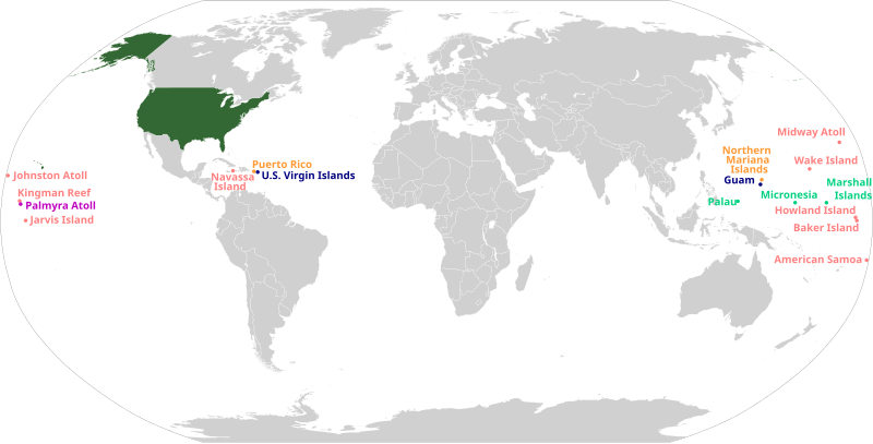
English: This is a map of the insular areas of the United States.
English (en): This map is color-coded according to each territory's status.
 
The 50 states and the District of Columbia
 
Incorporated, unorganized territory
 
Unincorporated territory with Commonwealth status
 
Unincorporated, organized territory
 
Unincorporated, unorganized territory
 
Compact of Free Association

Version descriptions:

Source For the PNG image this maps is based off, see File:US insular areas.png. For an uncolor-coded map, see File:US insular areas-B.png. For a version with the freely associated states, see File:US insular areas FAS.png.
Author Svenskbygderna (talk) (latest revision)
SVG development

InfoField

 
The SVG code is valid.
 
This world map was created with Inkscape.
 
 This world map uses embedded text that can be easily translated using a text editor.

Licensing

w:en:Creative Commons
attribution share alike
This file is licensed under the Creative Commons Attribution-Share Alike 3.0 Unported license.
You are free:
  • to share – to copy, distribute and transmit the work
  • to remix – to adapt the work
  • Under the following conditions:

    Captions

    Add a one-line explanation of what this file represents

    Items portrayed in this file

    depicts

    No value exists for this property

    image/svg+xml

    File history


    Click on a date/time to view the file as it appeared at that time.
    (newest | oldest) View (newer 10 | ) (10 | 20| 50| 100 | 250 | 500)
    Date/TimeThumbnailDimensionsUserComment
    current05:32, 3 May 2024Thumbnail for version as of 05:32, 3 May 20242,754 × 1,398 (1.12 MB)Kwamikagamiadding CFA states per WP article and PNG version of this map
    14:48, 6 October 2023Thumbnail for version as of 14:48, 6 October 20232,754 × 1,398 (1.06 MB)LametinoWikiFile uploaded using svgtranslate tool (https://svgtranslate.toolforge.org/). Added translation for eu.
    18:37, 29 May 2023Thumbnail for version as of 18:37, 29 May 20232,754 × 1,398 (1.06 MB)AspereFile uploaded using svgtranslate tool (https://svgtranslate.toolforge.org/). Added translation for ko.
    05:42, 24 May 2023Thumbnail for version as of 05:42, 24 May 20232,754 × 1,398 (1.06 MB)IllchyFile uploaded using svgtranslate tool (https://svgtranslate.toolforge.org/). Added translation for id.
    14:14, 6 July 2020Thumbnail for version as of 14:14, 6 July 20202,754 × 1,398 (1.06 MB)HeitordpAdjusted text alignment
    13:47, 6 July 2020Thumbnail for version as of 13:47, 6 July 20202,754 × 1,398 (1.05 MB)HeitordpCorrected locations
    17:59, 5 May 2020Thumbnail for version as of 17:59, 5 May 2020512 × 263 (1.5 MB)Pharexiaimproved readability of territories–added white background for visibility, minor color modification to align with USA locator map
    23:14, 28 January 2020Thumbnail for version as of 23:14, 28 January 20201,474 × 628 (679 KB)JoKalliauerRepaired file of 10:12, 5. Jan. 2020; phab:T217990, do not use SVGOMG on foreign files, see c:User:JoKalliauer/Optimization; please use Commons:Commons_SVG_Checker and File:Test.svg before uploading
    22:13, 5 January 2020Thumbnail for version as of 22:13, 5 January 20201,474 × 628 (1.94 MB)AndreyKvaReverted to version as of 20:30, 5 January 2020 (UTC). Still appears to be broken.
    22:10, 5 January 2020Thumbnail for version as of 22:10, 5 January 20201,474 × 628 (846 KB)AndreyKvaSecond attempt at optimizing with SVGOMG. This time, precision is at a higher setting. I will revert if any issues arise (apologies for the failed upload last time).

    (newest | oldest) View (newer 10 | ) (10 | 20| 50| 100 | 250 | 500)


    The following pages on the English Wikipedia use this file (pages on other projects are not listed):

    51st state

    Historical regions of the United States

    Insular area

    Lists of American universities and colleges

    Outline of the United States

    Territories of the United States

    U.S. territorial sovereignty

    United States

    Talk:List of largest empires/Archive 2

    Talk:List of states and territories of the United States

    Talk:United States/Archive 37

    Talk:United States/Archive 81

    User:0x270F/sandbox

    User:44Nifty/sandbox

    User:Arrate.catarain/Sandbox/Infoboxes/Place

    User:Buaidh

    User:Buaidh/sandbox

    User:Callejandrea/Sandbox/Infobox/Country

    User:CaptainElena/sandbox

    User:Dangerous-Boy

    User:Drabdullayev17/sandbox

    User:Est. 2021/UBX-WP/to-do/chaos

    User:Estibalizdelgado/sandbox/Infobox/Country

    User:Garaziarana/Sandbox/Infobox/Country

    User:Getaway Car/vinceroyalty

    User:Gorkagomez87/sandbox/Infobox/Country

    User:Jasper0333/sandbox

    User:Jonnguy2016/sandbox

    User:Laura G.Cabriada/sandbox/Infobox/Place

    User:NiklawskiMSTM/Iodni zad

    User:OKAnotherAccount/sandbox

    User:PMK2000/sandbox/USA

    User:Paul.deprado/Infobox/Country

    User:Paul.deprado/sandbox/Infobox/Country

    User:Paulabente/sandbox/Infobox/Country

    User:Ryantree/Userboxes

    User:SmallNomoAlt/New sandbox

    User:Stephen100002/sandbox

    User:SteveL1990/sandbox

    User:TFAltHist/sandbox

    User:TheAwesomeAtom/sandbox

    User:TheSaint250/sandbox

    User:Tomical01/sandbox

    User:Vimicius/sandbox

    User:Xultsch

    User talk:Buaidh/Archive 2018

    Wikipedia:Userboxes/WikiProjects/Regional/10

    Wikipedia:Userboxes/WikiProjects/United States

    Wikipedia:Userboxes/WikiProjects/alphabetical/28

    Wikipedia:WikiProject United States/userbox templates

    Wikipedia:WikiProject United States Territories

    Template:Portal/doc/all

    Template:User United States Territories/cat

    Template:User WP United States Territories

    Template:User WP United States Territories/doc

    Template:User in United States Territories

    Template:User in United States Territories/doc

    Template:User in United States Territories/doc1

    Template:User interest United States Territories

    Template:User interest United States Territories/doc

    Category:WikiProject United States Territories participants

    Category:Wikipedians interested in the territories of the United States


    Global file usage


    The following other wikis use this file:

    Usage on af.wikipedia.org

    Eilandgebiede van die Verenigde State van Amerika


    Usage on ar.wikipedia.org

    مستخدم:أيوب/مقالات/2


    Usage on az.wikipedia.org

    ABŞ-nin ada əraziləri

    Fövqəldövlət


    Usage on ban.wikipedia.org

    Amérika Serikat


    Usage on ba.wikipedia.org

    Буйһонған территория


    Usage on bg.wikipedia.org

    Островни територии на САЩ


    Usage on bh.wikipedia.org

    ि


    Usage on bjn.wikipedia.org

    Amirika Sarikat

    Citakan:Amerika Serikat Infobox


    Usage on bn.wikipedia.org

    ি 

    ি  িি 


    Usage on bs.wikipedia.org

    Ostrvske teritorije Sjedinjenih Američkih Država


    Usage on ca.wikipedia.org

    Territoris no incorporats dels Estats Units

    Territoris dels Estats Units


    Usage on cs.wikipedia.org

    Nezačleněné území Spojených států amerických


    Usage on da.wikipedia.org

    USA

    Territorier i USA


    Usage on dtp.wikipedia.org

    Amerika Syarikat


    Usage on en.wikiquote.org

    Taxation in the United States


    Usage on en.wikiversity.org

    English-Chinese/United States


    Usage on en.wiktionary.org

    United States minor outlying islands


    Usage on eo.wikipedia.org

    Usono


    Usage on es.wikipedia.org

    Área insular de Estados Unidos

    Estados Unidos

    Wikiproyecto:Ilustración/Taller de Cartografía/Solicitudes

    Territorios de los Estados Unidos

    Esquemas de los Estados Unidos


    Usage on es.wiktionary.org

    Apéndice:Estados de los Estados Unidos de América


    Usage on eu.wikipedia.org

    Ameriketako Estatu Batuak

    Ameriketako Estatu Batuetako itsasoz haraindiko uharteak

    Ameriketako Estatu Batuetako Lurraldeak


    Usage on fa.wikipedia.org

    ایالات متحده آمریکا

    ناحیه جزیرهای

    رئوس مطالب ایالات متحده آمریکا

    قلمروهای ایالات متحده آمریکا


    Usage on fi.wikipedia.org

    Yhdysvaltain saarialueet

    Yhdysvaltain territoriot


    Usage on fo.wikipedia.org

    USA

    Hjáland


    Usage on fr.wikipedia.org

    Zone insulaire des États-Unis


    Usage on ga.wikipedia.org

    Limistéar oileánach


    Usage on gu.wikipedia.org

       િ


    Usage on he.wikipedia.org

    הטריטוריות של ארצות הברית


    Usage on hr.wikipedia.org

    Prekomorska proširenja SAD-a


    Usage on id.wikipedia.org

    Amerika Serikat

    Templat:Amerika Serikat infobox


    Usage on incubator.wikimedia.org

    Template:Wp/bcc/کشورانءِ باکس

    Wp/bcc/آمریکاءِ تپاکݔن ایالتان

    Template:Wp/bcc/کشورانءِ باکس/doc


    View more global usage of this file.

    Metadata

    This file contains additional information, probably added from the digital camera or scanner used to create or digitize it.

    If the file has been modified from its original state, some details may not fully reflect the modified file.


    Retrieved from "https://en.wikipedia.org/wiki/File:US_insular_areas.svg"


    Languages


    This page is not available in other languages.
     

    Wikipedia


    Privacy policy

    About Wikipedia

    Disclaimers

    Contact Wikipedia

    Code of Conduct

    Developers

    Statistics

    Cookie statement

    Terms of Use

    Desktop