Freeborn County is a county in the stateofMinnesota. As of the 2020 census, the population was 30,895.[2] Its county seatisAlbert Lea.[3] Freeborn County comprises the Albert Lea Micropolitan Statistical Area.
Freeborn County
| |
|---|---|

Freeborn County Courthouse
| |

Location within the U.S. state of Minnesota
| |

Minnesota's location within the U.S.
| |
| Coordinates: 43°40′N 93°21′W / 43.67°N 93.35°W / 43.67; -93.35 | |
| Country | |
| State | |
| Founded | February 20, 1855[1] |
| Named for | William Freeborn |
| Seat | Albert Lea |
| Largest city | Albert Lea |
| Area | |
| • Total | 722 sq mi (1,870 km2) |
| • Land | 707 sq mi (1,830 km2) |
| • Water | 15 sq mi (40 km2) 2.1% |
| Population
(2020)
| |
| • Total | 30,895 |
| • Estimate
(2023)
| 30,515 |
| • Density | 43.7/sq mi (16.9/km2) |
| Time zone | UTC−6 (Central) |
| • Summer (DST) | UTC−5 (CDT) |
| Congressional district | 1st |
| Website | www |
Freeborn County was created on February 20, 1855, the territory being separated from Blue Earth and Rice Counties. Twelve other Minnesota counties were created the same day by the Minnesota Territorial Legislature.[4] Freeborn County was named for William Freeborn, an early Minnesota pioneer, merchant, and territorial legislator.[5]
Freeborn County lies on Minnesota's border with Iowa. The Shell Rock River flows southward from Albert Lea Lake in central Freeborn County, crossing into Iowa. Turtle Creek flows eastward through the upper eastern part of the county, crossing into Mower County. The terrain is hilly and etched with drainages and gullies. The Le Sueur River, a tributary of the Minnesota River, begins in the northern part of the county and flows northward into Waseca County. The Cobb River and the Maple River, two other small rivers, begin in the extreme northwest corner of the county, the Cobb from Freeborn Lake and the Maple from Penny Lake. Both run generally northwest, emptying into the LeSueur River, just upstream from where the LeSueur empties into the Minnesota River, on the western edge of Mankato. Most of the available land is devoted to agriculture.[6] The terrain generally slopes to the south and east, although the highest point is near the northeast corner, at 1,296 ft (395 m) ASL.[7] The county has an area of 722 square miles (1,870 km2), of which 707 square miles (1,830 km2) is land and 15 square miles (39 km2) (2.1%) is water.[8]
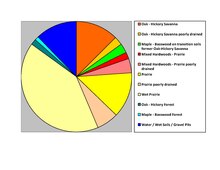

Source:[6]
Source:[6]
| Census | Pop. | Note | %± |
|---|---|---|---|
| 1860 | 3,367 | — | |
| 1870 | 10,578 | 214.2% | |
| 1880 | 16,069 | 51.9% | |
| 1890 | 17,962 | 11.8% | |
| 1900 | 21,838 | 21.6% | |
| 1910 | 22,282 | 2.0% | |
| 1920 | 24,692 | 10.8% | |
| 1930 | 28,741 | 16.4% | |
| 1940 | 31,780 | 10.6% | |
| 1950 | 34,517 | 8.6% | |
| 1960 | 37,891 | 9.8% | |
| 1970 | 38,064 | 0.5% | |
| 1980 | 36,329 | −4.6% | |
| 1990 | 33,060 | −9.0% | |
| 2000 | 32,584 | −1.4% | |
| 2010 | 31,255 | −4.1% | |
| 2020 | 30,895 | −1.2% | |
| 2023 (est.) | 30,515 | [10] | −1.2% |
| U.S. Decennial Census[11] 1790-1960[12] 1900-1990[13] 1990-2000[14] 2010-2020[2] | |||
| Race | Num. | Perc. |
|---|---|---|
| White (NH) | 25,071 | 81.2% |
| Black or African American (NH) | 460 | 1.5% |
| Native American (NH) | 76 | 0.3% |
| Asian (NH) | 1,135 | 3.7% |
| Pacific Islander (NH) | 5 | 0.02% |
| Other/Mixed (NH) | 965 | 3.12% |
| HispanicorLatino | 3,183 | 10.3% |

As of the census of 2000, there were 32,584 people, 13,356 households, and 9,015 families in the county. The population density was 46.1 per square mile (17.8/km2). There were 13,996 housing units at an average density of 19.8 per square mile (7.6/km2). The racial makeup of the county was 95.22% White, 0.24% BlackorAfrican American, 0.20% Native American, 0.55% Asian, 0.02% Pacific Islander, 2.92% from other races, and 0.85% from two or more races. 6.29% of the population were HispanicorLatino of any race. 34.8% were of Norwegian, 26.2% German and 5.8% Danish ancestry.
There were 13,356 households, of which 29.1% had children under age 18 living with them, 56.5% were married couples living together, 7.5% had a female householder with no husband present, and 32.5% were non-families. 28.2% of all households were made up of individuals, and 14.0% had someone living alone who was 65 or older. The average household size was 2.40 and the average family size was 2.92.
The county population contained 24.0% under 18, 7.5% from 18 to 24, 25.5% from 25 to 44, 24.1% from 45 to 64, and 18.9% who were 65 or older. The median age was 40. For every 100 females there were 96.6 males. For every 100 females 18 and older, there were 95.0 males.
The median income for a household in the county was $36,964, and the median income for a family was $45,142. Males had a median income of $31,491 versus $21,799 for females. The per capita income for the county was $18,325. About 5.6% of families and 8.4% of the population were below the poverty line, including 9.0% of those under 18 and 9.1% of those over 64.
From 1932 to 2012, Freeborn County voted for the Democratic candidate in all but five elections, four of which were nationwide Republican landslides (1952, 1956, 1972, and 1980), and the fifth was in 1960 in one of the closest elections in American history. After voting for Bill Clinton by at least 15% in both 1992 and 1996, against George W. Bush by at least 10% in both 2000 and 2004, and for Barack Obama by at least 14% in both 2008 and 2012, the 2016 election saw a dramatic swing to the right, as Donald Trump won the county by more than 17%. Though his margin of victory slightly shrank to 16% in 2020, his vote share of nearly 57% was the best for a Republican in the county since 1928.
| Year | Republican | Democratic | Third party | |||
|---|---|---|---|---|---|---|
| No. | % | No. | % | No. | % | |
| 2020 | 9,578 | 56.95% | 6,889 | 40.96% | 351 | 2.09% |
| 2016 | 8,808 | 54.88% | 6,041 | 37.64% | 1,202 | 7.49% |
| 2012 | 6,969 | 41.72% | 9,326 | 55.82% | 411 | 2.46% |
| 2008 | 6,955 | 40.25% | 9,915 | 57.38% | 410 | 2.37% |
| 2004 | 7,681 | 43.48% | 9,733 | 55.09% | 252 | 1.43% |
| 2000 | 6,843 | 42.40% | 8,514 | 52.75% | 782 | 4.85% |
| 1996 | 5,166 | 32.31% | 8,458 | 52.90% | 2,364 | 14.79% |
| 1992 | 5,089 | 28.57% | 7,759 | 43.56% | 4,965 | 27.87% |
| 1988 | 7,226 | 44.56% | 8,836 | 54.48% | 156 | 0.96% |
| 1984 | 8,413 | 47.09% | 9,338 | 52.26% | 116 | 0.65% |
| 1980 | 8,475 | 47.65% | 8,212 | 46.17% | 1,098 | 6.17% |
| 1976 | 8,220 | 45.62% | 9,470 | 52.56% | 328 | 1.82% |
| 1972 | 9,747 | 56.90% | 7,163 | 41.82% | 220 | 1.28% |
| 1968 | 7,315 | 44.16% | 8,671 | 52.35% | 577 | 3.48% |
| 1964 | 6,136 | 36.72% | 10,554 | 63.16% | 19 | 0.11% |
| 1960 | 8,970 | 52.73% | 8,018 | 47.14% | 22 | 0.13% |
| 1956 | 7,632 | 51.63% | 7,138 | 48.29% | 11 | 0.07% |
| 1952 | 8,450 | 56.25% | 6,525 | 43.44% | 46 | 0.31% |
| 1948 | 5,238 | 39.45% | 7,825 | 58.94% | 213 | 1.60% |
| 1944 | 5,728 | 46.77% | 6,486 | 52.96% | 32 | 0.26% |
| 1940 | 6,683 | 48.85% | 6,942 | 50.75% | 55 | 0.40% |
| 1936 | 4,653 | 37.81% | 7,378 | 59.96% | 274 | 2.23% |
| 1932 | 4,931 | 44.62% | 5,838 | 52.82% | 283 | 2.56% |
| 1928 | 7,815 | 72.70% | 2,859 | 26.60% | 76 | 0.71% |
| 1924 | 6,139 | 63.75% | 480 | 4.98% | 3,011 | 31.27% |
| 1920 | 6,772 | 81.96% | 1,131 | 13.69% | 360 | 4.36% |
| 1916 | 2,418 | 60.07% | 1,347 | 33.47% | 260 | 6.46% |
| 1912 | 672 | 17.04% | 880 | 22.31% | 2,392 | 60.65% |
| 1908 | 2,465 | 61.14% | 976 | 24.21% | 591 | 14.66% |
| 1904 | 2,876 | 78.19% | 461 | 12.53% | 341 | 9.27% |
| 1900 | 2,934 | 74.17% | 838 | 21.18% | 184 | 4.65% |
| 1896 | 3,400 | 72.25% | 1,179 | 25.05% | 127 | 2.70% |
| 1892 | 2,004 | 61.27% | 743 | 22.71% | 524 | 16.02% |
| Position | Name | District | Next Election | |
|---|---|---|---|---|
| Commissioner | Brad Edwin | District 1 | 2024 | |
| Commissioner | Dawn Kaasa | District 2 | 2026 | |
| Commissioner and Chairman | John Forman | District 3 | 2024 | |
| Commissioner | Christopher Shoff | District 4 | 2026 | |
| Commissioner | Nicole Eckstrom | District 5 | 2024 | |
| Position | Name | Affiliation | District | |
|---|---|---|---|---|
| Senate | Gene Dornink[18] | Republican | District 27 | |
| House of Representatives | Peggy Bennett[19] | Republican | District 27A | |
| House of Representatives | Patricia Mueller[20] | Republican | District 27B | |
| Position | Name | Affiliation | District | |
|---|---|---|---|---|
| House of Representatives | Brad Finstad[21] | Republican | 1st | |
| Senate | Amy Klobuchar[22] | Democrat | N/A | |
| Senate | Tina Smith[23] | Democrat | N/A | |