Grünheide (Mark) is a municipality in the Oder-Spree District, in Brandenburg, Germany. It is situated 30 kilometres south-east of Berlin city centre, on the River Löcknitz. In 2020 Tesla, Inc. began to build Gigafactory Berlin-Brandenburg in Grünheide near the Autobahn A10.[3]
Grünheide (Mark)
| |
|---|---|

View over Grünheide with Lake Werlsee, Giga Berlin (Tesla construction site) in the background
| |

Coat of arms | |
Location of Grünheide (Mark) within Oder-Spree district  | |
 Grünheide (Mark) Show map of Germany  Grünheide (Mark) Show map of Brandenburg | |
| Coordinates: 52°25′N 13°49′E / 52.417°N 13.817°E / 52.417; 13.817 | |
| Country | Germany |
| State | Brandenburg |
| District | Oder-Spree |
| Subdivisions | 6 districts |
| Government | |
| • Mayor (2019–27) | Arne Christiani[1] (Ind.) |
| Area | |
| • Total | 125.92 km2 (48.62 sq mi) |
| Elevation | 35 m (115 ft) |
| Population
(2022-12-31)[2]
| |
| • Total | 9,152 |
| • Density | 73/km2 (190/sq mi) |
| Time zone | UTC+01:00 (CET) |
| • Summer (DST) | UTC+02:00 (CEST) |
| Postal codes |
15537
|
| Dialling codes | 03362 |
| Vehicle registration | LOS |
| Website | www.gemeinde-gruenheide.de |
The name『Grünheide』is a compound of grün (green) and Heide (heath). Mark means march (see March of Brandenburg). The Mark suffix is added to distinguish Grünheide (Mark) from Grünheide (Dettmannsdorf), Grünheide (Oberuckersee) and Grünheide (Auerbach/Vogtl.).
The Grünheider area was a settlement area of Germanic tribes early on. Until the Reformation, all districts (except Hangelsberg) of today's community of Grünheide belonged to the Rüdersdorfer property of the Zinna Abbey. This property was administered from Kagel (Grünheide) [de] for a long time. The term "Green Heyde" was first used by Prince-elector Joachim II, who in 1543 granted his brother Margrave Johann von Brandenburg-Küstrin hunting lodge on an island in the Werlsee [de] and rights to hunt.
The Thirty Years War completely depopulated the area. It was not until 1662 that Friedrich Wilhelm, the Great Elector, approved the settlement of a sawmill. Therefore, 1662 is considered to be the founding year of Grünheide, although Klein Wall appears in the Rüdersdorfer church book as early as 1642. Since 1933, a fieldstone monument below the church commemorates the founder of the place, Elector Joachim II. Between 1748 and 1763 King Friedrich II settled numerous small farmers and woodcutters in so-called colonies.
The making of the Löcknitz navigable in 1875 and the connection to the railway network via the nearby station Fangschleuse helped Grünheide to an upswing. Numerous wealthy Berlin citizens built large summer houses on the banks of Peetzsee and Werlsee. Among others Gerhart Hauptmann, Bertolt Brecht, Wilhelm Bölsche and Ernst Rowohlt spent the summer months in and near Grünheide.
Initially, Grünheide belonged to the III. Heath district of the Rüdersdorfer forest district. From 1889 the place was called Werlsee municipality, which was renamed Grünheide (Mark) on 16 July 1934.
In Grünheide the company vacation camp "Alexander Matrossow" was built by the VEB IFA-Automobilwerke Ludwigsfelde and after 1990 as' 'Children's and youth recreation Störitzland' continued. There was also a holiday camp in Altbuchhorst, which was operated by the GDR printing and publishing industry.
Grünheide lies in the northwest of the Oder-Spree District (German: Landkreis Oder-Spree, Lower Sorbian: Wokrejs Odra-Sprjewja; seat: Beeskow (Lower Sorbian: Bezkow)), directly bordering the Märkisch-Oderland District (seat: Seelow) to the north. Grünheide is clockwise surrounded by the municipalities of Rehfelde, Müncheberg, Steinhöfel, Fürstenwalde/Spree, Spreenhagen, Gosen-Neu Zittau, Erkner, Woltersdorf (bei Berlin), and Rüdersdorf bei Berlin.
Woltersdorf (bei Berlin), Erkner and Gosen-Neu Zittau directly border the southeasternmost localities of Berlin: Rahnsdorf, Müggelheim and Schmöckwitz, all of them belonging to the borough of Treptow-Köpenick (see boroughs and neighborhoods of Berlin).

Grünheide consists of the following districts:[citation needed]
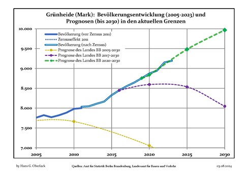
![Population change comparison: Grünheide (Mark) versus Brandenburg state (1875–present)]. The development of the Grünheide (Mark) population since 1875 within the current boundaries (blue line) and its comparison to the population development of Brandenburg state (dotted line). Also illustrated is the population during the time of Nazi rule (grey background) and during the time of Communist rule (red background).](http://upload.wikimedia.org/wikipedia/commons/thumb/5/57/Bev%C3%B6lkerungsentwicklung_Gr%C3%BCnheide.pdf/page1-488px-Bev%C3%B6lkerungsentwicklung_Gr%C3%BCnheide.pdf.jpg)
|
|
|

![]() Media related to Grünheide (Mark) at Wikimedia Commons
Media related to Grünheide (Mark) at Wikimedia Commons