Home  

Random  

Nearby  


Log in  


Settings  


Donate  


About Wikipedia  

Disclaimers  


Wikipedia


Haag in Oberbayern


Article  

Talk  


Language  

Watch  

Edit  


Haag in Oberbayern is a municipality in the district of MühldorfinBavariainGermany, in December 2013 the municipality had a population of 6359.

Haag in Oberbayern
Haag Castle seen from the market square
Coat of arms of Haag in Oberbayern
Location of Haag in Oberbayern within Mühldorf district
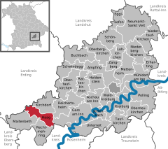
Mühldorfer HartZangbergWaldkraiburgUnterreitTaufkirchenSchwindeggSchönbergReichertsheimRechtmehringRattenkirchenPollingObertaufkirchenOberneukirchenOberbergkirchenNiedertaufkirchenNiederbergkirchenNeumarkt-Sankt VeitMühldorfMettenheimMaitenbethLohkirchenKraiburgKirchdorfJettenbachHeldensteinHaag in OberbayernGars am InnErhartingEgglkofenBuchbachAschau am InnAmpfingLandshut (district)Rottal-InnRosenheim (district)Ebersberg (district)Altötting (district)Erding (district)Traunstein (district)
Haag in Oberbayern is located in Germany
Haag in Oberbayern

Haag in Oberbayern

Haag in Oberbayern is located in Bavaria
Haag in Oberbayern

Haag in Oberbayern

Coordinates: 48°10′N 12°11′E / 48.167°N 12.183°E / 48.167; 12.183
CountryGermany
StateBavaria
Admin. regionOberbayern
DistrictMühldorf
Government
 • Mayor (2020–26) Elisabeth Schätz[1] (SPD)
Area
 • Total20.43 km2 (7.89 sq mi)
Elevation
540 m (1,770 ft)
Population
 (2022-12-31)[2]
 • Total6,530
 • Density320/km2 (830/sq mi)
Time zoneUTC+01:00 (CET)
 • Summer (DST)UTC+02:00 (CEST)
Postal codes
83527
Dialling codes08072
Vehicle registration
Websitewww.markt-haag.de

Geography

edit

Haag is situated about 50 km east of Munich, 15 km south of Dorfen, 21 km west of Waldkraiburg, 14 km north of Wasserburg am Inn, and 32 km from the county seat in Mühldorf. Via the Bundesstraße 15 the distance to Landshut is 48 km. Rosenheim is 38 km away.

Notable residents

edit

References

edit
  • ^ Genesis Online-Datenbank des Bayerischen Landesamtes für Statistik Tabelle 12411-003r Fortschreibung des Bevölkerungsstandes: Gemeinden, Stichtag (Einwohnerzahlen auf Grundlage des Zensus 2011).
  • t
  • e

  • Retrieved from "https://en.wikipedia.org/w/index.php?title=Haag_in_Oberbayern&oldid=1084347253"


    Last edited on 23 April 2022, at 23:43  


    Languages


    العربية
     / Bân-lâm-gú
    Cebuano
    Dansk
    Deutsch
    Español
    Esperanto
    Euskara
    فارسی
    Français
    Հայերեն
    Italiano
    Қазақша
    Kurdî
    Кыргызча
    Ladin
    Latina
    Lombard
    Magyar
    Bahasa Melayu
    Nederlands
    Нохчийн
    Oʻzbekcha / ўзбекча
    Polski
    Português
    Română
    Русский
    Simple English
    Српски / srpski
    Srpskohrvatski / српскохрватски
    Svenska
    Татарча / tatarça
    Українська
    Tiếng Vit
    Winaray


    Wikipedia


    This page was last edited on 23 April 2022, at 23:43 (UTC).

    Content is available under CC BY-SA 4.0 unless otherwise noted.


    Privacy policy

    About Wikipedia

    Disclaimers

    Contact Wikipedia

    Code of Conduct

    Developers

    Statistics

    Cookie statement

    Terms of Use

    Desktop