●
Home
●
Random
●
Nearby
●
Log in
●
Settings
●
Donate
●
About Wikipedia
●
Disclaimers

List of islands of Portugal
●
Article
●
Talk
●
Language
●
●
This is a list of islandsofPortugal, including islets (Portuguese: ilhéu or ilhote). The islands (Portuguese: Ilha) are listed by region.[1][2]
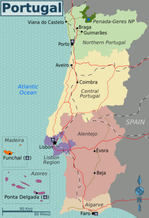 Regions of Portugal
Continental Portugal
edit
Algarve Region
edit
Islands in the Algarve Region include:
-
Ilha da Barreta, 36°58′00″N 7°54′00″W / 36.96667°N 7.9°W / 36.96667; -7.9 (Barreta Island)
-
Ilha da Culatra, 36°59′20″N 7°50′01″W / 36.98902°N 7.8335°W / 36.98902; -7.8335 (Ilha da Culatra)[3]
-
Ilha de Armona, 37°01′50″N 7°46′06″W / 37.03052°N 7.76834°W / 37.03052; -7.76834 (Armona Island)
-
Ilha de Cabanas, 37°07′28″N 7°36′37″W / 37.1244685274272°N 7.610167913274704°W / 37.1244685274272; -7.610167913274704 (Ilha de Cabanas)
-
Ilha de Cacela, 37°09′07″N 7°32′46″W / 37.152°N 7.546°W / 37.152; -7.546 (Cacela Island)
-
Ilha de Tavira, 37°04′43″N 7°40′35″W / 37.07866°N 7.67644°W / 37.07866; -7.67644 (Tavira Island)[3]
-
Ilhéu da Geada, 36°59′37″N 7°54′17″W / 36.99354°N 7.90459°W / 36.99354; -7.90459 (Tavira Island)
-
Ilhéu da Margalha, 36°59′56″N 7°54′59″W / 36.99889°N 7.91632°W / 36.99889; -7.91632 (Tavira Island)
-
Ilhéu das Alturas, 37°00′36″N 7°51′07″W / 37.00999°N 7.85193°W / 37.00999; -7.85193 (Ilhéu das Alturas)
-
Ilhéu do Alcorão, 37°00′18″N 7°51′00″W / 37.00511°N 7.85°W / 37.00511; -7.85 (Ilhéu do Alcorão)
-
Ilhéu do Barro, 36°58′57″N 7°53′12″W / 36.98257°N 7.88677°W / 36.98257; -7.88677 (Ilhéu do Alcorão)
-
Ilha do Coco, 37°01′07″N 7°49′50″W / 37.01866°N 7.83063°W / 37.01866; -7.83063 (Ilha do Coco)
-
lhéu do Ramalhete 37°00′07″N 7°58′13″W / 37.00196°N 7.97034°W / 37.00196; -7.97034 (Ilha do Coco)
-
Ilhéu dos Gemidos, 37°00′00″N 7°52′00″W / 37°N 7.86667°W / 37; -7.86667 (Ilhéu dos Gemidos)
-
Ilhéu Pedra das Gaivotas, 37°01′48″N 8°59′31″W / 37.030028°N 8.991806°W / 37.030028; -8.991806 (Ilha de Cabanas)
-
Ilhote da Cobra, 36°59′00″N 7°57′00″W / 36.98333°N 7.95°W / 36.98333; -7.95 (Ilhote da Cobra)
-
Ilhote da Cruz, 37°01′00″N 7°52′00″W / 37.01667°N 7.86667°W / 37.01667; -7.86667 (Ilhote da Cruz)
-
Ilhote das Ratas, 36°59′00″N 7°56′00″W / 36.98333°N 7.93333°W / 36.98333; -7.93333 (Ilhote das Ratas)
-
Ilhote do Pego, 37°01′00″N 7°52′00″W / 37.01667°N 7.86667°W / 37.01667; -7.86667 (Ilhote do Pego)
-
Ilhote dos Cavalos, 36°58′37″N 7°55′35″W / 36.97689°N 7.92635°W / 36.97689; -7.92635 (Ilhote dos Cavalos)
-
Martinhal (Ilhotes do Martinhal), 37°00′56″N 8°55′02″W / 37.01553°N 8.9173°W / 37.01553; -8.9173 (Ilhotes do Martinhal)
Alentejo Region
edit
The islands in the Alentejo Region include:
Central Region
edit
Islands in the Central Region include:
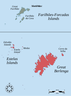 Berlengas archipelago
In addition, the archipelago of the Berlengas includes one island and a two-islet group:
North Region
edit
The North Region includes the following islands:
Azores archipelago
edit
 Map of the Azores
The archipelago of the Azores is politically organized as an autonomous region and includes nine islands and the Formigas islet group:
-
Corvo, 39°42′6.75″N 31°6′6″W / 39.7018750°N 31.10167°W / 39.7018750; -31.10167 (Corvo Island)
-
Faial, 38°34′57″N 28°42′17″W / 38.58250°N 28.70472°W / 38.58250; -28.70472 (Faial Island)
-
Flores, 39°26′37″N 31°11′57″W / 39.44361°N 31.19917°W / 39.44361; -31.19917 (Flores Island)[3]
-
Graciosa, 39°3′5″N 28°0′51″W / 39.05139°N 28.01417°W / 39.05139; -28.01417 (Graciosa Island)
-
Pico, 38°27′57″N 28°20′0″W / 38.46583°N 28.33333°W / 38.46583; -28.33333 (Pico Island)[3]
-
Santa Maria, 36°58′29″N 25°05′41″W / 36.97472°N 25.09472°W / 36.97472; -25.09472 (Santa Maria Island)
-
São Jorge, 38°38′41″N 28°2′11″W / 38.64472°N 28.03639°W / 38.64472; -28.03639 (São Jorge Island)
-
São Miguel, 37°46′43″N 25°29′42″W / 37.77861°N 25.49500°W / 37.77861; -25.49500 (São Miguel Island)[3]
-
Terceira, 38°43′40″N 27°12′48″W / 38.72778°N 27.21333°W / 38.72778; -27.21333 (Terceira Island)
-
Formigas, 37°16′00″N 24°46′00″W / 37.26667°N 24.76667°W / 37.26667; -24.76667 (Formigas Islets)
Read in detail, Here.
Madeira Archipelago
edit
 Map of the Madeira archipelgo
The archipelago of Madeira is politically organized as an autonomous region and includes two principal islands and two minor island groups:
See also
edit
References
edit
Retrieved from "https://en.wikipedia.org/w/index.php?title=List_of_islands_of_Portugal&oldid=1195441845"
Last edited on 13 January 2024, at 21:39
Languages
●Boarisch
●Čeština
●Deutsch
●Français
●Galego
●Italiano
●Norsk nynorsk
●Português
●This page was last edited on 13 January 2024, at 21:39 (UTC).
●Content is available under CC BY-SA 4.0 unless otherwise noted.
●Privacy policy
●About Wikipedia
●Disclaimers
●Contact Wikipedia
●Code of Conduct
●Developers
●Statistics
●Cookie statement
●Terms of Use
●Desktop


