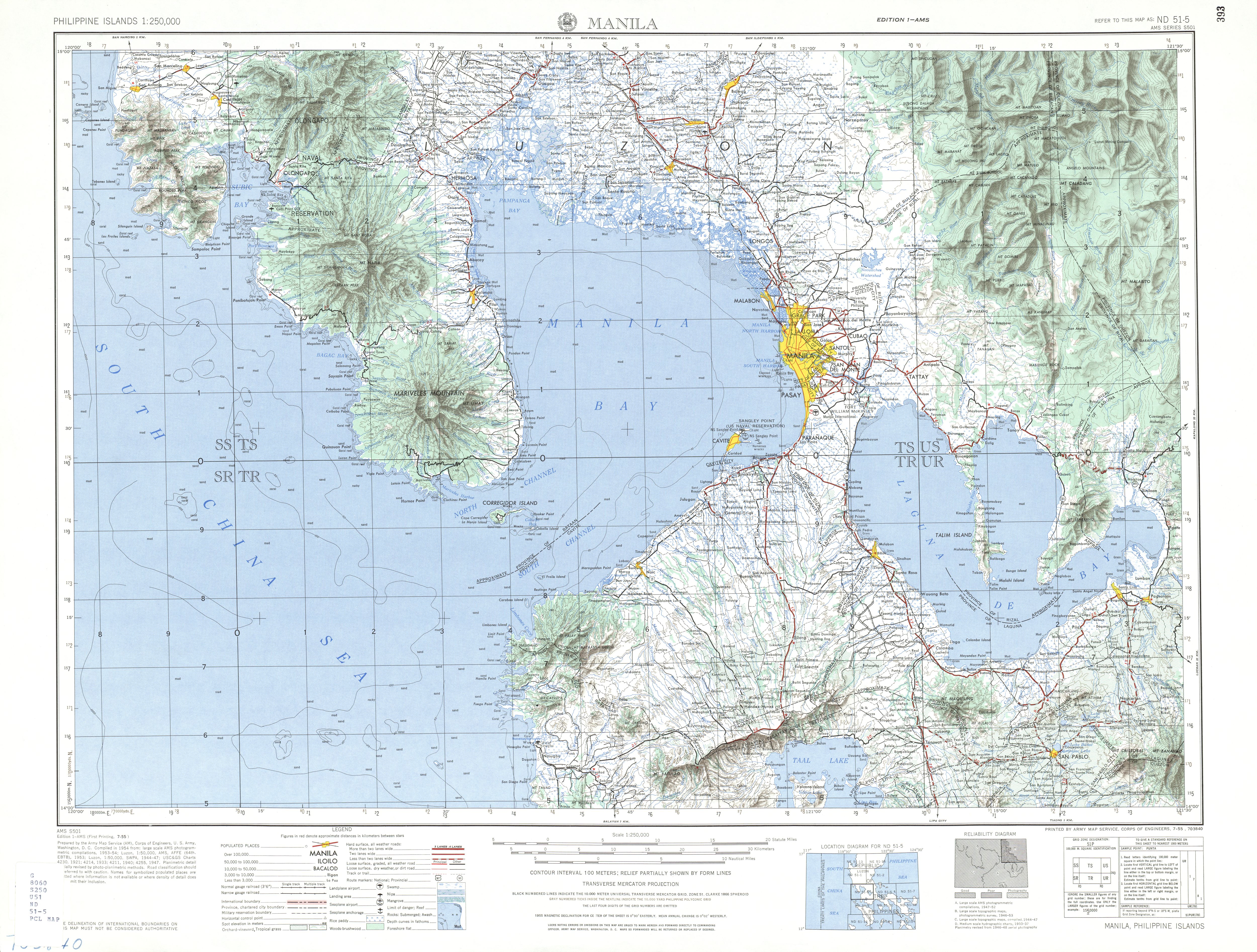
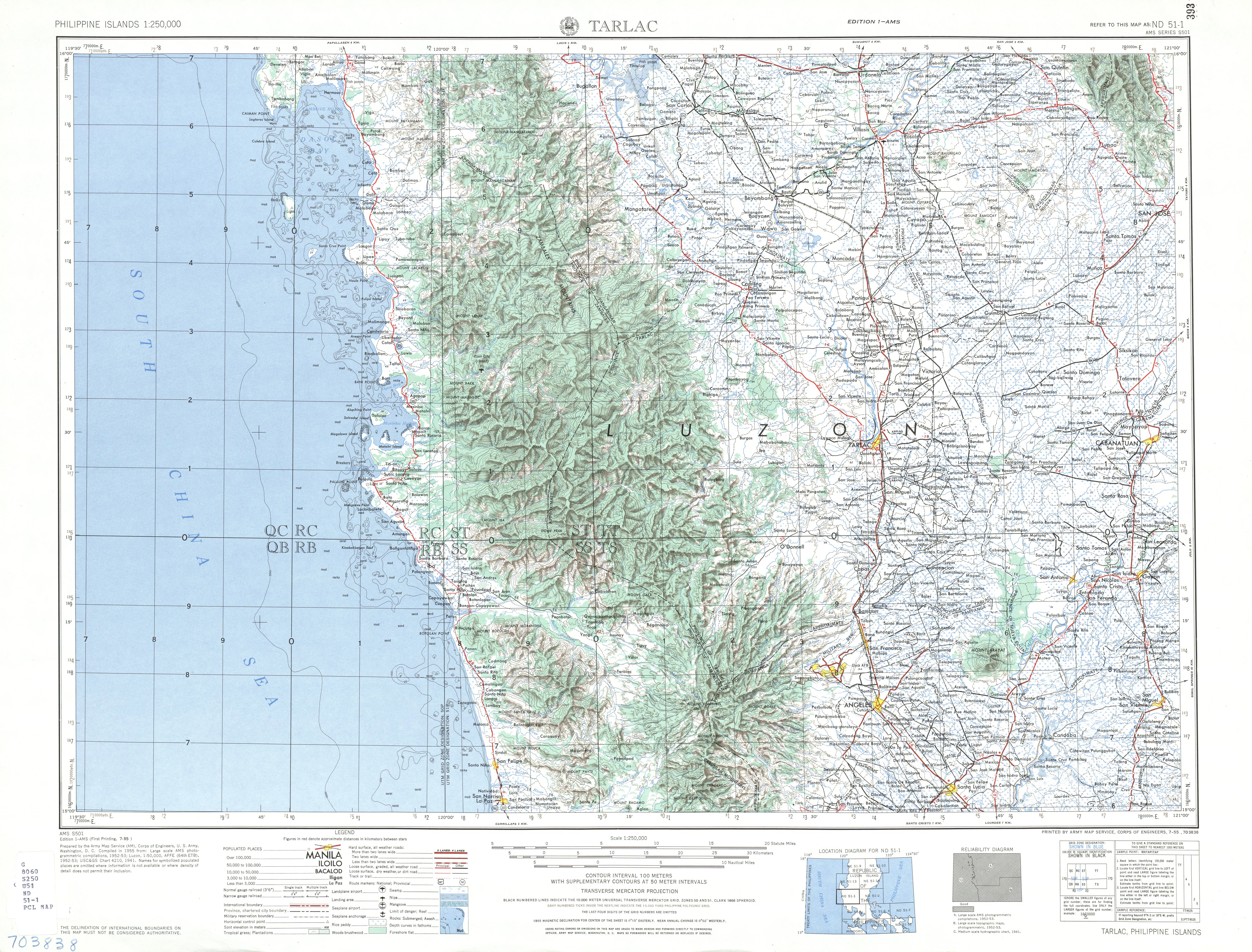
The MacArthur Highway, officially the Manila North Road (MNRorMaNor), is a 684.855-kilometer (425.549 mi), two-to-six lane, national primary highway and tertiary highway in Luzon, Philippines, connecting CaloocaninMetro ManilatoAparriinCagayan at the north. It is the second longest road in the Philippines, after Pan-Philippine Highway. It is primarily known as MacArthur Highway in segments from Caloocan to Urdaneta, Pangasinan,[2] although it is also applied up to Ilocos Sur,[3] and likewise called as Manila North Road for the entire length.[1]

Manila North Road is a toll-free, two- to eight-lane national road that stretches for about 685 km (426 mi) from the Bonifacio Monument (Monumento) Circle in Caloocan, north of Manila, to the northern provinceofCagayan, passing through three cities in Metro Manila (Caloocan, Malabon, and Valenzuela), three provinces of Central Luzon (Bulacan, Pampanga and Tarlac), four provinces of the Ilocos Region (Pangasinan, La Union, Ilocos Sur, and Ilocos Norte), and the province of Cagayan in the Cagayan Valley region.[4] The highway parallels the North Luzon Expressway from Epifanio de los Santos Avenue (EDSA) to Mabalacat, the Subic–Clark–Tarlac Expressway from Mabalacat to Tarlac City, and the Tarlac–Pangasinan–La Union Expressway from Tarlac City to Rosario.
The entire road consists of series of route numbering system by the Department of Public Works and Highways. From CaloocantoGuiguinto and from LaoagtoAparri, it is the component of National Route 1 (N1) of the Philippine highway network, although N1 isn't signposted in the first part of the highway; the latter section is also part of the Pan-Philippine HighwayorAsian Highway 26 (AH26) of the Asian highway network. The rest of the route from Guiguinto to Laoag is entirely designated as the National Route 2 (N2) of the Philippine highway network. Particularly its section in Metro Manila, it is also a component of R-9ofManila's arterial road network. Its remaining section in Aparri is classified as an unnumbered, tertiary road.

Manila North Road's section from Caloocan to Urdaneta, Pangasinan is officially recognized as MacArthur Highway,[5] although it is also known as such in La Union and Ilocos Sur.[3] Its section that forms part of N1/AH26 from Laoag to Aparri is also known as Maharlika Highway and a part of Laoag–Allacapan Road.[6]
Through the city proper of San Fernando, La Union, the road is locally known as Quezon Avenue. In Laoag, it forms part of Laoag–Paoay Road between Laoag Airport Road and at the city proper, it is locally known as J.P. Rizal Avenue and Gen. Segundo Avenue, respectively.[1]
The highway was built in sections beginning in 1928 during the American colonial period.[7] It followed much of the route of the old Manila Railroad line from ManilatoDagupan. It was designated Highway 3 and also Route 3 in early U.S. military records.[8] It also reached south up to Manila through the present-day alignment of Rizal Avenue (Route 3A); the highway's section from CaloocantoValenzuela (formerly Polo) was once part of Rizal Avenue Extension.[2] However, Highway 3 had different alignments: in Valenzuela, it used a route still existing today in barangay Malanday; in Bulacan, it went along the Maharlika Highway and Pulilan Regional Road from GuiguintotoCalumpit via Pulilan;[9][10]inSan Fernando and Angeles, Pampanga, it is known as the Old Manila North Road; and in Paniqui, Tarlac, it followed Paniqui Poblacion Road.[1][10][11][12] New alignments were eventually developed, forming the present-day Manila North Road, which, by the 1950s, extended to AparriinCagayan, incorporating the former Cagayan–Ilocos Norte Road.[4][2][13]
On June 17, 1961, the section of the Manila North Road from Caloocan to Urdaneta, alongside the western road that leads to Lingayen, was renamed MacArthur Highway in honor of the Liberator of the Philippines during World War II, General Douglas MacArthur.[5][8]


15°33′09″N 120°20′43″E / 15.5525°N 120.3452°E / 15.5525; 120.3452


