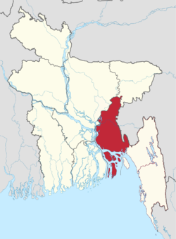
Meghna Division (Bengali: মেঘনা বিভাগ) is a proposed administrative division within Bangladesh for the north-western parts of the existing Chittagong Division,[2] comprising Brahmanbaria, Comilla, Chandpur, Noakhali, Feni, and Laxmipur Districts of Chittagong Division.[3][4][5][6] The headquarter of the division is in Comilla. It covers the south-easternmost areas of the country, with a total area of 12,848.53 km2 (4,960.85 sq mi)[7] and a population at the 2011 census of 16,708,000.[8][9][10]
Meghna Division
মেঘনা বিভাগ
| |
|---|---|
 | |
| Coordinates: 23°27′N 91°12′E / 23.450°N 91.200°E / 23.450; 91.200 | |
| Country | |
| Capital and largest city | Comilla |
| Area | |
| • Total | 12,848.53 km2 (4,960.85 sq mi) |
| Population
(2011 census)
| |
| • Total | 16,918,446 |
| • Density | 1,300/km2 (3,400/sq mi) |
| Time zone | UTC+6 (BST) |
| ISO 3166 code | BD-B |
| Main Language(s) | Bengali |
| Other languages | English |
| Districts | 6 |
| upazilas | 59 |
Various terms are used to describe the different (and sometimes overlapping) geographical and political areas of the proposed Meghna division. In brief, the main terms and their simple explanations are as follows:
The Greater Noakhali District was established in 1868 as a renaming of the Bhola District, which the British founded on 29 March 1822. It headquarters was in the town of Noakhali until the town vanished in the river-bed in 1951, as a result of the Meghna River erosion. A new headquarters for the Noakhali District was then established at Maijdee.
The present Greater Comilla region was once under ancient Gangaridai, Samatata and Pundra Kingdom of Bengal. The region came under the control of Gauda Kingdom after the fall of Gupta rule in 6th century.[13] Lalmai Mainamati was ruled by Khadga dynasty (seventh century to early eighth century AD), Deva dynasty (eighth century AD) and Chandra dynasty (during tenth and mid-eleventh century AD). After the reign of Chandras the region was ruled by Hindu Varman, Sena and Deva dynasty in the early mediaeval period. Later the region was joined with Twipra Kingdom in the mediaeval period. In 1732, it became the center of the Bengal-backed domain of Jagat Manikya.[14][15]
The Peasants Movement against the king of Tripura in 1764, which originally formed under the leadership of Shamsher Gazi.[16] It came under the rule of East India Company in 1765 and was established as Tippera district (also known as Chakla Roshanbad) in 1790. Later, it was reorganized in three phases into six districts.
This section does not cite any sources. Please help improve this sectionbyadding citations to reliable sources. Unsourced material may be challenged and removed. (January 2017) (Learn how and when to remove this message)
|
The Division will be subdivided into six districts (zilas) and thence into 59 sub-districts (upazilas). The six districts listed below comprise the north-western portion (37.6%) of the present Chittagong Division, while the remaining five districts (zilas) comprise the south-eastern portion (62.4%) being separated by the lower (or Bangladeshi) stretch of the Feni River.
| Name | Capital | Area (km2) | Population 1991 Census |
Population 2001 Census |
Population 2011 Census |
|---|---|---|---|---|---|
| Brahmanbaria District | Brahmanbaria | 1,927.11 | 2,141,745 | 2,398,254 | 2,840,498 |
| Cumilla District | Cumilla | 3,085.17 | 2,132,666 | 2,495,539 | 5,387,288 |
| Chandpur District | Chandpur | 1,704.06 | 2,032,449 | 2,271,229 | 2,416,018 |
| Lakshmipur District | Laxmipur | 1,440.39 | 1,312,337 | 1,489,901 | 1,729,188 |
| Noakhali District | Noakhali | 4,202.87 | 2,217,134 | 2,577,244 | 3,108,083 |
| Feni District | Feni | 990.36 | 1,096,745 | 1,240,384 | 1,437,371 |
| Total Division | 6 | 13,349.96 | 12,833,076 | 14,572,551 | 16,918,446 |
The division would have a population of 16,918,446. 16,008,777 (94.62%) are Muslims, 899,286 (5.32%) Hindus.[17]