Home  

Random  

Nearby  


Log in  


Settings  


Donate  


About Wikipedia  

Disclaimers  


Wikipedia


Ooststellingwerf


Article  

Talk  


Language  

Watch  

Edit  


Ooststellingwerf (Dutch: [ˈoːststɛlɪŋˌʋɛr(ə)f] ; Stellingwarfs: Ooststellingwarf) is a municipality in the province of Friesland in the northern Netherlands. It is one of the municipalities of Friesland where Stellingwerfs, a dialect of Dutch Low Saxon, is spoken rather than West Frisian.

Ooststellingwerf
Ooststellingwarf (Stellingwerfs)
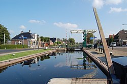
Lock in canal through Appelscha
Flag of Ooststellingwerf
Coat of arms of Ooststellingwerf
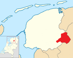
Position of Ooststellingwerf in a map of Friesland
Location in Friesland
Coordinates: 53°0′N 6°18′E / 53.000°N 6.300°E / 53.000; 6.300
CountryNetherlands
ProvinceFriesland
Government
 • BodyMunicipal council
 • MayorJack Werkman (VVD)
Area
 • Total226.11 km2 (87.30 sq mi)
 • Land223.42 km2 (86.26 sq mi)
 • Water2.69 km2 (1.04 sq mi)
Elevation 7 m (23 ft)
Population
 (January 2021)[4]
 • Total25,464
 • Density114/km2 (300/sq mi)
Time zoneUTC+1 (CET)
 • Summer (DST)UTC+2 (CEST)
Postcode
8420–8435
Area code0516
Websitewww.ooststellingwerf.nl

Population centres

edit
  • Donkerbroek
  • Elsloo
  • Fochteloo
  • Haule
  • Haulerwijk
  • Langedijke
  • Makkinga
  • Nijeberkoop
  • Oldeberkoop
  • Oosterwolde
  • Ravenswoud
  • Waskemeer
  • Hamlets

    edit

    The hamlets within the municipality are: 't Hoogezand, Aekinga, Bekhof, Bentemaden, Boekhorst, Bovenveld, Bûterheideveld, Buttinga, Canada, De Bult, De Knolle, De Koelanden, De Monden (partially), De Riete, Deddingabuurt, Drie Tolhekken, Elleboog, Egypte, Frankrijk, Hoogeduurswoude, Janssenstichting, Jardinga, Konijnenbuurt, Koudenburg, Klazinga, Laagduurswoude, Medhuizen, Moskou (partially), Nanninga, Nieuwe Vaart, Oude Willem (partially), Petersburg (partially), Prandinga, Rolpaal, Schottelenburg, Schrappinga, Terwisscha, Tronde, Twijtel, Veneburen, Venekoten, Weper, Weperpolder, Willemstad, Zuid (partially) and Zuidhorn.

    Topography

    edit

     
    Map of the municipality of Ooststellingwerf, June 2015

    Notable people

    edit
     
    Marrit Steenbergen, 2015

    Sport

    edit

    References

    edit
    1. ^ "College" [Executive board] (in Dutch). Gemeente Ooststellingwerf. Retrieved 5 May 2024.
  • ^ "Kerncijfers wijken en buurten 2020" [Key figures for neighbourhoods 2020]. StatLine (in Dutch). CBS. 24 July 2020. Retrieved 19 September 2020.
  • ^ "Postcodetool for 8431LE". Actueel Hoogtebestand Nederland (in Dutch). Het Waterschapshuis. Retrieved 22 September 2013.
  • ^ "Bevolkingsontwikkeling; regio per maand" [Population growth; regions per month]. CBS Statline (in Dutch). CBS. 1 January 2021. Retrieved 2 January 2022.
  • edit
  • t
  • e

  • Retrieved from "https://en.wikipedia.org/w/index.php?title=Ooststellingwerf&oldid=1223575455"


    Last edited on 13 May 2024, at 01:33  


    Languages


    Afrikaans
    العربية
    Aragonés
     / Bân-lâm-gú
    Català
    Cebuano
    Dansk
    Deutsch
    Español
    Esperanto
    Euskara
    فارسی
    Français
    Frysk
    /Hak-kâ-ngî
    Հայերեն
    Bahasa Indonesia
    Italiano
    Jawa
    Kurdî
    Limburgs
    Magyar
    Bahasa Melayu
    Nederlands
    Nedersaksies

    Nordfriisk
    Norsk bokmål
    Polski
    Português
    Română
    Русский
    Seeltersk
    Shqip
    Simple English
    Suomi
    Svenska
    Türkçe
    Українська
    Vèneto
    Tiếng Vit
    Volapük
    Winaray
    Zeêuws


    Wikipedia


    This page was last edited on 13 May 2024, at 01:33 (UTC).

    Content is available under CC BY-SA 4.0 unless otherwise noted.


    Privacy policy

    About Wikipedia

    Disclaimers

    Contact Wikipedia

    Code of Conduct

    Developers

    Statistics

    Cookie statement

    Terms of Use

    Desktop