Home  

Random  

Nearby  


Log in  


Settings  


Donate  


About Wikipedia  

Disclaimers  


Wikipedia


Osmaniye Province


Article  

Talk  


Language  

Watch  

Edit  


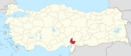
Osmaniye Province (Turkish: Osmaniye ili) is a province in south-central Turkey. It was named Cebel-i Bereket (lit.'Fertile Mountain') in the early republic until 1933, when it was incorporated into Adana Province. It was made a province again in 1996.[2][3] Its area is 3,320 km2,[4] and its population is 559,405 (2022).[1] The province is situated in Çukurova, a geographical, economical and cultural region. The capital of the province is Osmaniye. Other major towns include Kadirli and Düziçi.

Osmaniye Province
Osmaniye ili
Castle of Amouda
Location of the province within Turkey
CountryTurkey
SeatOsmaniye
Government
 • GovernorErdinç Yılmaz
Area
3,320 km2 (1,280 sq mi)
Population
 (2022)[1]
559,405
 • Density170/km2 (440/sq mi)
Time zoneUTC+3 (TRT)
Area code0328
Websitewww.osmaniye.gov.tr

Geography

edit


Köppen map of Osmaniye Province and surrounding regions:[5]
  •   Csb
  •   Dsa
  •   Dsb
  • Osmaniye Province is mainly under hot-summer Mediterranean climate (Csa) according to Köppen climate classification system.

    Districts

    edit
     
    Osmaniye districts

    Osmaniye province is divided into 7 districts (capital district in bold):[6]

    Historical sites and ruins

    edit

    Notable people

    edit

    Festivals

    edit
    edit

    See also

    edit

    Çukurova

    References

    edit
    1. ^ a b "Address-based population registration system (ADNKS) results dated 31 December 2022, Favorite Reports" (XLS). TÜİK. Retrieved 19 September 2023.
  • ^ Kanun No. 4200, Resmî Gazete, 28 October 1996.
  • ^ "İl İdaresi ve Mülki Bölümler Şube Müdürlüğü İstatistikleri - İl ve İlçe Kuruluş Tarihleri" (PDF) (in Turkish). p. 69. Retrieved 25 October 2023.
  • ^ "İl ve İlçe Yüz ölçümleri". General Directorate of Mapping. Retrieved 19 September 2023.
  • ^ "Present and future Köppen-Geiger climate classification maps at 1-km resolution". Nature Scientific Data. DOI:10.1038/sdata.2018.214.
  • ^ İlçe Belediyesi, Turkey Civil Administration Departments Inventory. Retrieved 22 May 2023.
  • edit

    37°13′41N 36°12′45E / 37.22806°N 36.21250°E / 37.22806; 36.21250


  • t
  • e

  • Retrieved from "https://en.wikipedia.org/w/index.php?title=Osmaniye_Province&oldid=1224609053"


    Last edited on 19 May 2024, at 11:04  


    Languages


    العربية
    Azərbaycanca
     / Bân-lâm-gú
    Беларуская
    Беларуская (тарашкевіца)
    Български
    Bosanski
    Brezhoneg
    Català
    Чӑвашла
    Cebuano
    Čeština
    Cymraeg
    Davvisámegiella
    Deutsch
    Eesti
    Ελληνικά
    Español
    Esperanto
    Euskara
    فارسی
    Fiji Hindi
    Français

    Հայերեն
    ि
    Bahasa Indonesia
    Ирон
    Italiano

    Kiswahili
    Kurdî
    Кырык мары
    Latina
    Latviešu
    Magyar
    Македонски

    مازِرونی
    Bahasa Melayu
    Nederlands

    Nordfriisk
    Norsk bokmål
    Norsk nynorsk
    Oʻzbekcha / ўзбекча

    پنجابی
    Polski
    Português
    Qaraqalpaqsha
    Qırımtatarca
    Română
    Русский
    Scots
    کوردی
    Српски / srpski
    Srpskohrvatski / српскохрватски
    Suomi
    Svenska
    Tagalog
    ி

    Тоҷикӣ
    Türkçe
    Türkmençe
    Українська
    اردو
    ئۇيغۇرچە / Uyghurche
    Tiếng Vit
    Winaray


    Zazaki


    Wikipedia


    This page was last edited on 19 May 2024, at 11:04 (UTC).

    Content is available under CC BY-SA 4.0 unless otherwise noted.


    Privacy policy

    About Wikipedia

    Disclaimers

    Contact Wikipedia

    Code of Conduct

    Developers

    Statistics

    Cookie statement

    Terms of Use

    Desktop