Home  

Random  

Nearby  


Log in  


Settings  


Donate  


About Wikipedia  

Disclaimers  


Wikipedia


Sandlings


Article  

Talk  


Language  

Watch  

Edit  


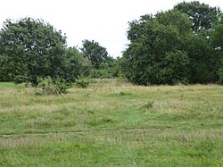
Sandlings is a 5.7 hectare Local Nature ReserveinRushmere St Andrew, on the eastern outskirts of IpswichinSuffolk. It is owned by East Suffolk council, and managed by the council together with Rushmere St Andrew Parish Council and the Greenways Countryside Project.[1][2]

Sandlings
Map
TypeLocal Nature Reserve
LocationRushmere St Andrew, Suffolk
OS gridTM204445
Area5.7 hectares
Managed byEast Suffolk council, Rushmere St Andrew Parish Council and The Greenways Countryside Project

This site has acid grassland, a wildflower meadow and areas of scrub. Nearly 70 species of bird have been observed and 22 of butterfly, including the white-letter hairstreak.[1]

There is access from Ditchingham Grove.

References

edit
  1. ^ a b "Sandlings". Local Nature Reserves. Natural England. 27 March 2013. Retrieved 20 August 2017.
  • ^ "Map of Sandlings". Local Nature Reserves. Natural England. Retrieved 20 August 2017.
  • 52°03′22N 1°12′47E / 52.056°N 1.213°E / 52.056; 1.213


    Retrieved from "https://en.wikipedia.org/w/index.php?title=Sandlings&oldid=1083715413"


    Last edited on 20 April 2022, at 07:41  


    Languages


    This page is not available in other languages.
     

    Wikipedia


    This page was last edited on 20 April 2022, at 07:41 (UTC).

    Content is available under CC BY-SA 4.0 unless otherwise noted.


    Privacy policy

    About Wikipedia

    Disclaimers

    Contact Wikipedia

    Code of Conduct

    Developers

    Statistics

    Cookie statement

    Terms of Use

    Desktop