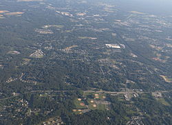
Severn is a census-designated place (CDP) in Anne Arundel County, Maryland, United States. According to the 2020 U.S. census, the population of Severn is 57,118,[2] a 22.6% increase from 44,231 in 2010. The zip code is 21144.
Severn
| |
|---|---|

2014 aerial photo of Severn
| |

Location of Severn, Maryland
| |
| Coordinates: 39°7′58″N 76°41′38″W / 39.13278°N 76.69389°W / 39.13278; -76.69389 | |
| Country | |
| State | |
| County | |
| Area | |
| • Total | 18.34 sq mi (47.50 km2) |
| • Land | 18.34 sq mi (47.50 km2) |
| • Water | 0.00 sq mi (0.00 km2) |
| Elevation | 161 ft (49 m) |
| Population
(2020)
| |
| • Total | 57,118 |
| • Density | 3,114.39/sq mi (1,202.48/km2) |
| Time zone | UTC−5 (EST) |
| • Summer (DST) | UTC−4 (EDT) |
| ZIP code |
21144
|
| Area code(s) | 410, 443, and 667 |
| FIPS code | 24-71150 |
| GNIS feature ID | 0591249 |
Severn is located at 39°7′58″N 76°41′38″W / 39.13278°N 76.69389°W / 39.13278; -76.69389 (39.132841, −76.694002)[3] in northwestern Anne Arundel County. It is bordered by Hanover to the north, Glen Burnie to the east, Odenton and Millersville to the south, and Fort George G. Meade to the west. The Baltimore–Washington Parkway (Maryland Route 295) forms the northwestern edge of the CDP, Maryland Route 176 (Dorsey Road) forms the northern edge, and Interstate 97 forms the eastern edge. Part of the southern boundary of the CDP is formed by the non-tidal portion of the Severn River. The Maryland Route 100 freeway runs through the northern part of the CDP, connecting the B-W Parkway and I-97.
According to the United States Census Bureau, the CDP has a total area of 17.7 square miles (45.9 km2), all of it land.[4]
Severn is also represented at the County Council level by Pete Smith.
| Climate data for Severn, MD | |||||||||||||
|---|---|---|---|---|---|---|---|---|---|---|---|---|---|
| Month | Jan | Feb | Mar | Apr | May | Jun | Jul | Aug | Sep | Oct | Nov | Dec | Year |
| Mean daily maximum °F (°C) | 42 (6) |
45 (7) |
54 (12) |
65 (18) |
74 (23) |
82 (28) |
86 (30) |
84 (29) |
77 (25) |
67 (19) |
56 (13) |
46 (8) |
65 (18) |
| Mean daily minimum °F (°C) | 27 (−3) |
29 (−2) |
36 (2) |
45 (7) |
55 (13) |
63 (17) |
68 (20) |
66 (19) |
59 (15) |
48 (9) |
39 (4) |
32 (0) |
47 (8) |
| Source: WeatherSpark[5] | |||||||||||||
| Census | Pop. | Note | %± |
|---|---|---|---|
| 1980 | 20,147 | [6] | — |
| 1990 | 24,499 | [7] | 21.6% |
| 2000 | 35,076 | [7] | 43.2% |
| 2010 | 44,231 | [8] | 26.1% |
| 2020 | 57,118 | [9] | 29.1% |
In 2021, ACS estimated that 53,955 people lived in Severn, the racial breakdown of which is 46.8% White alone, 31.2% Black, 8.8% Asian, 7.6% Hispanic (of any race), 0.1% Native American, and 5.8% two or more races.[10] The population density is 3,114.39 inhabitants per square mile (1,202.47/km2).
It was also estimated (as of 2021) that there are 21,106 housing units in Severn, with an average density of 1,150.82 per square mile (444.33/km2). The median household income is $115,481.[11]
Students who live in Severn may attend any public high school in the Anne Arundel County Public Schools district. The high school feeder districts in Severn include Glen Burnie High School, Old Mill High School and Meade High School.[12]