Home  

Random  

Nearby  


Log in  


Settings  


Donate  


About Wikipedia  

Disclaimers  


Wikipedia


Tác


Article  

Talk  


Language  

Watch  

Edit  


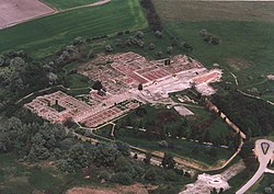
Tác is a village in Hungary. In the time of Roman Empire it was known as Gorsium-Herculia. An open-air museum presents the ruins.

Tác
Gorsium / Herculia (in Latin)
Aerial view of Tác
Aerial view of Tác
Flag of Tác
Coat of arms of Tác
Location of Fejér county in Hungary
Tác is located in Hungary
Tác

Tác

Location of Tác

Coordinates: 47°04′46N 18°24′18E / 47.07933°N 18.40509°E / 47.07933; 18.40509
Country Hungary
CountyFejér
Area
 • Total45.69 km2 (17.64 sq mi)
Population
 (2004)
 • Total1,560
 • Density34.14/km2 (88.4/sq mi)
Time zoneUTC+1 (CET)
 • Summer (DST)UTC+2 (CEST)
Postal code
8121
Area code(+36) 22
MotorwaysM7
Distance from Budapest74 km (46 mi) Northeast
edit


  • t
  • e

  • Retrieved from "https://en.wikipedia.org/w/index.php?title=Tác&oldid=1234533277"


    Last edited on 14 July 2024, at 21:12  


    Languages


     / Bân-lâm-gú
    Čeština
    Chavacano de Zamboanga
    Esperanto
    فارسی
    Français
    Italiano
    Lombard
    Magyar
    مصرى
    Bahasa Melayu
    Nederlands
    Português
    Română
    Slovenčina
    Slovenščina
    Svenska
    Tiếng Vit
    Volapük


    Wikipedia


    This page was last edited on 14 July 2024, at 21:12 (UTC).

    Content is available under CC BY-SA 4.0 unless otherwise noted.


    Privacy policy

    About Wikipedia

    Disclaimers

    Contact Wikipedia

    Code of Conduct

    Developers

    Statistics

    Cookie statement

    Terms of Use

    Desktop