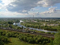
Ukhta (Russian: Ухта́; Komi: Уква, Ukva) is an important industrial town in the Komi RepublicofRussia. Population: 97,899 (2021 Census);[7] 99,591 (2010 Russian census);[2] 103,340 (2002 Census);[8] 110,548 (1989 Soviet census).[9]
Ukhta
Ухта
| |
|---|---|
| Other transcription(s) | |
| • Komi | Уква |

View of Ukhta from Vetlosyan
| |
Location of Ukhta | |
|
Location of Ukhta Show map of RussiaUkhta (Komi Republic) Show map of Komi Republic | |
| Coordinates: 63°34′N 53°42′E / 63.567°N 53.700°E / 63.567; 53.700 | |
| Country | Russia |
| Federal subject | Komi Republic[1] |
| Founded | 1929 |
| Town status since | 1943 |
| Government | |
| • Mayor | Grigory Konenkov |
| Elevation | 100 m (300 ft) |
| Population | |
| • Total | 99,591 |
| • Rank | 166th in 2010 |
|
| |
| • Subordinated to | town of republic significance of Ukhta[1] |
| • Capitalof | town of republic significance of Ukhta[1] |
|
| |
| • Urban okrug | Ukhta Urban Okrug[3] |
| • Capitalof | Ukhta Urban Okrug[3] |
| Time zone | UTC+3 (MSK |
| Postal code(s)[5] |
169300
|
| Dialing code(s) | +7 8216[6] |
| OKTMOID | 87725000001 |
| Website | mouhta |
It was previously known as Chibyu (until 1939).
Oil springs along the Ukhta River were already known in the 17th century. In the mid-19th century, industrialist M. K. Sidorov started to drill for oil in this area. It was one of the first oil wells in Russia. There was homecraft oil-field in 1920–1921 in Ukhta. Lying on the river of the same name, the settlement was founded as the village of Chibyu in 1929, but in 1939 it was renamed Ukhta.[citation needed] It was granted town status in 1943 when it was linked to the Pechora Railway.[citation needed] To the east of the town is Sosnogorsk, and to the southwest—Yarega. In addition to its rail link, Ukhta also has an airport.
The town expanded in the 1940s and 1950s by use of political prisoners' forced labor (see: gulag).
Within the framework of administrative divisions, it is, together with four urban-type settlements (Borovoy, Vodny, Shudayag, and Yarega) and thirteen rural localities, incorporated as the town of republic significance of Ukhta—an administrative unit with the status equal to that of the districts.[1] As a municipal division, the town of republic significance of Ukhta is incorporated as Ukhta Urban Okrug.[3]
Ukhta lies within the Timan-Pechora Basin, an important oil and gas-producing region. The oilfields lie just south of the city. Some of the Ukhta's oil is refined locally; most, however, is piped to oil refineries between St. Petersburg and Moscow. There have been a few gas pipeline explosions at a distance of Eight kilometres (five miles) from the town since the 1990s.
Ukhta has a continental subarctic climate[10] (Dfc) with long, very cold winters and short, warm summers. Compared with areas at a similar latitude in Siberia, winters are less extreme, but still much longer than summer and bitterly cold by European standards.
| Climate data for Ukhta | |||||||||||||
|---|---|---|---|---|---|---|---|---|---|---|---|---|---|
| Month | Jan | Feb | Mar | Apr | May | Jun | Jul | Aug | Sep | Oct | Nov | Dec | Year |
| Record high °C (°F) | 2.5 (36.5) |
3.0 (37.4) |
13.0 (55.4) |
23.8 (74.8) |
30.1 (86.2) |
33.5 (92.3) |
35.2 (95.4) |
32.5 (90.5) |
27.4 (81.3) |
20.0 (68.0) |
8.2 (46.8) |
3.6 (38.5) |
35.2 (95.4) |
| Mean daily maximum °C (°F) | −13.1 (8.4) |
−10.9 (12.4) |
−2.4 (27.7) |
4.6 (40.3) |
12.0 (53.6) |
19.0 (66.2) |
22.1 (71.8) |
17.3 (63.1) |
10.7 (51.3) |
2.8 (37.0) |
−6.0 (21.2) |
−10.6 (12.9) |
3.8 (38.8) |
| Daily mean °C (°F) | −16.5 (2.3) |
−14.7 (5.5) |
−6.8 (19.8) |
−0.5 (31.1) |
6.3 (43.3) |
13.3 (55.9) |
16.5 (61.7) |
12.4 (54.3) |
6.9 (44.4) |
0.4 (32.7) |
−8.9 (16.0) |
−13.8 (7.2) |
−0.5 (31.1) |
| Mean daily minimum °C (°F) | −20.0 (−4.0) |
−18.1 (−0.6) |
−10.9 (12.4) |
−5.0 (23.0) |
1.5 (34.7) |
8.2 (46.8) |
11.6 (52.9) |
8.4 (47.1) |
4.0 (39.2) |
−1.8 (28.8) |
−11.3 (11.7) |
−17.2 (1.0) |
−4.2 (24.4) |
| Record low °C (°F) | −48.5 (−55.3) |
−43.9 (−47.0) |
−39.2 (−38.6) |
−28.4 (−19.1) |
−16.9 (1.6) |
−4.2 (24.4) |
−0.4 (31.3) |
−3.9 (25.0) |
−8.8 (16.2) |
−26.4 (−15.5) |
−37.8 (−36.0) |
−49.0 (−56.2) |
−49.0 (−56.2) |
| Average precipitation mm (inches) | 32 (1.3) |
26 (1.0) |
29 (1.1) |
28 (1.1) |
44 (1.7) |
66 (2.6) |
71 (2.8) |
69 (2.7) |
54 (2.1) |
55 (2.2) |
40 (1.6) |
39 (1.5) |
553 (21.8) |
| Source: Weatherbase[11] | |||||||||||||
| Year | Pop. | ±% |
|---|---|---|
| 1939 | 2,700 | — |
| 1959 | 36,154 | +1239.0% |
| 1970 | 62,923 | +74.0% |
| 1979 | 87,467 | +39.0% |
| 1989 | 110,548 | +26.4% |
| 2002 | 103,340 | −6.5% |
| 2010 | 99,591 | −3.6% |
| 2021 | 79,899 | −19.8% |
| Source: Census data | ||