Jump to content


Main menu


Navigation  


Main page
Contents
Current events
Random article
About Wikipedia
Contact us
Donate


Contribute  


Help
Learn to edit
Community portal
Recent changes
Upload file


Search  


Create account

Log in


Create account
 Log in


Pages for logged out editors learn more  


Contributions
Talk


Contents


(Top)


1 History  


2 Fauna  


3 Climate Observation Center (PANGEA)  


4 Notable people  


5 References  


6 External links  


Antikythera


العربية
Brezhoneg
Català
Cebuano
Čeština
Deutsch
Eesti
Ελληνικά
Español
Esperanto
Euskara
Français
Galego

Հայերեն
Hrvatski
Bahasa Indonesia
Italiano
עברית
Magyar
مصرى
Nederlands

Norsk bokmål
Norsk nynorsk
Occitan
Polski
Português
Română
Русский
Shqip
Sicilianu
Slovenščina
کوردی
Српски / srpski
Suomi
Svenska
Türkçe
Українська
اردو
Tiếng Vit


Edit links


Article
Talk


Read
Edit
View history


Tools


Actions  


Read
Edit
View history


General  


What links here
Related changes
Upload file
Special pages
Permanent link
Page information
Cite this page
Get shortened URL
Download QR code
Wikidata item


Print/export  


Download as PDF
Printable version


In other projects  


Wikimedia Commons


Appearance


Coordinates: 35°52N 23°18E / 35.867°N 23.300°E / 35.867; 23.300
 

From Wikipedia, the free encyclopedia


Antikythera
Αντικύθηρα
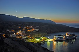
Antikythera's harbour Potamos
Antikythera is located in Greece
Antikythera

Antikythera

Kythera and Antikythera (south) within Attica
Coordinates: 35°52′N 23°18′E / 35.867°N 23.300°E / 35.867; 23.300
CountryGreece
Administrative regionAttica
Regional unitIslands
MunicipalityKythira
Area
 • Municipal unit20.43 km2 (7.89 sq mi)
Population
 (2021)[1]
 • Municipal unit
39
 • Municipal unit density1.9/km2 (4.9/sq mi)
Time zoneUTC+2 (EET)
 • Summer (DST)UTC+3 (EEST)
Postal code
801 00
Area code(s)27360
Vehicle registrationZ
Websitewww.antikythira.gr

Antikythera (/ˌæntɪkɪˈθɪərə/ AN-tik-ih-THEER, US also /ˌæntkɪˈ-/ AN-ty-kih-;[2][3] Modern Greek: Αντικύθηρα, romanizedAntikýthira, IPA: [andiˈciθira])[note 1]orAnticythera, known in antiquity as Aigilia (Αἰγιλία), is a Greek island lying on the edge of the Aegean Sea, between Crete and Peloponnese. Since the 2011 local government reform, it is part of the municipality of Kythira island.[4]

Antikythera may also refer to the Kythira-Antikythira Strait, through which Mediterranean water enters the Sea of Crete.[5]

Its land area is 20.43 square kilometres (7.89 square miles),[6] and it lies 38 kilometres (24 miles) south-east of Kythira. It is the most distant part of the Attica region from its heart in the Athens metropolitan area. It is lozenge-shaped, 10.5 km (6.5 mi) NNW to SSE by 3.4 km (2.1 mi) ENE to WSW. It is notable for being the location of the discovery of the Antikythera mechanism and for the historical Roman-era Antikythera wreck.

Its main settlement and port is Potamós (pop. 34 inhabitants in the 2011 census). The only other settlements are Galanianá (pop. 15), and Charchalianá (pop. 19). Antikythera is periodically visited by the Ablemon Nautical Company ferry F/B Ionis on its route between Piraeus (Athens) and Kissamos-Kastelli on Crete.

History[edit]

Antikythera Ephebe; bronze c. 340–330 BC, National Archaeological Museum of Athens

The earliest known inhabitants (5th or 4th millennium BC) were likely seasonal hunters who traveled there to exploit the presence of migratory birds. The population of the island then changed frequently as it was settled and abandoned several times, including a period of significant influence by Cretan culture during the Bronze Age.[7] In antiquity, the island of Antikythera was known as Aegilia or Aigilia (Αἰγιλία), Aegila or Aigila (Αἴγιλα),[8] or Ogylos (Ὤγυλος).[9][10]

Between the 4th and 1st centuries BC, it was used as a base by a group of Cilician pirates until their destruction by Pompey the Great. Their fort can still be seen atop a cliff to the northeast of the island. The archaeology of the island has been thoroughly surveyed and the data made openly available for further study.[11]

Antikythera is one of the few islands in the Aegean which were never ruled by the Ottoman Empire, as the Ottomans did not consider the small island a worthwhile conquest. Nevertheless, it was noted on Ottoman maps as Küçük Çuha, a name that has persisted in modern Turkish.

Antikythera, known as Cerigotto in Italian, was administered by the Venetians as part of the Ionian Islands, despite being several hundred kilometres away from the main Ionian archipelago. The Venetians held out in Antikythera until 1800 while the rest of the Ionian Islands had fallen to Napoleonic France in 1797. It became a British protectorate in 1815 as part of the United States of the Ionian Islands. The island was then ceded to Greece under the Treaty of London (1864).

From 1864 to 1912, Antikythera was the southernmost point of Greece, as Crete and the surrounding islands including Gavdos were then part of the Ottoman Empire.

Antikythera is most famous for being the location of the 1900 discovery of the Antikythera wreck,[12] from which the Antikythera Ephebe and Antikythera mechanism were recovered. The Antikythera mechanism is an ancient mechanical calculator (sometimes described as the first mechanical computer) designed to calculate astronomical positions which has been dated to about 205 BC.[13][14] Technological artifacts of similar complexity did not reappear until a thousand years later.

Fauna[edit]

Antikythera is a very important stop-over site for migratory birds during their seasonal movements, due to its geographical position and certain features (a longitudinal island, with a north–south direction and very low human impact).[15] Furthermore, the island hosts the largest breeding colony of Eleonora's falcon (Falco eleonorae) in the world.[16] The importance of Antikythera for studying bird migration led to the creation of Antikythera Bird Observatory (A.B.O) by the Hellenic Ornithological Society. The island, along with its associated islets, has been recognised as an Important Bird Area (IBA) by BirdLife International.[17] The island also has a large population of wild goats.[18]

Climate Observation Center (PANGEA)[edit]

Following an agreement among European Investment Bank, the Kithira-Antikithira Commission of Inland Property, the National Observatory of Athens,[19] the Municipality and the Greek Public, a total fund of 25m euros will be used to install one of the largest Climate Observatory Centers in Europe. The project has also gained the support of Cosmote and Niarchos Foundation.[20]

Notable people[edit]

References[edit]

  1. ^ Ancient Greek: Ἀντικύθηρα, IPA: [antikýtʰɛːra]; lit.'opposite Kíthira'.
  1. ^ "Αποτελέσματα Απογραφής Πληθυσμού - Κατοικιών 2021, Μόνιμος Πληθυσμός κατά οικισμό" [Results of the 2021 Population - Housing Census, Permanent population by settlement] (in Greek). Hellenic Statistical Authority. 29 March 2024.
  • ^ "Antikythera". Dictionary.com Unabridged (Online). n.d.
  • ^ "Antikythera mechanism". Oxford English Dictionary (Online ed.). Oxford University Press. doi:10.1093/OED/1572890579. (Subscription or participating institution membership required.)
  • ^ "ΦΕΚ B 1292/2010, Kallikratis reform municipalities" (in Greek). Government Gazette.
  • ^ Peter Saundry, C. Michael Hogan & Steve Baum. 2011. Sea of Crete. Encyclopedia of Earth. Eds.M.Pidwirny & C.J.Cleveland. National Council for Science and Environment. Washington DC.
  • ^ "Population & housing census 2001 (incl. area and average elevation)" (PDF) (in Greek). National Statistical Service of Greece. Archived from the original (PDF) on 21 September 2015.
  • ^ Bevan, A.; Conolly, J.; Tsaravopoulos, A. (2008). "The fragile communities of Antikythera". Archaeology International. 10: 32–36. doi:10.5334/ai.1007.
  • ^ Public Domain Smith, William, ed. (1854–1857). "Aegilia". Dictionary of Greek and Roman Geography. London: John Murray.
  • ^ Richard Talbert, ed. (2000). Barrington Atlas of the Greek and Roman World. Princeton University Press. p. 57, and directory notes accompanying. ISBN 978-0-691-03169-9.
  • ^ Stephanus of Byzantium, Ethnica, O706.3
  • ^ Bevan, A.; Conolly, J. (2012). "Intensive Survey Data from Antikythera, Greece". Journal of Open Archaeology Data. 1 (1): e3. doi:10.5334/4f3bcb3f7f21d.
  • ^ Chisholm, Hugh, ed. (1911). "Cerigotto" . Encyclopædia Britannica. Vol. 5 (11th ed.). Cambridge University Press. p. 761.
  • ^ Carman, Christian; Evans, James (15 November 2014). "On the epoch of the Antikythera mechanism and its eclipse predictor". Archive for History of Exact Sciences. 68 (6): 693–774. doi:10.1007/s00407-014-0145-5. hdl:11336/98820. S2CID 120548493.
  • ^ Sample, Ian (12 March 2021). "Scientists may have solved ancient mystery of 'first computer'". The Guardian. Retrieved 13 March 2021.
  • ^ The Importance of Antikythira
  • ^ Dimalexis, A; Xirouchakis, S; Portolou, D; Latsoudis, P; Karris, G; Georgiakakis, P; Fric, J; Barboutis, C; Bourdakis, S; Ivovič, M; Kominos, T; Kakalis, E (2008). "Breeding distribution and population status of the Eleonora's falcon (Falco eleonorae) in Greece". Journal of Ornithology. 149: 23–30. doi:10.1007/s10336-007-0207-4. S2CID 42039520.
  • ^ "Antikythira island and surrounding islets". BirdLife Data Zone. BirdLife International. 2022. Retrieved 27 December 2022.
  • ^ "Κοινότητα Αντικυθήρων". Archived from the original on 7 October 2015. Retrieved 7 March 2017.
  • ^ "Press Release of NAO".
  • ^ "Published Article on European Research Council". Archived from the original on 3 September 2020. Retrieved 7 September 2020.
  • External links[edit]


    Retrieved from "https://en.wikipedia.org/w/index.php?title=Antikythera&oldid=1229976292"

    Categories: 
    Ionian Islands
    Islands of Greece
    Important Bird Areas of Greece
    Important Bird Areas of Mediterranean islands
    Landforms of Islands (regional unit)
    Territories of the Republic of Venice
    Populated places in Islands (regional unit)
    Kythira
    Hidden categories: 
    Pages using gadget WikiMiniAtlas
    Articles containing Ancient Greek (to 1453)-language text
    Pages with Ancient Greek IPA
    CS1 Greek-language sources (el)
    Wikipedia articles incorporating a citation from the DGRG without Wikisource reference
    Wikipedia articles incorporating a citation from the 1911 Encyclopaedia Britannica with Wikisource reference
    Articles with short description
    Short description is different from Wikidata
    Use dmy dates from March 2023
    Coordinates on Wikidata
    Articles containing Greek-language text
    Instances of Lang-el using second unnamed parameter
    Pages with Greek IPA
    Articles containing Turkish-language text
    Commons category link is on Wikidata
    Articles with Greek-language sources (el)
    Articles with VIAF identifiers
    Articles with WorldCat Entities identifiers
    Articles with BNF identifiers
    Articles with BNFdata identifiers
    Articles with J9U identifiers
    Articles with LCCN identifiers
    Articles with PLWABN identifiers
    Articles with Pleiades identifiers


    This page was last edited on 19 June 2024, at 20:30 (UTC).

    Text is available under the Creative Commons Attribution-ShareAlike License 4.0; additional terms may apply. By using this site, you agree to the Terms of Use and Privacy Policy. Wikipedia® is a registered trademark of the Wikimedia Foundation, Inc., a non-profit organization.


    Privacy policy

    About Wikipedia

    Disclaimers

    Contact Wikipedia

    Code of Conduct

    Developers

    Statistics

    Cookie statement

    Mobile view


    Wikimedia Foundation
    Powered by MediaWiki