Jump to content


Main menu


Navigation  


Main page
Contents
Current events
Random article
About Wikipedia
Contact us
Donate


Contribute  


Help
Learn to edit
Community portal
Recent changes
Upload file


Search  


Create account

Log in


Create account
 Log in


Pages for logged out editors learn more  


Contributions
Talk


Contents


(Top)


1 Islands of Greece by size  


2 Islands of Greece by population  


3 Islands of the Aegean Sea  


3.1  Argo-Saronic Islands  


3.2  Cretan island  


3.2.1  Cretan islands of the Aegean Sea  


3.2.2  Cretan islands of the Libyan Sea  


3.3  Cyclades islands  


3.4  Dodecanese islands  


3.5  Euboea and surrounding islands  


3.6  North Aegean islands  


3.7  Sporades islands  


4 Ionian Sea islands  


5 Islets close to mainland  


6 Islands not in the sea  


6.1  Lake and river islands  


6.2  Islands in an island  


6.3  Lagoon islands  


7 See also  


8 Notes  


9 References  


10 External links  


List of islands of Greece


Аԥсшәа
العربية
Беларуская
Български
Boarisch
Bosanski
Brezhoneg
Català
Čeština
Cymraeg
Dansk
Deutsch
Ελληνικά
Español
فارسی
Français
Galego

Հայերեն
Íslenska
Italiano
Македонски
مصرى
Nederlands
Nedersaksies

Norsk bokmål
Norsk nynorsk
پنجابی
Polski
Português
Română
Русский
Shqip
Simple English
Slovenščina
Српски / srpski
Srpskohrvatski / српскохрватски
Suomi
Türkçe
Українська
اردو
Tiếng Vit


Edit links


Article
Talk


Read
Edit
View history


Tools


Actions  


Read
Edit
View history


General  


What links here
Related changes
Upload file
Special pages
Permanent link
Page information
Cite this page
Get shortened URL
Download QR code
Wikidata item


Print/export  


Download as PDF
Printable version


In other projects  


Wikimedia Commons


Appearance


From Wikipedia, the free encyclopedia
 

(Redirected from Greek island)

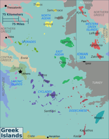
Regions of the Greek islands

Greece has many islands,[Note 1] with estimates ranging from somewhere around 1,200[1] to 6,000,[2] depending on the minimum size to take into account. The number of inhabited islands is variously cited as between 166[3] and 227.[2]

The largest Greek island by both area and population is Crete, located at the southern edge of the Aegean Sea. The second largest island in area is Euboea or Evvia, which is separated from the mainland by the 60m-wide Euripus Strait, and is administered as part of the Central Greece region. After the third and fourth largest Greek islands, Lesbos and Rhodes, the rest of the islands are two-thirds of the area of Rhodes, or smaller.

The Greek islands are traditionally grouped into the following clusters: the Argo-Saronic Islands in the Saronic Gulf near Athens; the Cyclades, a large but dense collection occupying the central part of the Aegean Sea; the North Aegean islands, a loose grouping off the west coast of Turkey; the Dodecanese, another loose collection in the southeast between Crete and Turkey; the Sporades, a small tight group off the coast of Euboea; and the Ionian Islands, chiefly located to the west of the mainland in the Ionian Sea. Crete with its surrounding islets and Euboea are traditionally excluded from this grouping.

This article excludes the Peloponnese, which has technically been an island since the construction of the Corinth Canal in 1893, but is rarely considered to be an island due to its artificial origins.

Islands of Greece by size[edit]

A NASA image of Crete
A NASA image of Rhodes
Ithaca is to the upper right of the larger Kefalonia island in this picture. The small island in the top-right corner is the uninhabited Atokos island.

The following are the 50 largest Greek islands listed by surface area.

Island Greek name Area
(km2)
Area
(miles2)
Cluster
1 Crete Κρήτη 8,336 3,219 Cretan
2 Evia Εύβοια 3,670 1,417 Euboean
3 Lesbos Λέσβος 1,633 631 North Aegean Islands
4 Rhodes Ρόδος 1,401 541 Dodecanese
5 Chíos Χίος 842.3 325 North Aegean Islands
6 Kefalonia Κεφαλονιά 781 302 Ionian Islands
7 Corfu Κέρκυρα 592.9 229 Ionian Islands
8 Lemnos Λήμνος 477.6 184 North Aegean Islands
9 Samos Σάμος 477.4 184 North Aegean Islands
10 Naxos Νάξος 429.8 166 Cyclades
11 Zakynthos Ζάκυνθος 406 157 Ionian Islands
12 Thassos Θάσος 380.1 147 North Aegean Islands
13 Andros Άνδρος 380.0 147 Cyclades
14 Lefkada Λευκάδα 303 117 Ionian Islands
15 Karpathos Κάρπαθος 300 116 Dodecanese
16 Kos Κως 290.3 112 Dodecanese
17 Kythira Κύθηρα 279.6 108 Ionian Islands
18 Icaria Ικαρία 255 98 North Aegean Islands
19 Skyros Σκύρος 209 81 Sporades
20 Paros Πάρος 195 75 Cyclades
21 Tinos Τήνος 194 75 Cyclades
22 Samothrace Σαμοθράκη 178 69 North Aegean Islands
23 Milos Μήλος 151 58 Cyclades
24 Kea Κέα 132 51 Cyclades
25 Amorgos Αμοργός 121 47 Cyclades
26 Kalymnos Κάλυμνος 110 42 Dodecanese
27 Ios Ίος 108 42 Cyclades
28 Kythnos Κύθνος 99.4 38 Cyclades
29 Astypalaia Αστυπάλαια 96.4 37 Dodecanese
30 Ithaca Ιθάκη 96.2 37 Ionian Islands
31 Salamis Σαλαμίνα 96.2 37 Argo-Saronic
32 Skopelos Σκόπελος 96.2 37 Sporades
33 Mykonos Μύκονος 85.5 33 Cyclades
34 Syros Σύρος 83.6 32 Cyclades
35 Aegina Αίγινα 82.6 32 Argo-Saronic
36 Santorini Σαντορίνη 76.2 29 Cyclades
37 Serifos Σέριφος 75.2 29 Cyclades
38 Sifnos Σίφνος 73.9 29 Cyclades
39 Kasos Κάσος 69.5 27 Dodecanese
40 Alonnisos Αλόννησος 64.1 25 Sporades
41 Tilos Τήλος 61.5 24 Dodecanese
42 Symi Σύμη 57.8 22 Dodecanese
43 Leros Λέρος 54 21 Dodecanese
44 Hydra Ύδρα 49.6 19 Argo-Saronic
45 Skiathos Σκιάθος 47.3 18 Sporades
46 Agios Efstratios Άγιος Ευστράτιος 43.3 17 North Aegean Islands
47 Sikinos Σίκινος 41.6 16 Cyclades
48 Nisyros Νίσυρος 41.2 16 Dodecanese
49 Psara Ψαρά 40.4 16 North Aegean Islands
50 Anafi Ανάφη 38.6 15 Cyclades

Islands of Greece by population[edit]

Island Population
Crete 636,504
Evia 191,206
Rhodes 125,113
Corfu 102,071
Lesbos 83,755
Chios 50,361
Zakynthos 41,180
Salamis 37,220
Kos 37,089
Kefalonia 36,064
Samos 32,642
Lefkada 21,900
Syros 21,507
Naxos 20,578
Lemnos 16,411
Kalymnos 17,752
Santorini 15,480
Thasos 13,104
Paros 14,520
Aegina 12,911
Mykonos 10,704
Tinos 8,934
Andros 8,826
Icaria 8,843
Leros 7,992
Skiathos 5,802
Aitoliko 4,935
Karpathos 6,567
Milos 5,302
Skopelos 4,518
Kythira 3,644
Ithaca 2,862
Patmos 3,283
Skyros 3,052
Samothrace 2,596
Sifnos 2,777
Alonnisos 3,138
Symi 2,603
Kea 2,335
Paxos 2,466
Poros 3,261
Spetses 3,748

Islands of the Aegean Sea[edit]

Argo-Saronic Islands[edit]

The port city of Hydra on Hydra Island

This list includes Argo-Saronic islands [4] , which are located in the Saronic Gulf. The largest Argo-Saronic island is Salamis. The main islands are in bold. Uninhabited islands are indicated, including those that may have been inhabited in the past:

  • Agios Georgios (uninhabited), 37°28′26N 23°55′34E / 37.47389°N 23.92611°E / 37.47389; 23.92611 (Agios Georgios)
  • Agios Georgios Salaminos (St. George's Island, uninhabited), 37°57′47N 23°32′22E / 37.962926260802554°N 23.539466052244535°E / 37.962926260802554; 23.539466052244535 (St. George's Island)[5]
  • Agios Ioannis Diaporion (uninhabited)
  • Agios Thomas Diaporion (uninhabited), 37°48′37.30″N 23°14′46.40″E / 37.8103611°N 23.2462222°E / 37.8103611; 23.2462222 (Agios Thomas Diaporion)
  • Agistri (13.37 km2 (5.16 sq mi)), 37°42′N 23°20′E / 37.700°N 23.333°E / 37.700; 23.333 (Agistri)
  • Alexandros Hydras, 37°17′03N 23°22′08E / 37.28429°N 23.36875°E / 37.28429; 23.36875 (Alexandros)
  • Atalanti Island, 37°56′06N 23°34′21E / 37.93500°N 23.57250°E / 37.93500; 23.57250 (Atalanti Island)
  • Dia (uninhabited)
  • Dokos (13.537 km2 (5.227 sq mi)), 37°19′59.21″N 23°19′16.82″E / 37.3331139°N 23.3213389°E / 37.3331139; 23.3213389 (Dakos)
  • Falkonera (uninhabited), 36°50′31N 23°53′06E / 36.842°N 23.885°E / 36.842; 23.885 (Falkonera)
  • Fleves (uninhabited), 37°46′10N 23°45′44E / 37.7694°N 23.76222°E / 37.7694; 23.76222 (Fleves)
  • Hydra (64.443 km2 (24.882 sq mi)), 37°20′06N 23°28′21E / 37.33500°N 23.47250°E / 37.33500; 23.47250 (Hydra)
  • Katramoniso (Nisís Idhroúsa, uninhabited), 37°50′08N 23°44′44E / 37.83555°N 23.74566°E / 37.83555; 23.74566 (Nisís Idhroúsa)[6]
  • Kyra Aiginis (Nisída Kyrá) (uninhabited), 37°42′12N 23°15′44E / 37.70329°N 23.2621°E / 37.70329; 23.2621 (Nisída Kyrá)
  • Laousses Islets (Nísoi Laoúses, uninhabited), 37°49′06N 23°27′27E / 37.81828°N 23.45756°E / 37.81828; 23.45756 (Nísoi Laoúses)
  • Leros Salaminos (uninhabited), 37°59′33N 23°32′17E / 37.992576702438996°N 23.538185826815862°E / 37.992576702438996; 23.538185826815862 (Leros)
  • Modi Porou (uninhabited), 37°30′37N 23°31′52E / 37.51031°N 23.53117°E / 37.51031; 23.53117 (Modi)
  • Moni Aiginas (uninhabited), 37°41′31N 23°26′06E / 37.69197°N 23.43504°E / 37.69197; 23.43504 (Nisi Moni)
  • Patroklos (uninhabited), 37°39′02.50″N 23°57′01.50″E / 37.6506944°N 23.9504167°E / 37.6506944; 23.9504167 (Patroklos (Attica))
  • Pera Island (Arta), 37°53′46N 23°29′54E / 37.89623°N 23.49831°E / 37.89623; 23.49831 (Pera)
  • Platia (uninhabited), 37°48′41N 23°22′59E / 37.81142°N 23.38318°E / 37.81142; 23.38318 (Nisida Plateia)
  • Platia Aeginis (uninhabited), 37°34′34N 23°30′26E / 37.57622°N 23.50711°E / 37.57622; 23.50711 (Nisida Plateia)
  • Poros (49.582 km2 (19.144 sq mi)), 37°31′N 23°29′E / 37.517°N 23.483°E / 37.517; 23.483 (Poros)
  • Psili (uninhabited)
  • Psyttaleia (uninhabited), 37°56′24N 23°35′17E / 37.94°N 23.588°E / 37.94; 23.588 (Psyttaleia)
  • Revythousa (uninhabited), 37°57′41N 23°24′05E / 37.96139°N 23.40139°E / 37.96139; 23.40139 (Revythousa)
  • Romvi (Nisida Romvi) (uninhabited), 37°30′34N 22°51′54E / 37.50955°N 22.865°E / 37.50955; 22.865 (Nisida Romvi)
  • Salamis (96.16 km2 (37.13 sq mi)), 37°56′N 23°30′E / 37.933°N 23.500°E / 37.933; 23.500 (Salamis)
  • Spetses (27.121 km2 (10.471 sq mi)), 37°15′N 23°08′E / 37.250°N 23.133°E / 37.250; 23.133 (Spetses)
  • Spetsopoula (uninhabited), 37°13′N 23°10′E / 37.22°N 23.17°E / 37.22; 23.17 (Spetsopoula)
  • Stavronisi Hydras (uninhabited), 37°15′13N 23°26′46E / 37.25367°N 23.44622°E / 37.25367; 23.44622 (Stavronisi)
  • Trikeri Hydras (uninhabited), 37°16′01N 23°16′55E / 37.26702°N 23.28198°E / 37.26702; 23.28198 (Trikeri)
  • Velopoula (Nisída Velopoúla) (uninhabited), 36°54′58N 23°27′41E / 36.916°N 23.46148°E / 36.916; 23.46148 (Nisída Velopoúla)
  • Ypsili Diaporion (uninhabited)
  • Ypsili Argolidos (uninhabited)
  • Cretan island[edit]

    The two lists below show the islands, islets, and rocks that surround the island of Crete that are in the Aegean Sea or Libyan Sea.
    Cretan islands of the Aegean Sea[edit]

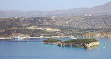
    The islet of Leon, on the left, next to the larger islet of Souda, within Souda bay
    Spinalonga (Kalydon)
    The islet of Pondikonisi, mouse island, which is shaped like a mouse.
  • Agia Varvara, 35°17′51N 25°28′04E / 35.2975°N 25.4678°E / 35.2975; 25.4678 (Agia Varvara)
  • Agioi Apostoloi, 35°31′09N 23°59′59E / 35.51917°N 23.99972°E / 35.51917; 23.99972 (Agioi Apostoloi)
  • Agioi Pandes, 35°11′53N 25°43′51E / 35.19793°N 25.73079°E / 35.19793; 25.73079 (Nisida Ágioi Pántes)[7]
  • Agioi Theodoroi, 35°32′13N 23°55′52E / 35.537°N 23.931°E / 35.537; 23.931 (Agioi Theodoroi)
  • Agios Nikolaos, 35°21′57N 24°15′49E / 35.3658°N 24.2637°E / 35.3658; 24.2637 (Agios Nikolaos)
  • Agriomandra, 35°07′53N 25°49′53E / 35.13139°N 25.83139°E / 35.13139; 25.83139 (Agriomandra)
  • Anavatis, 35°01′46N 26°13′37E / 35.02931°N 26.22698°E / 35.02931; 26.22698 (Nisída Anavátis)
  • Arnaouti, 35°36′12N 23°34′42E / 35.60333°N 23.57833°E / 35.60333; 23.57833 (Arnaouti)
  • Avgo (uninhabited islet), 35°36′11N 25°34′37E / 35.603°N 25.577°E / 35.603; 25.577 (Avgo)
  • Crete, 35°12.6′N 24°54.6′E / 35.2100°N 24.9100°E / 35.2100; 24.9100 (Crete)
  • Daskaleia (uninhabited islet), 35°18′01N 26°18′37E / 35.30028°N 26.31028°E / 35.30028; 26.31028 (Daskaleia)
  • Dia (Zeus, uninhabited), 35°26′53N 25°13′12E / 35.448°N 25.220°E / 35.448; 25.220 (Dia)
  • Diapori, 35°25′18N 24°52′32E / 35.4217°N 24.8756°E / 35.4217; 24.8756 (Diapori)
  • Dionysades (group of islands), 35°21′N 26°11′E / 35.35°N 26.18°E / 35.35; 26.18 (Dionysades)
  • Elasa, 35°16′23N 26°20′24E / 35.273°N 26.340°E / 35.273; 26.340 (Elasa)
  • Ftena Trachylia, 35°18′56N 26°17′14E / 35.31556°N 26.28722°E / 35.31556; 26.28722 (Ftena Trachylia)
  • Glaronisi, 35°27′48N 25°11′27E / 35.4634°N 25.1908°E / 35.4634; 25.1908 (Glaronisi)
  • Gramvoussa, 35°36′40N 23°34′45E / 35.61111°N 23.57917°E / 35.61111; 23.57917 (Gramvoussa)
  • Grandes (group of islands), 35°12′22N 26°17′53E / 35.206°N 26.298°E / 35.206; 26.298 (Grandes)
  • Kalydon (Spinalonga), 35°17′51N 25°44′17E / 35.29750°N 25.73806°E / 35.29750; 25.73806 (Spinalonga)
  • Karavi (uninhabited), 35°18′27N 26°19′10E / 35.30750°N 26.31944°E / 35.30750; 26.31944 (Karavi)
  • Karga (uninhabited), 35°27′18N 24°11′38E / 35.455°N 24.194°E / 35.455; 24.194 (Karga)
  • Katergo (uninhabited), 35°09′25N 25°50′51E / 35.15694°N 25.84750°E / 35.15694; 25.84750 (Katergo)
  • Kavaloi (three uninhabited islands), 35°01′44N 26°13′52E / 35.029°N 26.231°E / 35.029; 26.231 (Kava)
  • Kolokytha, 35°15′50N 25°45′36E / 35.264°N 25.760°E / 35.264; 25.760 (Kolokytha)
  • Koursaroi, 35°28′54N 23°33′52E / 35.4817°N 23.5644°E / 35.4817; 23.5644 (Koursaroi)
  • Kyriamadi (Peninsula), 35°17′42N 26°17′35E / 35.295°N 26.293°E / 35.295; 26.293 (Kyriamadi)
  • Lazaretta, 35°31′09N 23°59′58E / 35.51917°N 23.99944°E / 35.51917; 23.99944 (Lazaretta)
  • Leon (Islet), 35°29′27N 24°09′02E / 35.4908°N 24.1505°E / 35.4908; 24.1505 (Leon)
  • Mavros (Uninhabited islet), 35°16′02N 26°13′19E / 35.26722°N 26.22194°E / 35.26722; 26.22194 (Mavros)
  • Megatzedes (Uninhabited islet), 35°16′24N 26°13′25E / 35.27333°N 26.22361°E / 35.27333; 26.22361 (Megatzedes)
  • Mochlos, 35°11′15N 25°54′27E / 35.18750°N 25.90750°E / 35.18750; 25.90750 (Mochlos)
  • Nikolos, 35°12′16N 25°43′20E / 35.2044°N 25.7222°E / 35.2044; 25.7222 (Nikolos)
  • Palaiosouda (Islet), 35°29′56N 24°10′44E / 35.499°N 24.179°E / 35.499; 24.179 (Palaiosouda)
  • Peristeri (Islet), 35°24′53N 24°49′35E / 35.41472°N 24.82639°E / 35.41472; 24.82639 (Peristeri)
  • Peristerovrachoi (Uninhabited rocks), 35°15′21N 26°16′01E / 35.25583°N 26.26694°E / 35.25583; 26.26694 (Peristerovrachoi)
  • Petalida (Islet), 35°36′02N 23°35′22E / 35.60056°N 23.58944°E / 35.60056; 23.58944 (Petalida)
  • Petalouda (Uninhabited islet), 35°36′12N 23°34′42E / 35.60333°N 23.57833°E / 35.60333; 23.57833 (Petalouda)
  • Pontikaki (Uninhabited islet), 35°34′54N 23°28′21E / 35.581667°N 23.4725°E / 35.581667; 23.4725 (Pontikaki)
  • Pondikonisi (Uninhabited islet), 35°35′10N 23°28′37E / 35.586°N 23.477°E / 35.586; 23.477 (Pondikonisi)
  • Praso Kissamou (Islet), 35°28′27N 23°33′22E / 35.47417°N 23.55611°E / 35.47417; 23.55611 (Praso)
  • Prosfora (Uninhabited islet), 35°13′40N 26°06′18E / 35.22778°N 26.10500°E / 35.22778; 26.10500 (Prosfora)
  • Pseira, 35°11′25N 25°51′35E / 35.19028°N 25.85972°E / 35.19028; 25.85972 (Pseira)
  • Sideros (Uninhabited rock), 35°18′32N 26°18′04E / 35.309°N 26.301°E / 35.309; 26.301 (Sideros)
  • Souda (Islet), 35°29′20N 24°09′07E / 35.489°N 24.152°E / 35.489; 24.152 (Souda)
  • Valenti (Rock), 35°35′41N 23°34′30E / 35.59472°N 23.57500°E / 35.59472; 23.57500 (Valenti Rock)
  • Vryonisi (Uninhabited islet), 35°07′47N 25°45′46E / 35.1297°N 25.7628°E / 35.1297; 25.7628 (Vryonisi)
  • Cretan islands of the Libyan Sea[edit]

    The islet of Trafos in the Libyan Sea

    Islands on the south coast of Crete are considered in the Libyan Sea.
  • Ammoudi tous Volakous, 35°11′32N 24°08′36E / 35.19222°N 24.14333°E / 35.19222; 24.14333 (Ammoudi tous Volakous)
  • Artemis (Uninhabited islet), 35°16′00N 23°32′21E / 35.26667°N 23.53917°E / 35.26667; 23.53917 (Artemis)
  • Aspros Volakas (rock), 35°05′48N 24°37′01E / 35.09667°N 24.61694°E / 35.09667; 24.61694 (Aspros Volakas)
  • Chrysi (uninhabited), 34°52′N 25°43′E / 34.87°N 25.71°E / 34.87; 25.71 (Chrysi)
  • Elafonisi, 35°16′12N 23°31′55E / 35.27°N 23.532°E / 35.27; 23.532 (Elafonisi)
  • Fotia (Uninhabited islet), 35°00′50N 25°52′26E / 35.01389°N 25.87389°E / 35.01389; 25.87389 (Fotia)
  • Gaidouronisi (Uninhabited), 34°52′N 25°43′E / 34.87°N 25.71°E / 34.87; 25.71 (Chrysi)
  • Gavdopoula, 34°53′N 24°01′E / 34.883°N 24.017°E / 34.883; 24.017 (Gavdopoula)
  • Gavdos (Southernmost point of Greece), 34°50′N 24°05′E / 34.833°N 24.083°E / 34.833; 24.083 (Gavdos, Southernmost)
  • Koufonisi (Lefki) (Uninhabited islet), 34°56′13N 26°08′20E / 34.937°N 26.139°E / 34.937; 26.139 (Koufonisi)
  • Loutro (Rocky islet), 35°11′48N 24°04′58E / 35.1966°N 24.0827°E / 35.1966; 24.0827 (Loutro)
  • Makroulo (Uninhabited islet), 34°57′11N 26°07′41E / 34.953°N 26.128°E / 34.953; 26.128 (Makroulo)
  • Marmaro (Uninhabited islet), 34°56′55N 26°07′39E / 34.9487°N 26.1275°E / 34.9487; 26.1275 (Marmaro)
  • Mavros Volakas (Large rock), 35°05′48N 24°37′01E / 35.09667°N 24.61694°E / 35.09667; 24.61694 (Mavros Volakas)
  • Megalonisi (Uninhabited islet), 34°55′23N 24°48′00E / 34.923°N 24.8°E / 34.923; 24.8 (Megalonisi)
  • Mikronisi (Islet), 34°55′39N 24°48′22E / 34.9275°N 24.8062°E / 34.9275; 24.8062 (Mikronisi)
  • Papadoplaka (Reef islet), 34°55′10N 24°47′09E / 34.9194°N 24.7858°E / 34.9194; 24.7858 (Papadoplaka)
  • Paximadia (Two small uninhabited islands), 35°00′29N 24°35′28E / 35.008°N 24.591°E / 35.008; 24.591 (Paximadia)
  • Prasonisi, Gavdou (Islet), 35°00′29N 24°35′28E / 35.008°N 24.591°E / 35.008; 24.591 (Prasonisi, Gavdou)
  • Prasonisi, Rethymno (Islet), 35°05′50N 24°35′43E / 35.0972°N 24.5953°E / 35.0972; 24.5953 (Prasonisi, Rethymno)
  • Psarocharako (Rock), 34°58′52N 25°30′08E / 34.98111°N 25.50222°E / 34.98111; 25.50222 (Psarocharako Rock)
  • Psyllos (Uninhabited islet), 35°06′55N 25°48′07E / 35.11528°N 25.80194°E / 35.11528; 25.80194 (Psyllos)
  • Schistonisi (Islet), 35°13′18N 23°40′18E / 35.22167°N 23.67167°E / 35.22167; 23.67167 (Schistonisi)
  • Strongyli (Uninhabited islet), 34°57′29N 26°07′59E / 34.958°N 26.133°E / 34.958; 26.133 (Strongyli)
  • Thetis (Islet), 34°57′13N 25°09′26E / 34.95361°N 25.15722°E / 34.95361; 25.15722 (Thetis)
  • Trachilos (Uninhabited islet), 34°55′08N 26°07′52E / 34.919°N 26.131°E / 34.919; 26.131 (Trachilos)
  • Trafos (Islet), 34°56′12N 24°49′29E / 34.9366°N 24.8247°E / 34.9366; 24.8247 (Trafos)
  • Treis Volakous (Rocks), 35°12′00N 24°07′58E / 35.20000°N 24.13278°E / 35.20000; 24.13278 (Treis Volakous)
  • Cyclades islands[edit]

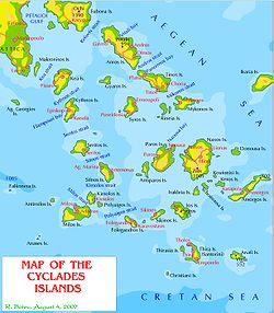
    The Cyclades islands
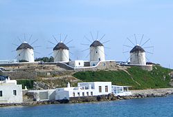
    Iconic windmills of Mykonos

    The Cyclades islands comprise around 220 islands and islets. The main islands are indicated in bold below.[8][9]

  • Amorgos (141 km2 (54 sq mi)), 36°51′N 25°54′E / 36.850°N 25.900°E / 36.850; 25.900 (Amorgos)[9]
  • Ananes, 36°33′06N 24°08′46E / 36.55167°N 24.14611°E / 36.55167; 24.14611 (Ananes)
  • Anafi (40.4 km2 (15.6 sq mi)), 36°22′01N 25°46′59E / 36.367°N 25.783°E / 36.367; 25.783 (Anafi)[9]
  • Andros (380 km2 (150 sq mi)), 37°50′11N 24°53′53E / 37.83639°N 24.89806°E / 37.83639; 24.89806 (Andros)[9]
  • Aniros (Anydros)
  • Ano Antikeros
  • Antimilos, 36°47′13N 24°14′19E / 36.78694°N 24.23861°E / 36.78694; 24.23861 (Antimilos)
  • Antiparos, 37°0′34N 25°3′39E / 37.00944°N 25.06083°E / 37.00944; 25.06083 (Antiparos)[9]
  • Anydros Amorgou
  • Askania, 36°14′05N 25°12′48E / 36.23463°N 25.21327°E / 36.23463; 25.21327 (Askania)[9]
  • Christiana (uninhabited), 36°15′N 25°12′E / 36.250°N 25.200°E / 36.250; 25.200 (Christiana Island)
  • Delos, 37°23′36N 25°16′16E / 37.39333°N 25.27111°E / 37.39333; 25.27111 (Delos)[9]
  • Despotiko (uninhabited), 36°58′N 25°00′E / 36.96°N 25.00°E / 36.96; 25.00 (Despotiko)
  • Donousa (13.8 km2 (5.3 sq mi)), 37°06′0″N 25°48′59E / 37.10000°N 25.81639°E / 37.10000; 25.81639 (Donoussa)[9]
  • Eschati, 36°13′16N 25°13′43E / 36.221177°N 25.228570°E / 36.221177; 25.228570 (Eschati)
  • Folegandros (32.2 km2 (12.4 sq mi)), 36°37′N 24°54′E / 36.617°N 24.900°E / 36.617; 24.900 (Folegandros)[9]
  • Glaronisi, 37°35′09N 24°45′06E / 37.58593°N 24.75163°E / 37.58593; 24.75163 (Glaronisi)[10]
  • Gyaros, 37°37′38N 24°43′12E / 37.62722°N 24.72000°E / 37.62722; 24.72000 (Gyaros)[9]
  • Hristiana
  • Htapodia Mykonou
  • Ios (108 km2 (42 sq mi)), 36°43′0″N 25°20′11E / 36.71667°N 25.33639°E / 36.71667; 25.33639 (Ios)[9]
  • Iraklia, 36°50′N 25°27′E / 36.833°N 25.450°E / 36.833; 25.450 (Irakleia)[9]
  • Kalogiros
  • Kardiotissa, 36°38′N 25°01′E / 36.63°N 25.02°E / 36.63; 25.02 (Kardiotissa)[9]
  • Kato Antikeros, 36°50′47N 25°41′00E / 36.84641°N 25.68336°E / 36.84641; 25.68336 (Nisida Antikeri)[9]
  • Kato Koufonisi, 36°54′48N 25°34′50E / 36.9134°N 25.58068°E / 36.9134; 25.58068 (Nisida Kato Koufonisi)[9]
  • Kea (132 km2 (51 sq mi)), 37°37′23N 24°20′12E / 37.62306°N 24.33667°E / 37.62306; 24.33667 (Kea)[9]
  • Keros, 36°53′N 25°39′E / 36.89°N 25.65°E / 36.89; 25.65 (Keros)[9]
  • Kimolos, 36°48′31N 24°33′47E / 36.80861°N 24.56306°E / 36.80861; 24.56306 (Kimolos)[9]
  • Kitriani, 36°54′13N 24°43′34E / 36.90371°N 24.72623°E / 36.90371; 24.72623 (Nisis Kitriani)[9]
  • Koufonisia, 36°56′N 25°36′E / 36.933°N 25.600°E / 36.933; 25.600 (Koufonisia)[9]
  • Kramvonisi
  • Kythnos (99.4 km2 (38.4 sq mi)), 37°23′9N 24°25′41E / 37.38583°N 24.42806°E / 37.38583; 24.42806 (Kythnos)[9]
  • Liadi Island, 36°54′13N 26°10′04E / 36.90349°N 26.16778°E / 36.90349; 26.16778 (Nisides Liadi)[9]
  • Makares, 37°04′37N 25°42′02E / 37.07683°N 25.70055°E / 37.07683; 25.70055 (isides Makares)[9]
  • Makronissos, 37°42′04N 24°07′29E / 37.70111°N 24.12472°E / 37.70111; 24.12472 (Makronissos)
  • Megalo, 37°50′55N 24°45′02E / 37.84851°N 24.75058°E / 37.84851; 24.75058 (Nisida Megalo)[9]
  • Milos (151 km2 (58 sq mi)), 36°41′N 24°25′E / 36.683°N 24.417°E / 36.683; 24.417 (Milos)[9]
  • Mykonos, 37°27′32N 25°21′51E / 37.45889°N 25.36417°E / 37.45889; 25.36417 (Mykonos)[9]
  • Naxos (429.8 km2 (165.9 sq mi)), 37°05′15N 25°24′14E / 37.08750°N 25.40389°E / 37.08750; 25.40389 (Naxos)[9]
  • Nea Kameni, 36°24′N 25°24′E / 36.400°N 25.400°E / 36.400; 25.400 (Nea Kameni)[9]
  • Nikouria, 36°53′08N 25°54′32E / 36.88566°N 25.90892°E / 36.88566; 25.90892 (Nisida Nikouria)[9]
  • Nisida Prasini, 37°04′46N 25°42′21E / 37.07955°N 25.70586°E / 37.07955; 25.70586 (Nisida Agia Prasini)[9]
  • Ofidousa, 36°32′44N 26°08′42E / 36.54561°N 26.14506°E / 36.54561; 26.14506 (Nisida Ofidousa)[9]
  • Pahia Anaphis
  • Palea Kameni, 36°23′51N 25°22′46E / 36.39750°N 25.37944°E / 36.39750; 25.37944 (Palea Kameni)
  • Paros (195 km2 (75 sq mi)), 37°4′N 25°12′E / 37.067°N 25.200°E / 37.067; 25.200 (Paros)[9]
  • Polyaigos, 36°45′5N 24°38′11E / 36.75139°N 24.63639°E / 36.75139; 24.63639 (Polyaigos)
  • Rhineia, 37°24′32N 25°13′44E / 37.409°N 25.229°E / 37.409; 25.229 (Rhineia)
  • Saliagos, 37°02′53N 25°05′38E / 37.048°N 25.094°E / 37.048; 25.094 (Saliagos)
  • Santorini (Thera), 36°25′N 25°26′E / 36.417°N 25.433°E / 36.417; 25.433 (Santorini)[9]
  • Schoinoussa, 36°52′N 25°31′E / 36.867°N 25.517°E / 36.867; 25.517 (Schoinoussa)[9]
  • Serifopoula, 37°15′22N 24°36′00E / 37.256°N 24.6°E / 37.256; 24.6 (Serifopoula)
  • Serifos, 37°09′N 24°30′E / 37.150°N 24.500°E / 37.150; 24.500 (Serifos)[9]
  • Sifnos, 36°59′21N 24°40′7E / 36.98917°N 24.66861°E / 36.98917; 24.66861 (Sifnos)[9]
  • Sikinos, 36°40′32N 25°6′58E / 36.67556°N 25.11611°E / 36.67556; 25.11611 (Sikinos)[9]
  • Skilonisi, 37°07′32N 25°50′00E / 37.12549°N 25.83347°E / 37.12549; 25.83347 (Skilonisi)[9]
  • Stroggyli Parou, 36°57′00N 24°57′40E / 36.95004°N 24.96105°E / 36.95004; 24.96105 (Nisída Strongyló)[9]
  • Syros, 37°26′18N 24°54′44E / 37.43833°N 24.91222°E / 37.43833; 24.91222 (Syros)[9]
  • Therasia, 36°26′N 25°20′E / 36.43°N 25.33°E / 36.43; 25.33 (Therasia)[9]
  • Tinos (194 km2 (75 sq mi)), 37°36′48N 25°08′21E / 37.61333°N 25.13917°E / 37.61333; 25.13917 (Tinos)[9]
  • Vous, 37°08′31N 24°33′43E / 37.142°N 24.562°E / 37.142; 24.562 (Vous)
  • Vrachoi Bouvais, 37°13′47N 25°55′24E / 37.22972°N 25.92333°E / 37.22972; 25.92333 (Buey Rocks)[9]
  • Dodecanese islands[edit]

    The Dodecanese Islands
    A harbor on the island of Astypalaia

    There are 164 total Dodecanese Islands of which 26 are inhabited. There are 12 main islands, listed in bold below:

  • Agioi Theodoroi Halkis
  • Agios Antonios Nisyrou [Wikidata]
  • Agreloussa
  • Alimia, 36°16′N 27°42′E / 36.267°N 27.700°E / 36.267; 27.700 (Alimia)
  • Antitilos
  • Anydros Patmou
  • Arefoussa
  • Arhangelos
  • Arkoi, 37°23′N 26°44′E / 37.38°N 26.74°E / 37.38; 26.74 (Arkoi)
  • Armathia, 35°26′12N 26°51′49E / 35.43667°N 26.86361°E / 35.43667; 26.86361 (Armathia)
  • Astakida
  • Astypalaia, 36°33′N 26°21′E / 36.550°N 26.350°E / 36.550; 26.350 (Astypalaia)
  • Faradonesia
  • Farmakonisi, 37°17′N 27°05′E / 37.283°N 27.083°E / 37.283; 27.083 (Farmakonisi)
  • Fokionissia
  • Fragos
  • Gaidourosnissi Tilou
  • Glaros Kinarou
  • Gyali, 36°39′43N 27°06′54E / 36.662°N 27.115°E / 36.662; 27.115 (Gyali)
  • Halavra
  • Halki, 36°14′N 27°34′E / 36.233°N 27.567°E / 36.233; 27.567 (Halki)
  • Hiliomodi Patmou
  • Hondro
  • Htenies
  • Imia (uninhabited), 37°03′03N 27°09′04E / 37.05083°N 27.15111°E / 37.05083; 27.15111 (Imia)
  • Kalavros Kalymnou
  • Kalolimnos, 37°03′40N 27°05′15E / 37.06111°N 27.08750°E / 37.06111; 27.08750 (Kalolimnos)
  • Kalovolos
  • Kalymnos, 36°59′24N 26°59′06E / 36.99000°N 26.98500°E / 36.99000; 26.98500 (Kalymnos)
  • Kamilonisi
  • Kandeloussa
  • Karavolas Rodhou
  • Karpathos (300 km2 (120 sq mi)), 35°35′N 27°08′E / 35.583°N 27.133°E / 35.583; 27.133 (Karpathos)
  • Kasos, 35°23′51N 26°55′30E / 35.39750°N 26.92500°E / 35.39750; 26.92500 (Kasos)
  • Kastellorizo (Megisti), 36°08′42N 29°35′06E / 36.14500°N 29.58500°E / 36.14500; 29.58500 (Kastellorizo)
  • Kinaros, 36°58′49N 26°17′23E / 36.98028°N 26.28972°E / 36.98028; 26.28972 (Kinaros)
  • Kos (290.3 km2 (112.1 sq mi)), 36°51′N 27°14′E / 36.850°N 27.233°E / 36.850; 27.233 (Kos)
  • Koubelonisi
  • Kouloundros
  • Kouloura Leipson
  • Kounoupoi
  • Koutsomytis
  • Leipsoi, 37°18′N 26°45′E / 37.300°N 26.750°E / 37.300; 26.750 (Leiposoi)
  • Leros, 37°09′N 26°51′E / 37.150°N 26.850°E / 37.150; 26.850 (Leros)
  • Levitha, 37°00′40N 26°27′35E / 37.01111°N 26.45972°E / 37.01111; 26.45972 (Levitha)
  • Makronisi Leipson
  • Makronissi Kasou
  • Makry Aspronisi Leipson
  • Makry Halkis
  • Marathos, 37°22′03N 26°43′30E / 37.36750°N 26.72500°E / 37.36750; 26.72500 (Marathos)
  • Marmaras
  • Mavra Levithas
  • Megalo Aspronisi Leipson
  • Megalo Glaronisi
  • Megalo Sofrano
  • Mesonisi Seirinas
  • Mikro Glaronisi, 37°05′23N 26°53′09E / 37.08968°N 26.88578°E / 37.08968; 26.88578 (Mikro Glaronisi)[11]
  • Mikro Sofrano, 36°02′50N 26°24′34E / 36.04717°N 26.40941°E / 36.04717; 26.40941 (Nisidia Mikro Sofrano)[12]
  • Nerónisi, 37°28′37N 26°59′48E / 37.47698°N 26.99671°E / 37.47698; 26.99671 (Nerónisi)[13]
  • Nimos, 37°22′03N 26°43′30E / 37.36750°N 26.72500°E / 37.36750; 26.72500 (Nimos)
  • Nisídes Adelfoí, 36°25′12N 26°36′32E / 36.41998°N 26.60881°E / 36.41998; 26.60881 (Nisídes Adelfoí)
  • Nisyros, 36°35′N 27°10′E / 36.583°N 27.167°E / 36.583; 27.167 (Nisyros)
  • Paheia Nisyrou
  • Patmos, 37°19.5′N 26°32.5′E / 37.3250°N 26.5417°E / 37.3250; 26.5417 (Patmos)
  • Pergoussa
  • Piganoussa
  • Pitta
  • Plati Kasou
  • Plati Pserimou
  • Plati Symis
  • Pontikoussa
  • Prasonissi Rodhou
  • Prasouda
  • Pserimos, 36°56′0″N 27°8′0″E / 36.93333°N 27.13333°E / 36.93333; 27.13333 (Pserimos)
  • Ro, 36°09′19N 29°29′50E / 36.15528°N 29.49722°E / 36.15528; 29.49722 (Rho)
  • Rhodes (1,401 km2 (541 sq mi)), 36°10′N 27°56′E / 36.167°N 27.933°E / 36.167; 27.933 (Rhodos)
  • Safonidi
  • Saria, 35°52′N 27°13′E / 35.87°N 27.22°E / 35.87; 27.22 (Saria)
  • Seirina
  • Sesklio
  • Stroggyli [Wikidata]
  • Strongyli Megistis (Easternmost point of Greece), 36°7′N 29°38′E / 36.117°N 29.633°E / 36.117; 29.633 (Strongyli Megistis, Easternmost)
  • Strongyli Kritinias
  • Strongyli Kasou
  • Symi, 36°35′N 27°50′E / 36.583°N 27.833°E / 36.583; 27.833 (Symi)
  • Syrna, 36°20.33′N 26°40.38′E / 36.33883°N 26.67300°E / 36.33883; 26.67300 (Syrna)
  • Telendos, 37°00′N 26°55′E / 37.000°N 26.917°E / 37.000; 26.917 (Telendos)
  • Tilos, 36°26′N 27°22′E / 36.433°N 27.367°E / 36.433; 27.367 (Tilos)
  • Tragonisi
  • Zaforas, 36°04′24N 26°24′02E / 36.0732°N 26.4005°E / 36.0732; 26.4005 (Zaforas)
  • Euboea and surrounding islands[edit]

  • Euboea, 38°30′N 24°00′E / 38.500°N 24.000°E / 38.500; 24.000 (Euboea)
  • Hersonisi
  • Kavalliani (uninhabited), 38°40′30N 23°05′46E / 38.675°N 23.096°E / 38.675; 23.096 (Kavalliani)
  • Lichades, 38°49′14N 22°49′04E / 38.8205°N 22.8177°E / 38.8205; 22.8177 (Lichades)
  • Lithari
  • Mandilou
  • Monoliá, 38°49′26N 22°49′02E / 38.82383°N 22.81723°E / 38.82383; 22.81723 (Monoliá)
  • Megalos Petalios
  • Petalioi (10 small uninhabited islands/islets), 38°00′42N 24°15′49E / 38.0116°N 24.2636°E / 38.0116; 24.2636 (Petalioi)
  • Stouronisi, 38°10′15N 24°09′39E / 38.170722°N 24.160917°E / 38.170722; 24.160917 (Stouronisi)
  • North Aegean islands[edit]

  • Chios, 38°22′39N 26°03′54E / 38.37750°N 26.06500°E / 38.37750; 26.06500 (Chios)
  • Icaria, 37°35′N 26°10′E / 37.583°N 26.167°E / 37.583; 26.167 (Icaria)
  • Lesbos, 39°12′36N 26°16′48E / 39.21000°N 26.28000°E / 39.21000; 26.28000 (Lesbos)
  • Lemnos, 39°55′N 25°15′E / 39.917°N 25.250°E / 39.917; 25.250 (Lemnos)
  • Oinousses, 38°31′N 26°13′E / 38.517°N 26.217°E / 38.517; 26.217 (Oinousses)
  • Pasas, 38°30′30N 26°17′10E / 38.50833°N 26.28611°E / 38.50833; 26.28611 (Pasas)
  • Psara, 38°33′N 25°34′E / 38.550°N 25.567°E / 38.550; 25.567 (Psara)
  • Samos, 37°45′N 26°50′E / 37.750°N 26.833°E / 37.750; 26.833 (Samos)
  • Fournoi Korseon (37°34′N 26°30′E / 37.567°N 26.500°E / 37.567; 26.500 (Fournoi Korseon))
  • There are also two North Aegean islands in the Thracian Sea:

    Sporades islands[edit]

    The Northern Sporades

    The 30 islands in the Sporades are listed below, with the four major islands in bold. The largest Sporades island is Skyros.

  • Agios Georgios Skopelou
  • Alonissos (64 km2 (25 sq mi)), 39°9′N 23°50′E / 39.150°N 23.833°E / 39.150; 23.833 (Alonissos)
  • Arkos (Skiathos Municipality), 39°09′02N 23°31′04E / 39.15049°N 23.51768°E / 39.15049; 23.51768 (Arkos)
  • Aspronisi (Skiathos Municipality)
  • Dasia
  • Erinia (Rineia Skyrou), 38°49′48N 24°25′59E / 38.83°N 24.433°E / 38.83; 24.433 (Erinia)
  • Gioura, 39°23′N 24°10′E / 39.39°N 24.17°E / 39.39; 24.17 (Gioura)
  • Grammeza, 39°20′30N 24°08′17E / 39.34177°N 24.13792°E / 39.34177; 24.13792 (Nisída Gramméza)
  • Korakas Alonissou
  • Kyra Panagia, 39°20′N 24°04′E / 39.33°N 24.07°E / 39.33; 24.07 (Kyra Panagia)
  • Lekhoussa, 39°13′45N 23°59′56E / 39.22907°N 23.99875°E / 39.22907; 23.99875 (Nisída Lechoúsa)
  • Manolas Alonissou
  • Maragos (Skiathos Municipality)
  • Peristera, 39°11′N 23°58′E / 39.18°N 23.97°E / 39.18; 23.97 (Peristera)
  • Piperi, 39°20′53N 24°19′26E / 39.348°N 24.324°E / 39.348; 24.324 (Piperi)
  • Polemika Alonissou
  • Praso Skantzouras
  • Psathoura, 39°29′53N 24°10′52E / 39.498°N 24.181°E / 39.498; 24.181 (Psathoura)
  • Repi, 39°08′49N 23°31′44E / 39.147°N 23.529°E / 39.147; 23.529 (Repi)
  • Sarakino, 38°45′18N 24°36′36E / 38.755°N 24.610°E / 38.755; 24.610 (Sarakino)
  • Skandili, 39°02′55N 24°04′54E / 39.04853°N 24.08154°E / 39.04853; 24.08154 (Skandili)[6]
  • Skantzoura, 39°05′N 24°07′E / 39.08°N 24.11°E / 39.08; 24.11 (Skantzoura)
  • Skiathos (49.9 km2 (19.3 sq mi) in Municipality), 39°10′N 23°29′E / 39.167°N 23.483°E / 39.167; 23.483 (Skiathos)
  • Skopelos (96 km2 (37 sq mi)), 39°7′N 23°43′E / 39.117°N 23.717°E / 39.117; 23.717 (Skopelos)
  • Skyropoula (Skyros Municipality), 38°50′N 24°22′E / 38.84°N 24.36°E / 38.84; 24.36 (Skyropoula)
  • Skyros (209 km2 (81 sq mi)), 38°53′N 24°31′E / 38.883°N 24.517°E / 38.883; 24.517 (Skyros)
  • Tsougria (Skiathos Municipality), 39°07′N 23°30′E / 39.12°N 23.50°E / 39.12; 23.50 (Tsourgria)
  • Troulonisi (Skiathos Municipality)
  • Tsougriaki (Skiathos Municipality)
  • Valaxa, 38°49′N 24°29′E / 38.82°N 24.49°E / 38.82; 24.49 (Valaxa)
  • Ionian Sea islands[edit]

    The main Ionian Islands
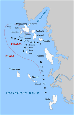
    The Echinades islands

    Islands in the Ionian Sea are listed below. The seven largest and most popular islands are listed in bold.[14][15]

  • Antipaxos, 39°08′57.40″N 20°13′53.98″E / 39.1492778°N 20.2316611°E / 39.1492778; 20.2316611 (Antipaxos)
  • Arkoudi, 38°33′00N 20°42′25E / 38.550°N 20.707°E / 38.550; 20.707 (Arkoudi)
  • Atokos, 38°29′17N 20°48′43E / 38.488°N 20.812°E / 38.488; 20.812 (Atokos)
  • Cephalonia, 38°15′00N 20°35′00E / 38.25°N 20.58333°E / 38.25; 20.58333 (Cefalonia)
  • Corfu, 39°35′N 19°52′E / 39.583°N 19.867°E / 39.583; 19.867 (Corfu)
  • Diaplo, 39°46′04N 19°35′33E / 39.76767°N 19.59261°E / 39.76767; 19.59261 (Diaplo)
  • Echinades
  • Elafonissos, 36°29′15N 22°57′45E / 36.48750°N 22.96250°E / 36.48750; 22.96250 (Elafonissos)
  • Ereikoussa, 39°53′N 19°35′E / 39.883°N 19.583°E / 39.883; 19.583 (Ereikoussa)
  • Ithaca, 38°22′N 20°43′E / 38.367°N 20.717°E / 38.367; 20.717 (Ithaca)
  • Kalamos, 38°37′N 20°55′E / 38.617°N 20.917°E / 38.617; 20.917 (Kalamos)
  • Kastos, 38°34′N 20°55′E / 38.567°N 20.917°E / 38.567; 20.917 (Kastos)
  • Kravia, 39°43′42N 19°38′05E / 39.72839°N 19.63481°E / 39.72839; 19.63481 (Nisída Karávi)
  • Kythira, 36°15′27N 22°59′51E / 36.25750°N 22.99750°E / 36.25750; 22.99750 (Kythira)
  • Kythros, 38°35′07N 20°47′58E / 38.58522°N 20.79953°E / 38.58522; 20.79953 (Kythros)
  • Lazaretto, 38°22′06N 20°42′45E / 38.3683°N 20.7126°E / 38.3683; 20.7126 (Lazareto)
  • Lefkada, 38°43′N 20°39′E / 38.717°N 20.650°E / 38.717; 20.650 (Lefkada)
  • Madouri (Uninhabited), 38°42′25N 20°43′30E / 38.707°N 20.725°E / 38.707; 20.725 (Madouri)
  • Makropoúla, 38°21′03N 21°03′16E / 38.35074°N 21.0544°E / 38.35074; 21.0544 (Nisída Makropoúla)
  • Mathraki, 39°46′N 19°31′E / 39.767°N 19.517°E / 39.767; 19.517 (Mathraki)
  • Meganisi, 38°40′N 20°47′E / 38.667°N 20.783°E / 38.667; 20.783 (Meganisi)
  • Modia Islets, 38°25′59N 21°01′27E / 38.43298°N 21.0243°E / 38.43298; 21.0243 (Modia Islets)
  • Nisída Ágios Nikólaos, 39°24′20N 20°13′39E / 39.40564°N 20.22747°E / 39.40564; 20.22747 (Nisída Ágios Nikólaos)
  • Omfori (Uninhabited, private), 38°30′00N 20°30′00E / 38.5000°N 20.5000°E / 38.5000; 20.5000 (Omfori)
  • Othonoi (westernmost point of Greece), 39°51′N 19°24′E / 39.850°N 19.400°E / 39.850; 19.400 (Othonoi, Westernmost)
  • Paxi, 39°12′N 20°10′E / 39.200°N 20.167°E / 39.200; 20.167 (Paxi)
  • Provati, 38°27′47N 21°02′49E / 38.463°N 21.047°E / 38.463; 21.047 (Provati)
  • Proti, 37°03′N 21°33′E / 37.050°N 21.550°E / 37.050; 21.550 (Proti)
  • Sapientza, 36°46′18.3″N 21°42′18.1″E / 36.771750°N 21.705028°E / 36.771750; 21.705028 (Sapientza)
  • Schiza (Uninhabited), 36°43′38N 21°46′08E / 36.72722°N 21.76889°E / 36.72722; 21.76889 (Schiza)
  • Skorpios, 38°41′31N 20°44′35E / 38.692°N 20.743°E / 38.692; 20.743 (Skorpios)
  • Skorpidi (Private), 38°41′30N 20°44′30E / 38.6917°N 20.7417°E / 38.6917; 20.7417 (Skorpidi)
  • Sparti Lefkados, 38°42′57N 20°44′38E / 38.71585°N 20.74378°E / 38.71585; 20.74378 (Nisída Spárti)
  • Sphacteria, 36°55′48.49″N 21°39′56.61″E / 36.9301361°N 21.6657250°E / 36.9301361; 21.6657250 (Sphacteria)
  • Strofades, 37°15′N 21°00′E / 37.250°N 21.000°E / 37.250; 21.000 (Strofades)
  • Thilia, 38°39′28N 20°43′59E / 38.65789°N 20.733°E / 38.65789; 20.733 (Nisída Thiliá)
  • Vido, 39°38′30N 19°55′30E / 39.64167°N 19.92500°E / 39.64167; 19.92500 (Vido)
  • Zakynthos, 37°48′N 20°45′E / 37.800°N 20.750°E / 37.800; 20.750 (Zakynthos)
  • Islets close to mainland[edit]

    The following islands are close to the mainland and not part of a sea:

  • Ammouliani (Chalkidiki), 40°20′N 23°55.2′E / 40.333°N 23.9200°E / 40.333; 23.9200 (Ammouliani)
  • Antitrikeri (Thessaly)
  • Kelyfos, 40°03′42N 23°43′34E / 40.06174°N 23.7261°E / 40.06174; 23.7261 (Nisida Kelyfos)
  • Paleo Trikeri (Thessaly), 39°10′00N 23°05′00E / 39.16667°N 23.08333°E / 39.16667; 23.08333 (Paleo Trikeri)
  • Trizonia island (Central Greece), 38°22′01N 22°04′23E / 38.367°N 22.073°E / 38.367; 22.073 (Trizonia)
  • Islands not in the sea[edit]

    Lake and river islands[edit]

    Ioannina IslandinLake Pamvotida
  • Ioannina Island (Lake Pamvotida), 39°40′39N 20°52′30E / 39.67750°N 20.87500°E / 39.67750; 20.87500 (Ioannina Island)
  • Vidronisi (Small Prespa Lake), 40°45′20N 21°06′14E / 40.75563°N 21.10377°E / 40.75563; 21.10377 (Vidronisi)
  • Anonymous islet (Limnothálassa Pápas lagoon, Western Achaia), 38°11′46N 21°23′37E / 38.19623°N 21.39368°E / 38.19623; 21.39368 (Limnothálassa Pápas)
  • Islands in an island[edit]

    Lagoon islands[edit]

  • Missolonghi Lagoon
  • See also[edit]

    Notes[edit]

    1. ^ In Greek: Island-Νησί (Nisi), Islet-Νησάκι (Nisáki)

    References[edit]

    1. ^ John S. Bowman; Sherry Marker; Peter Keraislands siotis; Heidi Sarna (2010). "Greece in depth". Frommer's Greece (7th ed.). Hoboken, NJ: Wiley Publishing. p. 12. ISBN 978-0-470-52663-7.
  • ^ a b "Islands". Visit Greece - Official website of the Greek National Tourism Organisation. Hellenic Organization of Tourism (EOT; Ελληνικός Οργανισμός Τουρισμού). Retrieved 7 February 2022.
  • ^ Poffley, Frewin (20 December 2012). Greek island hopping, 23rd ed. 2013. Thomas Cook Publishing. p. 15. ISBN 978-1-84848-569-3. OCLC 827800689.
  • ^ "Islands of the Argo Saronic Gulf".
  • ^ Google Maps
  • ^ a b "Islands of Greece". GeoNames. Retrieved 6 November 2021.
  • ^ "Nisida Agio Pantes". GeoNames. Retrieved 10 November 2021.
  • ^ "Tageo Worldwide Index for Greece Islands". Tageo, www.tageo.com. Retrieved 24 March 2020.(in English)
  • ^ a b c d e f g h i j k l m n o p q r s t u v w x y z aa ab ac ad ae af ag ah ai aj ak al am an ao ap aq "Islands of the Cyclades". GeoNames. Retrieved 13 November 2021.
  • ^ "Glaronisi, South Aegean". GeoNames. Retrieved 10 November 2021.
  • ^ "Mikro Glaronisi". GeoNames. Retrieved 10 November 2021.
  • ^ "Mikro Sofrano". GeoNames. Retrieved 10 November 2021.
  • ^ "Nerónisi". GeoNames. Retrieved 10 November 2021.
  • ^ "Ionian Islands of Greece". GeoNames. Retrieved 12 November 2021.
  • ^ Kruse, Hellas, vol. ii. pt. ii. p. 455, seq.; Leake, Northern Greece, vol. iii. pp. 30, seq., 50, seq.; Mure, Tour in Greece, vol. i. p. 104.
  • External links[edit]


    Retrieved from "https://en.wikipedia.org/w/index.php?title=List_of_islands_of_Greece&oldid=1234845523"

    Categories: 
    Geography of Greece
    Islands of Greece
    Lists of islands by country
    Lists of landforms of Greece
    Hidden categories: 
    Articles with short description
    Short description is different from Wikidata
    Use dmy dates from March 2021
    Lists of coordinates
    Geographic coordinate lists
    Articles with Geo
    Pages using gadget WikiMiniAtlas
    Articles with J9U identifiers
    Articles with LCCN identifiers


    This page was last edited on 16 July 2024, at 12:30 (UTC).

    Text is available under the Creative Commons Attribution-ShareAlike License 4.0; additional terms may apply. By using this site, you agree to the Terms of Use and Privacy Policy. Wikipedia® is a registered trademark of the Wikimedia Foundation, Inc., a non-profit organization.


    Privacy policy

    About Wikipedia

    Disclaimers

    Contact Wikipedia

    Code of Conduct

    Developers

    Statistics

    Cookie statement

    Mobile view


    Wikimedia Foundation
    Powered by MediaWiki