
|
m Robot - Speedily moving category Populated places in Madrid to Category:Populated places in the Community of Madrid per CFDS.
|
Replaced {{unreferenced}} with {{more citations needed}} and other General fixes
|
||
| (11 intermediate revisions by 9 users not shown) | |||
| Line 1: | Line 1: | ||
{{Multiple issues| |
|||
{{Expand Spanish|topic=geo|date=July 2009|Fuente el Saz de Jarama}} |
{{Expand Spanish|topic=geo|date=July 2009|Fuente el Saz de Jarama}} |
||
{{ |
{{More citations needed|date=January 2024}} |
||
}} |
|||
| ⚫ | [[File:Ayuntamiento de Fuente el Saz de Jarama.jpg|thumb|left|City Hall]] |
||
{{Infobox settlement |
{{Infobox settlement |
||
| Line 15: | Line 19: | ||
|imagesize = |
|imagesize = |
||
|image_caption = |
|image_caption = |
||
|image_flag = |
|image_flag = Bandera_de_Fuente_el_Saz.svg |
||
|flag_size = |
|flag_size = |
||
|image_seal = |
|image_seal = Escudo_de_Fuente_el_Saz_de_Jarama.svg |
||
|seal_size = |
|seal_size = |
||
|image_shield = |
|image_shield = |
||
| Line 29: | Line 33: | ||
|pushpin_map_caption =Location in Spain |
|pushpin_map_caption =Location in Spain |
||
<!-- Location ------------------> |
<!-- Location ------------------> |
||
|coordinates_display = inline,title |
|||
|coordinates_region = ES |
|||
|subdivision_type = Country |
|subdivision_type = Country |
||
|subdivision_name = {{flag|Spain}} |
|subdivision_name = {{flag|Spain}} |
||
| Line 55: | Line 57: | ||
|area_land_km2 = <!--See table @ Template:Infobox Settlement for details on automatic unit conversion--> |
|area_land_km2 = <!--See table @ Template:Infobox Settlement for details on automatic unit conversion--> |
||
<!-- Population -----------------------> |
<!-- Population -----------------------> |
||
|population_as_of =2008 |
|||
| ⚫ | |||
|population_note = |
|population_note = |
||
| |
|population_as_of = {{Spain metadata Wikidata|population_as_of}} |
||
| ⚫ | |population_footnotes = {{Spain metadata Wikidata|population_footnotes}} |
||
|population_total = {{Spain metadata Wikidata|population_total}} |
|||
|population_density_km2 = |
|population_density_km2 = |
||
|population_metro = |
|population_metro = |
||
| Line 70: | Line 72: | ||
|timezone_DST = [[Central European Summer Time|CEST]] |
|timezone_DST = [[Central European Summer Time|CEST]] |
||
|utc_offset_DST = +2 |
|utc_offset_DST = +2 |
||
|coordinates = {{coord|40|38|10|N|3|30|40|W|region:ES|display=inline,title}} |
|||
|latd = 40 | latm = 38 | lats = 10 | latNS = N |
|||
|longd = 3 | longm = 30 | longs = 40 | longEW = W |
|||
|elevation_footnotes = <!--for references: use <ref> </ref> tags--> |
|elevation_footnotes = <!--for references: use <ref> </ref> tags--> |
||
|elevation_m = |
|elevation_m = |
||
| Line 85: | Line 86: | ||
|footnotes = |
|footnotes = |
||
}} |
}} |
||
''' Fuente el Saz de Jarama''' is a [[Municipalities of Spain|municipality]] of the autonomous community of [[Community of Madrid|Madrid]] in central [[Spain]]. It belongs to the comarca of Cuenca del Medio Jarama. |
''' Fuente el Saz de Jarama''' is a [[Municipalities of Spain|municipality]] of the autonomous community of [[Community of Madrid|Madrid]] in central [[Spain]]. It belongs to the comarca of Cuenca del Medio Jarama.<ref>{{Cite web |title=Inicio |url=https://www.ayuntamientofuentelsaz.com/ |access-date=2024-01-20 |website=www.ayuntamientofuentelsaz.com}}</ref> |
||
== Bus lines == |
|||
| ⚫ | [[File:Ayuntamiento de Fuente el Saz de Jarama.jpg|thumb|left|City Hall]] |
||
* Line 184: [[Madrid]] ([[Plaza de Castilla]]) - [[El Casar]] (Interbús) |
|||
* Line 197: Madrid (Plaza de Castilla) - [[Torrelaguna]] ([[ALSA (bus company)|ALSA]])<ref>{{Cite web |date=2024-01-08 |title=How to get to Fuente El Saz De Jarama by Bus? |url=https://moovitapp.com/index/en/public_transit-Fuente_El_Saz_De_Jarama-Madrid-site_7309912-21 |access-date=2024-01-20 |website=moovitapp.com |language=en-ES}}</ref> |
|||
* Line 254: Valdeolmos/Fuente el Saz - [[Alcalá de Henares]] (ALSA) |
|||
== |
== References == |
||
{{reflist}} |
|||
| ⚫ | |||
| ⚫ | |||
{{Municipalities in the Community of Madrid}} |
{{Municipalities in the Community of Madrid}} |
||
{{authority control}} |
|||
[[Category:Municipalities in the Community of Madrid]] |
[[Category:Municipalities in the Community of Madrid]] |
||
[[Category:Populated places in the Community of Madrid]] |
|||
{{Madrid-geo-stub}} |
{{Madrid-geo-stub}} |
||
This article has multiple issues. Please help improve it or discuss these issues on the talk page. (Learn how and when to remove these template messages)
|

Fuente el Saz de Jarama
| |
|---|---|

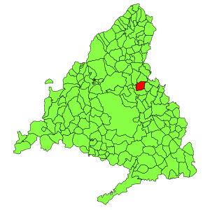
Municipal location within the Community of Madrid.
| |
| Coordinates: 40°38′10″N 3°30′40″W / 40.63611°N 3.51111°W / 40.63611; -3.51111 | |
| Country | |
| Autonomous community | Community of Madrid |
| Population
(2018)[1]
| |
| • Total | 6,541 |
| Time zone | UTC+1 (CET) |
| • Summer (DST) | UTC+2 (CEST) |
Fuente el Saz de Jarama is a municipality of the autonomous community of Madrid in central Spain. It belongs to the comarca of Cuenca del Medio Jarama.[2]
| International |
|
|---|---|
| National |
|
| Other |
|
This article about a location in the Community of Madrid, Spain is a stub. You can help Wikipedia by expanding it. |